
TOWNS (etc)
Town & Township Information
see LARGE list of towns ( 543 +) see below
Thanks Suzie & Jerry for a big chunk of 'em; Dellie Craig, Kim Hancock, Chris Hayes (for the 500th) and we are going beyond !!
We have now found 543-- YIPPEEEE next goal 545 - probably never get there, though but then again, who would have guessed we'd ever hit 100 or 200 or ... !!! :)
Here is a link to a Power Point (converted to PDF) I did about the towns in the area - then on the bottom of the page, there are many more :)
My Kind of Town - note do not steal this as your own - I did it just couldn't find the original to add my name to it as I gave it as a presentation and didn't need my name - lol. I DID IT THOUGH - kbz
For the most part the following have combined several once separate pages into a central location. There is a description of the Township from various sources, the list of Residents from the 1874 People's Guide Directory, and in most cases, a list of early Land Owners, back to 1820.
Also, a list of towns and other localities of the county can be found at the bottom of the page. Many of these have been found, updated or deleted :) from local historian, Jerry Turner - Thanks J!! as well as my daughter, Suzie Zach Baldwin, plus others along the way. Hard to believe one county in Indiana has had so many places someone called home. ENJOY!!
Township Information
Brown Township Original Landowners , also includes the 1874 Peoples Guide -- see Karen's Brown Township Power Point and PLEASE if you use if for anything, GIVE ME CREDIT - spent many hours making it, so my name and the title could be a big thanks :)
Coal Creek Township Original Landowners (1874 People's Guide) and (Landowners but do not have the Deed Bk and page # - names only - thanks muches Jeff S)
Madison Township Landowners (1874 People's Guide only)
Ripley Township Original Landowners (but do not have Deed Bk & Page # -- names only - thanks to Jeff S) And
Ripley Township Landowners (1874 People's Guide only)
Scott Township Original Landowners (1874 People's Guide only)
South Union Township Original Landowners (1874 People's Guide only)
Walnut Township Landowners (1874 People's Guide only)
NEWS ARTICLES
***MONTGOMERY COUNTY LOCALITIES ***
If you have a "locality" that is not shown here and and can document a reference, please submit it to Karen Zach == it is interesting to see this page grow and grow -- it started out 13 years ago as maybe 10 towns -- it's growin' --really growin' -- so, help it grow some more as I doubt I still have all the towns and areas of our County
You might like to try these sites, as well:
How many towns in Montgomery County? An article by Karen Zach in "The Paper of Montgomery County" on October 24, 2019.
Thanks!
* TOWNS (etc) OF MONTGOMERY COUNTY *
Thanks to my town gurus (mainly Suzie, Jerry, Bill B, & Dellie) we have discovered 535 (Here & There) towns and communities (WOW) in our county as of
NOTE 1 : to help you flip-through quicker, the blue indicates towns; dark red indicates townships; black indicates roads - ENJOY
NOTE 2 : We feel that various advertisements to this affect for all the papers prompted folks to "write" and some of the below places may have been "prompted" so a writer could do just that - - heehee. Crawfordsville Star 9-12-1895 -- "The Star wants a good corresponent from every town, village and cross roads in the county. If you wish to act as our correspondent notify us and we will send you by return mail material and instructions!" And that folks .... is likely the BIG reason why we have over 500 places in Montgomery County.
Scroll Down or use this handy index
There are no Towns that begin with "X" or "Z"
Airline -- . I found N.J. Hostetter with land in Walnut Twp. Sec 30 & 31 under the "Airline Sifting" name - but, this was 1895 & the paper was DIFFICULT to read.-- Suzie. - in 1898 atlas it is west of Whitesville and east of Greenwood Corner.
Akers -- see Merry Widow
Alamo - SW of Crawfordsville on Co. Road connecting to State Road 25, State Rd. 32 Ames - Just south of Crawfordsville. See the Alamo Town Album and Bill Boone's Alamo Warrior blogspot (it's nifty) as well as the Alamo School page on this site :) Love more pics - send 'em my way - kbz -- Source: Crawfordsville Weekly Journal 17 Sept 1868 "From Yountsville" - Our little hamlet is situated on the border of Ripley Township, and is more remarkable for what is has not than for what it has. We have neither grocery, dram shop, saddler shop, nor drug store, and there are several other branches of the trade in which we are deficient. But we have a most excellent merchant flouring mill, a superb blacksmith shop, a complete boot and shoe store, and a fine toll house which the traveler cannot fail to notice. Lastly we have the Exchange Woolen Mills from which daily may be seen to emerge hosts of pretty lasses and greasy laddies, their day's work finished, going to their homes with light steps and lighter hearts. The writer has also observed four sickly looking youths enter the mill soon after the others had gone and engage in the pleasant occupation of nightwork. And up in the small hours the old wheel may be heard, sounding as unmelodius as a guitar out of tune, or a violin at a meeting house... Tom Tattler has given a history of the business and working capacity of the mills, consequently I need not repeat it. The operatives are more than ordinarily intelligent, compared with similar establishments. "There are received at this place, weekly, 65 newspapers and periodicals, including 16 of the Journal and one of the Review. The later, with one copy of the LaCrosse Democrat, makes the sum of the Democratic newspapers received here. Alamo early history
Allnut Road -- 1050 S (thanks, Suz)
Ames -- see map, thanks to Jerry T
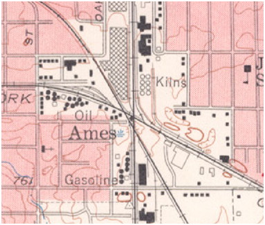
Antioch -- just East of Waveland, mentioned as a location of the Christian Church in Hiram Pratt's diaries
Ash Grove - Clark Township - Scott Township line - around county line road 1200 S (thanks, Ms Suzie)
Ash Pile & School -- near 74 in Wayne Twp 500 North near Fountain County Line (thanks, Ms. Suzie Q) --Source: Crawfordsville Weekly Journal 31 Aug 1900 p 7 “Prairie Edge news item” – Bruce Rafferty will teach school at Ash Pile this winter. He is an excellent young man and will be sure to win the respect of all his pupils - kbz
Ashby Mills -- was a railroad stop (Louisville, New Albany and Chicago RR) and small area, once quite a prominent commercial center - in Clark Township touching Putnam County - extinct but Olen Gowens & Harley Rector refurbished one of the old Ashby (called Ashby Place) homes and another is currently (2004) being restored - it is believed to be the oldest existing home in the county - located 3 1/3 miles south of Ladoga. It was in existence fairly early and up to at least 1876. There was also a Forest Home there, whether that was a home at Ashby Mills or if it was a town, not sure :(
Bad Medicine -- The Source: Crawfordsville Star 4 Oct 1883 p 5
(Under Black Creek News) - Elias Francis of Bad Medicine had the largest crop of potatoes on the creek – over 200 bushels. Having no team of his own he hired Thomas McClamrock to haul them to town. When Mr. Francis was at home Tom could load his wagon in an hour but when he was not at home it took Tom an hour and a half to load. The propriety of having a buss is obvious!
Bald Hill --1 miles north of Yountsville - in 1864 Atlas and history section (thanks Suz)
Balhinch - The northern boundary of Balhinch according to Bina Sarver, Memories 1816-1916, was Rattlesnake Creek. However from another source they state the northern boundary as Happy Hollow (one of your locations that needs to be located, lol) along Offield Creek and I think this is more accurate. The naming of Balhinch is credited to Alexander Weir and I am sure you know the story. He settled in section 16 of South Union Township and the 1878 atlas shows an H. Weir on the southwest corner which is the mouth of Offield Creek. He also owns a lot of property in the section below on Rattlesnake Creek. The other boundaries seem to be in agreement, Sugar Creek to the west, and Kerns Creek to the south. Opossum Ridge runs along Kerns Creek and that is another of your locations which isn’t located. The two churches were the Salem Baptist Church which burned down and United Brethren Church. Schoolhouse #20 was a white one room frame schoolhouse built on the corner of the Stump farm. The school was called the Stump School for that reason and it closed in 1916. There was a Balhinch Post office in 1888 called Offield Post Office with Martin V. Holloway as postmaster but I have not pinned that location down yet. There is a congregation of buildings in section 15 including a sawmill and it looks like a small hamlet, and this could be where the Post Office was. It also seems there was a ginseng craze in Balhinch from 1825 to 1830 with settlers digging the root up all over the area and selling them Major Elston. He is reportedly bought thousands of pounds before the supply ran out. Thanks to Jerry Turner for a MUCH better description than I had! MORE ON BALHINCH (Offiel) -- Post Office Department Jan 17, 1888
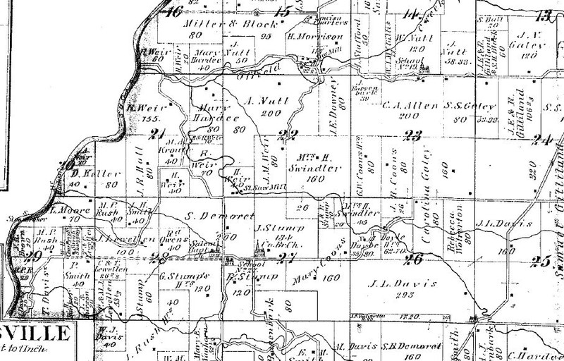
Sir: Before the Postmaster General decides upon the application for the establishment of a post office at Bal Hinch, County of Montgomery State of Indiana it will be necessary for you to carefully answer the subjoined questions, get a neighboring postmaster to certify to the correctness of the answers and return to location paper to the Department, addressed to me. If the site selected for the proposed office should not be on any mail route now under contract, only a “Special Office” can be established there to be supplied with mail from some convenient point on the nearest mail route by a special carrier for which service a sum equal to 2/3 of the amount of the salary of the postmaster at such office will be paid. You should inform the contractor or person performing service for him of this application and require him to execute the inclosed (sic) certificate as to the practicability of supplying the proposed office with mail and return the same to the department. Very respectfully, AE Stevenson, First Assistant Postmaster General
To Hon. James T Johnston care of the Postmaster of House of Reps who will please forward to him.
Statement
The proposed office to be called Bal Hinch – marked out “Offiel” written in – (Select a short name for the proposed office, when written will not resemble the name of any other post office in the State.
It will be situated in the NE SW quarter of Sec 27 Twp 18N 5W in Montgomery County.
Will it be directly on this route? It will not be on or near any route.
Where will the mail leave the present route to supply the proposed office: Crawfordsville PO
Where intersect the route again? Will not intersect any route.
What PO will be left out by this change. None
If not on any route is a “Special Office” wanted? Yes to be supplied from Crawfordsville Indiana
The name of the nearest office to the proposed on on the same route is Crawfordsville the distance is six miles in a NE direction. The name of the nearest office on the same route on the other side is Alamo a distance of 10 miles in a SW direction. The name of the nearest office to the proposed one not on this route is New Market a distance by the most direct road 4 miles in a SE direction from the proposed office. The name of the most prominent river near is Wabash River – 20 miles. The name of the nearest creek is Sugar Creek – 1 ¾ miles west. The proposed office will be 20 miles from said river on the East Side and will be 1 ¾ miles from nearest creek on the East side. If on the line of or near a railroad on which side will the office be located; how far from the track and what is or will be the name of the station? It is 3 miles air line (4 miles by road) from New Market station on Indianapolis-Terre Haute RailRoad. What will be the distance for the proposed site to the nearest flag station? 3 to 4 miles as last answered. Name of Station: New Market. What will be the distance from the proposed site to the nearest station at which mail trains make regular stops? 3-4 miles. Name of station? New Market 3-4 miles as above described. If the proposed office is located where it can be supplied from the flag station .. where mail trains make regular stops will the mail be carried to and from the proposed office without expense to the Department – cannot be done. If it will be a village, state the # of inhabitants – answer has a long line so guess not ☹ Also, the population to be supplied by the proposed office would be – about 260. Diagram attached. All which I certify to be correct and true, according to the best of my knowledge and belief, this 21st day of February 1888. Martin W. Holloway, Proposed Post Master.
I certify that I have examined the foregoing statement and it is correct and true to the best of my knowledge and belief. JA Booe for MJ Compton Asst PM Crawfordsville, Indiana.
Ball's School House -- In the Weekly Argus News June 30, 1900 (THANKS JERRY T) Ball's School House is listed as one of the places that sent in news -- mentioned are Floyd, Agnes, Isaiah and Catherine Ball; Mary Thompson, May Bard and Ota Decker (taking music lessons in Waynetown); Perry Brannon, Roy Wilson and Frank Vaughn visiting New Richmond and Jim Graham delivering hogs to C'ville. Obviously it was named for the James Ball and Catherine Hoff family. Catherine is the one mentioned that son Isaiah came to see. She actually passed away while he was here. (June 27, 1900). A ball-park figure (PUN) of where this was is somewhere near the Wesley Chapel Church / Academy. Likely in Wayne Township. Anyone know for sure, PLEASE let me know info Sherry Legg Young
Ball School was just down the road from me! It was almost at the corner of 650 W and 100 N. On the west side of the road. The Ball Cemetery is on 100 just east of 650. They are just south of Christian Union Church and not too far south and west of Wesley.
Barcus Orchard - well, do you ever say DUH to yourself when you finally understand. I've always known "Barcus Orchard Road" - lived around the corner from it for 20 years BUT well, duh there was a school and a town there too !! So this is our (DRUM ROLL) TOWN #500 -- thanks to Chris Hayes
Barcus Orchard Road -- off of 47 South, the west side of Road 300 South
Beach Croft -- Source: Weekly Argus News, May 27, 1899 p 7 - Various names and doings mentioned - Tank Lawters smiling countenance was seen on our streets last Sunday. Scott Messner returned to this city Saturday from Covington where he is engaged in railroading. Ephraim Vanscoyoc and family of Wingate were the guests of relatives last week. Frank Linn, Jim Everson and their families were at Pierce Retinger's the first of the week. Bill Morris and family are visiting relatives at Mace this week. Olga Fall accompanied a Crawfordsville party to the Shades last Sunday. George Lollis says he is an excellent mower when he has a sharp scythe. George Lollis took dinner with JC Goodbar and wife last Sunday. Peter Fydell is erecting a fine new residence on the corner of Elm and Water Street (this sounds like it's in Crawfordsville but still under Beach Croft).
Beach Ridge -- found in January 1875 newspapers by Suzie Zach Baldwin - thank you daughter of mine :) Endicott & Armstrong are wanting to start a saw mill -- the same things were listed under "Smithville" so it is obviously near there and best guests (Endicotts; Armstrongs; Armstrongs, Wheelers, Rhoads are all in the Darlington / Franklin Township area).
Beavers Station - Sugar Creek Twp. - - in 1864 Atlas "geography" section (thanks Suzie)
Beck -- this was a stop on the Northwestern Interurban line - between Walnut & Franklin Townships - about 1910 = could be same as Beckville but not sure as of 9-22-2014
Beckoning Woods - off of 136 - east side of South Union Township (thanks to daughter, Suzie)
Beck's Corner - nothing is known about this area other than it had a post office for a few years (5-6-1854 to 7-10-1860) - thanks Suzie :) - it was 4 1/2 miles from Colfax in Montgomery County.
Beckville - due east of Mace, on County Road 200, close to Boone County line -- never platted but it was a hamlet in Walnut Township. According to the Walnut Township History book by Walters it says, "Beckville became Orth in 1865."
Bed Bug Corner - Coal Creek Township, corner of 1050 North and 525 West (from Suz). Addition by Jerry -- just west of New Richmond on the northeast corner of 1050N and 525 west. Supposedly a large house existed there and took in travelers, like an Inn, and the beds became infested with bedbugs. So it became known as Bed Bug corner. (Note: you have 1050S). Note on 5-15-2013 via Suzie Bedbug corner got its name because the "Inn" found at the corner just west of New Richmond got so many "bedbugs" from the many travelers that no one would stay there any more - YUK!!!!!!!!!!!!!!!!!!
Beech Grove -- On the 1st Saturday in March, June, September and December, the Horse Thief Detective Association met here Montgomery County - most of the listings in the old newspapers were from Montgomery so assuming it is here. Source: C'ville Star, Aug 3, 1875 p 2 - Beech Grove is situated about the center of what is known as the "Bend of SUgar Creek" and is surrounded by the finest and most productive land in the county. Our productions are mostly wheat, corn and hogs. Wheat is all cut and will make a good average yield; corn is looking well; and there will be a good number of hogs fattened this fall ... we have a Horse Thief Detecting Assocation," with aobut 30 memers: LJ Brawley, Pres; Will Chambers, Scribe ... we can also boast of our full share of old settlers. Uncle John Remley, Sol Ball and Henry Liter, whose ages are about 70 and who have been here over 40 years. They can give some very interesting accounts of the early settlers."
Beecher Still - South Union - western side (thanks Suz - never heard of this one )
Beeville - thanks muches Jerry T -- located about 2 1/4 miles northwest of the Turnipseed Corner/Ford/House. According to oral transcirpts of Azel Trunipseed (born 1890) this was a little trading post back in the 1800's. The supply Wagon (Huckster Wagon?) would come through and deliver supplies to the trading post. These trading posts were all over the county. When asked how it got the name he said "I suppose somebody got stung there sometime and called it beeville.
Bell Cross -- Source: Crawfordsville Star, June 3, 1897 - this is evidently above what is now, 2015, Interstate 74 and possibly up to the Breaks School area. -- notes from this article are that Wheat looks very bad in the vicinity - a 1/4 of a crop, a bread famine and prosperity. Children's day at Soap Factory Sunday School in the afternoon 2nd Sunday in June. Dick Bible is planting corn. Plans to build a woven wire fence. Spence Lee planted his early potato crop. Political note was, "What is the difference beween the Cleveland panic and McKinley properity?" Thanks, Jerry T.
Bell Road -- 150 South (thanks, Suz)
Belladona - Weekly Argus 5-27-1893 -- Charles Bratton has had queer spells since his dog bite. Charles Crain and wife are going to the world's fair. George Coap - working on the Sugar Creek Bridge
Big Ditch -- Crawfordsville Star, Nov 4, 1886 p 5 -- "Big Ditch" news - Mr. Senor Barker has returned to his home in Kentucly. Tom Steel's dance was a success it being the first of the season. Mrs. River Steel, who had her shoulder dislocated is better. John Kerr's funeral was preached at the Methodist Church last Sunday. Capt. Kelley has gone into winter quarters. He has built a house on the ditch bank. Lew, the youngest son of Sylvester and Kate Morris, died last Thursday and was buried Saturday at Oak Hill. - kbz -- Star Nov 11 -- gives an overall idea of where it is -- "There is two certain young men in the NE corner of Madison Twp who go to Crawfordsville about once a week as they go home they are pretty loud, and use rough language and if it is not stopped their names will be given the next time.
Big Slough Ford -- in Sugar Creek Township north of Crawfordsville - the bid from MU Johnson & Company was accepted for $1,070 on May 7, 1901 by the county commissioners to build two, 40' iron bridges here
Big Spring -- Section 22, Franklin Township - 1878 Atlas of Montgomery County
Binford -- (Garfield) -- Train station in Union Township according to the 1878 Montgomery Co Atlas, 6 miles NE of Crawfordsville on the IC & SW Railroad Binford was originally Binford Flag Station on the Vandalia Railroad which operated a coal yard, turntable and roundhouse there. Peter Binford bought the land in 1829 but it was not till 1849 that his son David moved onto the land. The Binford Wayside Log Inn housed many a traveler and at various times there was Kelsey's Grocery and Notions Store, Motes Saw Mill, Thornburg Brothers Brick Kiln. William Grist's Tile Kiln, Pittman's Cooper Shop, and other industries. The underground railroad used one building on the way to Thorntown. Two churches and a school were located here at various times. The name changed to Garfield because of the Post Office. The residents in 1880 applied for a Post Office named Binford but because of similar names (Bedrord, Bradford) in Indiana it was rejected so they resubmitted it as Garfield Post Office (PM Isaac T. Kelsey:1882) and the name stuck. just west of the town was the Quaker Meeting house of Sugar River. (Thanks muches Jerry for this great additional information)
Black Creek - Black Creek is a tributary of Sugar Creek and began somewhere just east or northeast of Cherry Grove. It used to drain the Black Creek swamp which was south and south east of the US 231 overpass of the CSX RR tracks south of Linden. Black Creek flows into Sugar Creek just east of the Sugar Creek Trail bridge west of Crawfordsville.
Black Creek did have a grist mill (Potts Mill built in 1854) and a saw mill on the same mill race, located south of the US 136 bridge over Black Creek about half a mile down the creek thus basically, a community. (Mill source: Crawfordsville Sunday star May 12,1902) - JT -- Black Creek Valley Ridge Road -- runs north and south from 136. More proof - Crawfordsville Star, Thurs Nov 8, 1883 - Alvin Breaks has finished his new house. The pioneer tile man, Sam Petro, and his young wife, were visiting on the Creek last Sunday. John Mills lost a very fine cow somet 10 weeks ago. He went to the mill and and laid in mill-feed enough to winter his cow through until grass next spring, and she broke into the feed shel that night and cleaned the platter. Asher Wirt (sic - Wert) one of our supervisors is doing the best road work ...
Black Swamp -- Benjamin Milton Vancleave - born 19 May 1842 in Black Swamp ... 10 miles south of Crawfordsville -- his father's (David Vancleave; mother Sarah Jane Vancleave) land was 2 sections North of Parkersburg -- Sec 19.
Blackville -- this just makes me mad but I had nothing to do with it, I guess - kbz -- evidently a portion of Crawfordsville, my guess would be near the old jail since the A.M.E. church was in that area. Crawfordsville Star, Feb 5, 1885 p 1 -- "The rink craze has attacked the colored population and a rink in Blackville is contemplated."
Blaydes Road -- 100 North (Linden Road) - (thanks, Suz)
Blooming City -- thanks Suz - March 1894 Sections 31-33 Franklin Township. Families in the area are Abe Elmore; Evi Martin; Enos O'Conner; Suttons; Custers; Trouts
Blue Eyes -- Sections 15/16/21 of Franklin Twp. -- Source: 25 July 1902 Cville Journal -- Seth Crowder was improving but Addie Stewart was sick. Henry Cox was building a new fence; there was a new gravel road being built -- Sleepyeye George Spry is home from Chicago; a new bridge on the Mary Pickering Ditch is built; Harry Williamsons must have had a girlfriend in Darlington; Walter Stewart wanted to buy a fast driving horse; there was going to be a bicycle race at Flat Creek Sunday a.m. between HA Stewart & SC Trimble. A charivari was given for Lilly Johnson and her new hubs, Enrich Paddock. -- Source: 30 Dec 1904 Crawfordsville Wweekly Journal -- land owners in 1904 were: Hiram Faust (Foust), Sherman Trimble, Frank Buchanan, Homer Price, Herman Stewart
Blue Heron Rookery - near Beckville (thanks Suzie)
Blue Hole -- a swimming spot in the 1940-50s off of 136 on Walnut Fork (not sure if it was a town/area/or just the swimming hole but it had a name, for sure (thanks Mrs. Welliever)
Bluff Mill-- also found as Bluff Mills. this was basically the Deers Mill area near Shades State Park -- my great grandparents moved here in about 1894 on until their deaths two weeks apart in 1926 and it was always called Bluff Mills throughout that time-- it was at one point a thriving little community -- its post office existed 12-10-1886 to 5-14-1904 with Joel Deerr beginning as Post Master followed by Wm. E. Etter and lastly George W. Deer (from 30 April 1900 until closing date)
Bonwell Corner -- 700 South connecting to US 231 South (thanks, Suz)
Boot Hill - West of Finley Chapel Cemetery (thanks Suzie)
Boots School House -- not sure if this is just a school house or more likely an area grown-up around the school, but on the 2nd Saturday in September, December, March and June the Horse Thief Detective Association met here but not sure if this is in Fountain or Montgomery County - most of the listings in the old newspapers were from Montgomery so assuming it is here.
Boraker's Corner -- Weekly Argus News May 3, 1890 - Michael Lowe killed by Big Four Railroad as he crossed - (one mile west of Sugar Creek near the Ripley/Wayne line.
Bossom Ridge -- at first we thought this was Possum Ridge but they are not the same place, Possum Ridge being five or so miles to the north of this place. Jerry Turner found this one in the Crawfordsville Star 8-4-1881 -- various items in the article under "Bossom Ridge" are: Ice cream flowed in copious streams at RR Whittington on July 20th. Mollie Reynolds has charge of a loom at Canine & Deer's Woolen Mills. Dug Haynes & wife were guests of RL Whitting & wife, Sunday July 17. Mattie Whitting and Pollie Miles were guests of Ellen Whittington July 23. There was 122 persons dined at Pine Hills Sunday July 24. The party now encamped at Pine Hills visited Shades of Death Saturday June 23. Thomas Miles and wife, Lewis Reynolds and wife and Uncle Goerge Miles took in the Pine Hills, Sunday July 24. The corn on the uplands bids fair for an average crop while the corn in the Sugar Creek bottoms will be past average. The prospect for a good potato crop bids fair if not molested by the vile bugs. Bossom Ridge would be in the Pine Hills are -- see map.
Boston Store -- this is present day Elmdale. In 1832 Daniel Bennett built a house with a storeroom on a corner of the intersection of two roads, one being the Crawfordsville Williamsport road known today as Old State Road 55. He placed a canvas sign he brought from Columbus Indiana on the side of the store. The sign read “Boston Store.” So over time travelers along the road saw the sign and called the crossroads "Boston Store." A small community grew up consisting of a couple of stores, blacksmith, wagon shop, a couple of churches, school, 2 story grocery and a Post Office. It was the Post Office and confusion with another Boston Store Post Office which caused the name to be changed to Elmdale. Thanks to Jerry T, my town guru :). Guruess Suzie added that the Post Office at Boston Store existed from 2-1-1866 to 10-24-1882. Thanks to both my historians!
Boulder Valley -- Sec 30/31 area of Walnut. Imel, Coulter, Stone & Hays most mentioned names - 1894
Bowers / Bowers Station - (click name to see the Bowers Photo Album - sure love to have more pics for this one ) -- located on County Roads 800 North 1000 East - created 11-11-1901 by Christena & L.M. Dunbar, Section 26 Sugar Creek Township, at one time known as "Clouser's Mill." Bowers was one of the biggest shipping centers in our county in 1878, and some of the wealthiest business men and farmers lived in this section of the county. Sec 23 This from Jerry T -- Bowers and Bowers Station were the same . The village of Bowers had existed many years before it was officially platted on 11-11-1901 by Christena & L. M. Dunbar. The village was located in sections 26 and 23 seen on this map. When the railroad came through Abner Bowers donated land for the depot and the village became known as Bowers Station. The Clouser Post Office originally located at the Clouser mill on Sugar Creek was moved to the General Store in Bowers Station and became known as the Bowers Station Post Office. See map JT sent - thanks Jer
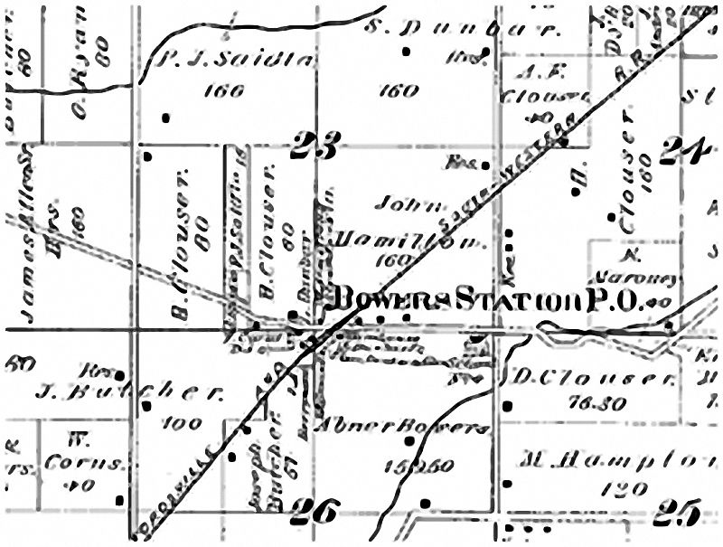
Brenton’s Cathedral – the week before this paper, Crawfordsville Weekly Journal, in the CWJ there was a short obituary for Miss Lulu Gunkle that mentions she lived near Whitesville, then this week, under “Brenton’s Cathedral” it notes, “We were pained to hear of the death of Miss Lulu Gunkle. Tried everything to find where she was buried or anything about her or father. Tried Lulu; Lula; Pearl; plain Gunkle for all of Indiana; and then thought, “Oh, maybe it is Kunkle.” Well that was the right idea – she was Lula Pearl Guntle 13 July 1878 – 12 Nov 1897 and finally found her buried in Harshbarger Cemetery near Ladoga, some spelled Gunkle, the twin sister, Lola with Guntle, buried at Harshbarger as well. Other people mentioned in Brenton’s Cathedral were Joseph Moody; Roy Galey; Tobe Harris; Lizzie Weeks; Bert Linn; Clarence Perry. Only found three mentions of this – all in 1897 all in the Weekly Journal – one was 8 Oct p 2 – mentioning the school is progressing nicely with Mr. McGaughey (as teacher, assumedly) and later mentions on Oct 15 they would have a pie social at the school. Mrs. Minnie Linn moved in with her mother, Mrs. Beck; Frank Linn and family of Whitesville visited his mother; many attended the picnic at Crawfordsville. The Dec 17th article mentions Wilbur and Nellie Hipes; George Hunt working for Joe Moody; Hannibal Finch will spend Christmas in Brazil. “Talk of having a supper at the church soon!” Joshua Evans returned home from Lafayette Friday.” Evidently the name derives from the local church as this was noted “The members of the chapel have placed a new fence around the church which has improved it considerably!” There are several mentions of “Brenton School House,” with most of the same families mentioned – CWJ 8 Dec 1893, “The basket supper at Brenton School House was a howling success. After supper a prize was offered for the ugliest person present. Mr. Galey was winner!” In another column (Wake Up) it notes the same “box supper at Brenton’s School grand success – proceeds $6.00.
Brickyard Road -- 200 North at interesection of 25 then to Road 100 East (thanks, Suz)
Bristle Ridge -- Coal Creek Township - 970 Nort h out of Wingate between 625 & 575 W - Suzie sent me this note : Article written by John Bowerman in 1984 (Dec) stated that the area just SW of Bristle Ridge is called "Kentuck" because the people living there are all from Kentucky. See also Buffalo Ridge and Honest Ridge -- more info: Source; Crawfordsville Star, March 2, 1882 p 4 -- The history of Bristle Ridge has been handed down from generation to generation until its early history is lost. If we are to judge the past by the present, we will not speak unfavorable of the society on the Ridge. We look around over the country and see it dotted here and there with school houses, which shows that virtue and morality dwell in the hearts of the people. The little state of Macedon, nestling among the mountains of northern Greece was unnoticed by the rest of the world until she gave forth a Phillip and an Alexander. It is only through perseverance and integrity that success is attained; encourage Sunday schools for they are the basis of society. The Sunday School field is broad and many are the little intellects to be included for Christ which tend to elevate and make moral men and women. Show me a country Sunday School well carried on and you will find a virtuous and intelligent people. The truth that is instilled into the youth shows in the man or woman. Let us step into the field with renewed zeal. Organize early and strive to plant the seeds of truth in youthful minds and make Bristle Ridge a model. Note: One explanation for the name from Beverly Schnepp - "My dad said the original owner stole hogs and butchered them and buried the bristles so no one could find the evidence."
Britton's Glen - bit iffy whether this could be called a town but it is definitely a place referred to many times in the old articles -- in the Weekly Argus News 2-10-1894 p 8 - when the old Orphan's Home burned, Britton's Glen was mentioned as a possible building site. My town scout, Jerry Turner pegs it as being located south of the Schenck Road and the old Perrysville/Yountsville (1950s) road.
Britton's Grove -- may be one in same as Britton's Glen but mentioned in the Crawfordsville Journal 3 May 1895 - talks about Andy Young and John Goben - probably on or near Sugar Creek and obviously near the little town of Tilneyville
Britt's Road - 1000 S between 375 E & 550 E - Scott Twp
Brooklyn-- on Country Club Road or Rock River Ridge Road since the boys came through there to the Troutman Pond which is the Sportsman Club now. - thanks jt :) From the Weekly Argus News April 30, 1892 -- these are names listed -- Miss Augusta Bowes spent Sunday at Richard Chastines. Rev. Marion Baker of Merom, visited friends here Saturday and Sunday. 13 Crawfordsville boys passed through here one morning last week on a fishing expedition to Troutman's pond and returned late in the evening with three fish which averaged 2 1/2 " in length. Work of remodeling Wm. Remley's residence is under headway ..Randall and Russell Lookabill claim to have the finest private collection of Mound Builder relics in the county. Elijah Myers, of Fountain County drove a team of 2-year-old mares through here the other day for which he refused $600. Last week for four mornings in succession, it was noticed by residents along the road between here and Yountsville bridge that some one was driving a horse so fast that no one could tell who he was. Some thought it was G.W. Paul, others Bob Davis and some Tude Hamilton. Saturday morning while he was returning from the bridge some naught little girl threw an old broom in the road and the horse spied the broom, took fright and whirling around upset the cart and threw the occupant over the fence in front of Lee Richards house. The neighbors quickly rushed to the scene. It was then no longer a mystery as to who the driver was. It proved to be M.E. Clodfelter of Crawfordsville who had been training his famous young Rosewood horse. Fortunately Mr. Clodfelter was not seriously hurt, the only scratch was a little bark from the end of his nose. The next morning he was observed driving through Brooklyn with tight lines at a slow walk with his wife by his side.
Brown Road -- NE of Browns Valley
Brown Township - (link to Karen's Brown Township Power Point) - found in SW part of county, Waveland is the largest town in the township. Part of the township (NW) is high and rolling, whereas most of the rest is slightly rolling. The Shades State Park lies in this section of the county. Indian Creek is the main branch and runs into Sugar Creek. This is one of the earlier sections of the county to be settled. James Long cleared the first land in the township followed by neighbor William Moore; Ralph Canine (vet of War od 1812) settled in Sec 23, in 1826 and organized the Old School Baptist Church and built the first church on his farm; P Mullenburg Sec 28 came in the fall of 1823; Isaac Davis, 1826. The Todds and VanCleaves from Kentucky were numerous as well as Reynolds; Gotts; Swindlers; Milligan being among first settlers. A portion of New Market lies in this County. Browns Valley is a small village 4 1/2 miles northeast of Waveland (laid-out by Matthias VanCleave in 1836) and was originally called Brownsville.
Browns Valley- South of State Highway 47, 10 miles and also 3 miles north of Waveland; originally called Brownsville
Bryanville -- existed in July 1898 as the Daily Argus News on the 29th says, "What's the matter with Darlington, Shannondale, Bryanville, Ireland and Hickory Corner? Hav e you all gone to war?" -- assume it is near Darlington
Buchanan - A Cross Road stop of the Ben Hur Line - about 1910 (probably in Sugar Creek Twp)
Buckhorn Tavern Site - Ripley Township, north of Alamo Conservation Club - thanks Suz
Buffalo Ridge -- 1894 time range. Northern Wayne Two & southern Coal Creek around Elmdale. See also Bristle Ridge and Honest Ridge
Bunker Hill -- In the Weekly News Review, June 14, 1901, Jerry Turner found this article with a new town (on 2-11-2015) -- names mentioned are: Edith Morrison and Hattie Layne; Charley Jeffries; Lola Wray; William Stonebraker; Minta Barnett; and this little place would be East of Alamo where Bunker Hill Cemetery owns George Stonebraker, one of Montgomery County's Revolutionary Soldier and the one to live the longest (I've questioned that though but he is I believe in the Guiness Book of Records - kbz).
Bunkum -- see Bunkim Crossroads
Bunkim Crossroads -- Town #414 -- Crawfordsville Star 9-7-1882 (thanks so much to Jerry Turner) -- Charley Eshelman sports a new buggy. Maud Elmore is better. Miss Mollie Bebee is visiting at Balsam Elmore's. The farmers are done threshing wheat - longest harvest ever. Dick Burk packed his grip sack and left Bunkum and his work as brakeman on the IB&W. Jim Kline from Thorntown was down to help Constable Pickering thresh his wheat. Oscar Sutton and Johnny Miller, two Bunkum boys have gone on a trip to St. Paul, Minn. Frank Cox attended the annual conference of the ME Church (Michigan City). Elmer Stewart and Al Lafollette visited Jordan Beck's last Sunday evening. (probably from these names this is in Franklin Township - below Shannondale - hopefully we can find more sometime) -- Also referred to as Bunkum
Bunnel's Corner -- add for a meat market @ Bunnell's Corner in the 1903-1904 New Richmond Newspaper book found by Suzie - there were about 8 Bunnel(l) families in the area at the time so to date (5-15-2013 - happy birthday nephew Rob) not sure which of those corners/families belonged to Bunnel's Corner
Burk School House - Source: Crawfordsville Star, March 4, 1886 p 5 (hoping to find more about this place in other newspapers because I don't really get a feel of where it is with these little bits) Last week an event was witnessed on the Fredericksburg Gravel Road that seldom ever occurs. Two funeral processionis met - one going to Shilo, the other to Oak Hill. Aaron Hood will move on to Samuel Gilliland's farm south of town.
Bursonville -- see Kimble's Crossroads
Bushtown -- On the 3rd Saturday in March, June, September and December, the Horse Thief Detective Association met here but not sure if this is in Fountain or Montgomery County - most of the listings in the old newspapers were from Montgomery so assuming it is here.
Buttermilk Town - near New Market (SW) - thanks Suz
Bymaster Road -- 1100 South - Hawk Creek Road (thanks, Suz)
California -- Sept 1899 Crawfordsville Weekly Journal -- SE Corner of Coal Creek Township. Sections 33,34,35 have land owners that were mentioned in the news articles.- way to go, Suz
Campbell's Chapel -- Dr. Isaac Naylor was instrumental in establishing this small area that was in Sugar Creek Township. A Methodist Episcopal Church was likely there and Campbell families, as well. Thanks Jerry T. He really has helped find these old burgs :) -- Source: C'ville Star 9-7-1875 p 8 - Temperance meeting Sunday Aug 28 - Speakers: HH Wade, Mrs. Cooley, John Darter and Miss MD Naylor.. Wade 14 names for charter members for a new IOGT Lodge.
Source: Unknown – several years ago a minister was working on an advanced degree and did a MAJOR amount of research on the churches in Sugar Creek Township- this is from page 44 of the book he wrote
1869 – Rev, WG Vessels the “Boy Preacher” opened a meeting in Potato Creek School and the meeting place became his permanent appointment. In the winter of 1870, his revival was huge – the crowds came at the end of the school day and were overflowing long before the meeting was to begin. Campbell’s Chapel is in the extreme SW limits of Sugar Creek Township. (Thanks MEF for the help) -- thanks so much to Ray M. Dibble - information from An Economic and Social Survey of Potato Creek Neighborhood" by him
Card Road -- 200 East (thanks, Suz)
Carrollton - (thanks Jerry Turner for this information) Carrolton was a small town that existed only a few years after 1830 in Clark Township. A large section of land in the area was purchased in 1825 by Jesse Inlow and given to his children. One son, Abraham, had a daughter who married John James. James and his wife settled near the schoolhouse and platted the town of Carrolton in early 1829. Several lots were sold and James built a store and a blacksmith shop. The blacksmiths name was Huston. The town sat alongside the Crawfordsville/Danville Road (today this section is called 750 South between 700 East and 750 East) in Section 9 of Clark township, 2 miles northeast of Ladoga. In 1833, Jacob Harshbarger bought half interest n the store and several lots. But Ladoga was platted seven years later and possessed a mill making it the center of the area. Interest in the town evaporated, the blacksmith moved to Ladoga and Harshbarger sold out his interest. The Inlow Cemetery is located just to the northwest of the small village. Now the school (No. 2) probably had a name which I have not found yet.
Carvers Corner - Source: Crawfordsville Star, May 5, 1887 -- Harry Sweeny commenced work again at Mike Johnson's after a two weeks' case of measles. Little Billy Galloway and James Armstrong beat everybody planting corn this spring. Pure guess but would think with the Johnson, Galloway and Armstrongs that this would be somewhere near the Mace area. Let me know if anyone discovers more on this one :)
Cassida Road -- 550 North (thanks, Suz)
Caster -- a stop on the interurban between Walnut & Franklin townships - about 1910
Cedar Mound -- in 1898, New Market was either called Cedar Mound or Cedar Mound was right in the vicinity as in the October 8, 1898 Weekly Argus News (thanks Jerry T for finding this) the heading is: Cedar Mound (New Market) -- George Himes and Joe Busenbark "have been losing hogs from cholera." Harry Lee visited Shoemakers; MC Tapp lost 7 hogs last week - overheated. George Hime, Lee Surface, Billie Poynts and Busenbark Brother working on road taxes.
Cemetery Hill -- That is the hill west of Lafayette Avenue (old 231) north of Sugar Creek that goes up to the Oak Hill Cemetery - Jerry T.
Centennial House -- waiting on Jerry Turner, my town guru to find more :)
Center College -- Source: Crawfordsville Star, oct 27, 1887 p 7 - "Center College" news items include Mont Booher (shucking corn for WB Mount) - John Trimbles new house ; Kashner - teacher - Wm. Craig sold interestin the grocery at Ladoga and is at home - some boys entered the school house and carried away some of the property belonging there - better look sharp as they are well known in this vicinity.
Center Grove - oh, thanks Jerry T - this made the 250th town - whoopeee -- The community of Center Grove was located 3 miles southeast of Darlington. The exact location is hard to pin down but it was in sections 14 of Franklin Township. The Unitarian Christian church was the center point of the community until the church burned in 1864. The fire caused a division of the congregation with some (the Union Party) moving to Darlington and the others took over the United Brethern Church in section 12 close to the county line.
Center School House -- Daily News Review June 12, 1901 p 2 - Boyd Clouser and wife attended Catholic meeting at Crawfordsville Sunday. Scott Peterson and family Sundayed with Amanda Harshbarger. Frank Cool deliver mail..Several from this place attended the K of P decoration services at Darlington Sunday afternoon. I would assume this is north and east of Darlington from the people mentioned but not sure. Hopefully, we'll find it soon - kbz
Centerville Road - Wayne Twp - 450 N
Cherry Grove - on Hwy 231 north of Manchester -- a large grain storage bin is there now - it was a train stop - more info from Jerry T, one of my great town gurus :) The old Cherry Grove elevator was 2.4 miles north of the current elevator. So the location of Cherry Grove is 2 miles north of the current elevator.
Chigger Hollow - see Shiloh - thanks Jerry :)
Chilkoot Pass -- this has to be somewhere where Brown, Union and Scott township corner due to the names (Penn; Rush; Wray; Sarvis; Voris; Grider; Reeves; Hicks; Childs and Dallas) found in the Crawfordsville Weekly Journal of 22 April 1898. Also this nifty little piece was found (same source) : Source: Crawfordsville Weekly Journal 22 April 1898 - Chilkoot Pass -- In the event of war, the Pass will organize a regiment of about 50 men. It will be known as "The Regiment from the Chilkoot, with T.P. Brown, Captain; Dr. BF Rush will be surgeon and Davy Pen (sic Penn) 1st Lt. J.M. Dallas will be chosen Chaplain. -kbz --
Christian Union -- a community built-up in the Christian Union Church area near Waynetown. This began in 1867 - built on Road 600 West one mile south of State Road 136. Schenck; Henthorn; Barnetts were active members in the early 1930s. Not sure if the church is still there today.
Circle Road - north off of 136 on 750 West
Civil Corner -- Far Eastern part of Ripley - around Sec. 20 - Stubbins & Larsh were mentioned - May 1896
Clark Township - lowermost SE township; the town of Ladoga is the largest town in this township. Good, fertile farmland. Big Raccoon and Little Raccoon, plus Haw Creek run through the township. A latter area for settlers, the pioneers of the township were Harshbarger; Peffley; Otterman; Hines; Stoner; Hicks. John Myers laid-out the largest town, Ladoga in 1836. In 1878, there were several industries, including Daughterty's flour mill; Anderson; Bradley and water mill of Bateman. Ashby Mills laid out as Forest Home in 1871 was located near Haw Creek.
Clark’s Mills – found by Jerry Turner in an 1852 Montgomery County map – possibly could be just a mill but there is a dot like the other towns so until we find differently will add to the town list (lower western part of south Union township)
Clarkson Ditch -
Clinesville -- in Walnut Township, Sec 20 - created 3-19-1870 by D.D. Smith & D.D. Berry located one mile southeast of Mace -- article about Sarah Sweeney (husband Stephen) -- 2 miles East of Mace -- 1885 - Woman got killed by train here - so it was "In the News" - train must have ran pretty close by there - Was sad - she got ran over & her son returned home from his wedding as they found her :(( via Suzie B)
Clore's Grove -- this is likely in Upper Brown or lower Ripley - Clores owned land in several Brown Township sections (10-12; 14-15; 22; 34) but others mentioned under Clore's Grove are Rhoden Ham, Ed Smith and Otis Fruits who are definitely in lower Ripley -- could be right on the border. We're working on this one :)
Clouser's Mill - see Bowers
Clouser Road -- SR 47 between Darlington and Thorntown - also known as the Old Indian Trail and Thorntown Road
Coal Creek Township - uppermost, NW township as well as a Creek in the township. From the 1878 Atlas of Montgomery County. "The surface in the south and east part of Coal Creek Township is gently rolling, in the northwest portion of the township. The level portions are well ditched. The natural drainage goes into Coal Creek and through it into the Wabash. The northern part is prairie land. This township has no railroad. Of late years a great many improvments have been made on public and private property. In the township are located the villages of Pleasant Hill (with mail three times a week) laid out before 1836, but resurveyed and recorded in that year; New Richmond (mail twice a week) laid out in 1836; the hamlets of Boston Store PO (tri-weekly mail) and Round Hill PO (mail twice a week), Pleasnat Hill especially is a very lively business place; New Richmond, too does a fair amount of country trade. Coal Creek Township was settled up in some parts of it at an early date, in others, it was late before settlers ventured in. John Alexander in the north part near New Richmond; James Dewey; David Oppy; Simpsons, A. Kirkpatrick. Thomas Ward, Jacob Dazey, Bunnell, Wilhite, John Koon, John Luce, SAR Beach (1837) and the Meharrys are old settlers, dead and living.
Coal Creek Valley - N of Elmdale, S of Sleepy Hollow, E of Wingate, SW of New Richmond (New Richmond Newspaper book 1903-1904)
Coffeyville -
Coleman School House -- this was definitely in the Darlington area probably a bit north. Found in the Crawfordsville Star, March 4, 1886 p 5 -- Rev. Barb preached Sunday at the St. James Lutheran Church. Martin Clouser one of our promising young men is preparing to go to school at Danville, Indiana. Only one more week of school here. M.V. Faust has taught an exceptional school this winter. A number from this neighborhood attended the Friends quarterly on Sunday at Sugar Plain. The Coleman boys prepared a birthday dinner for their mother last Wednesday. She was 73 and has lived with her husband 56 years.
Colfax Road -- 1050 North l -- Walnut Township (Source: Pauline Walters Walnut Twp book)
College Corner -- although an area it was also a school house - #22 -- info from Jerry T -- Crawfordsville Star, Oct 11, 1883 -- Newt Wynn is talking of moving to Old Billyville. Eph. Vanscoyoc will soon take the hint and go south. George Weeks visited Eph McMurry's this week. Wilmer Harris visited friends - this seems to lie somewhere between Mace and Ladoga - anyone know for sure, let us know :) Thanks
Concord -- 5 miles NE of Crawfordsville around1875? --a geological report from 1875 by John Collett listed the gravel roads in the county and had this name. Near Binford Station (Garfield) or is it one or the other? (Thanks to Jerry Turner for this one :) -- Jerry writes more: "the Potato Creek-Linden road connects with a gravel road built from Sugar Creek township to the Northeast end of the Concord Turnpike and this road was 6 miles east of Linden."
Connettsville -- just Northwest of Ladoga, Clark Township, Indiana - 28 acre area - was laid out by M.A. Connett
Corduory Road -- named because of the logs used on this road were corduory like - this was later called Plank Road and today is County Road 100 West (thanks to Mike Bridge & his granddau Steph for this one :)
Corey's Bluff: -- located in SW 1/4 section 29, township 19, range 4. 1 1/2 miles north of downtown Crawfordsville and just south of the CSX railroad bridge over Sugar Creek. Was named for Professor E. H. Corey in honor of his exploration of the local crinoid beds along Sugar Creek.
Cornstalk -- Indian town near Ladoga named for its chief, Peter Cornstalk, as well as the type of Indian they were - "his people were buried high on the bluff looking down on their old Cornstalktown (Cornstalk) with a visiion of their spirirts finding pleasure in being so near their beloved stream.(The Streets of Ladoga by Bill Boone), p. 2 -- "One reason the Cornstalk Indians and early pioneers lived so peacefully together was because of the character of Peter Cornstalk, himself. He was a very agreeable person, sensible, dignified and devout, a man who could be trusted. He was a tall, fine looking chief, rather portly as to figure and with a very pleasing manner... one reason why the general character of Chief Cornstalk and tribe was so worthy was the Quaker influence under which they lived in Ohio. History tells us of the missionary work of the Quakers and the result was seen in the character of the Cornstalk Indians." p 2. p. 4 -- "The Indians were induced by the American government representatives to surrender their title to all lands in Putnam and Montgomery Counties by treaty and received little in payment. The redskin residents began leaving usually urged by American Troop soon after 1832 and by 1836 it is believed all of them had departed from our souil.... In 1836 a powwow and farewell assembly was held near Thorntown before the Indians moved westward. It is said that Thorntown was the largest Indian town near here and one which sent hundreds of warrior out to battle. This powwow is said to have lasted 12 days.
Cottage Grove - sure this was a school in Sugar Creek Township, and it was assumedly a town as well.
Council Bluffs -- not adding this to the 220 towns found yet as not sure if it is in Montgomery, Fountain or Tippecanoe (I suspicion Fountain) -- 1855 murder of John Cisena which was 8-10 miles from Linden in 1855 - Council Bluffs Eagle (newspaper) -- IF ANYONE knows where this town is, PLEASE LET ME KNOW
Council Corner -- Since it mentions Liberty and Wesley, this is in Union Township (William Gray is proprietor of the Sickle & Sheaf; don't forget the play at Wesley) From the Crawfordsville Star May 14, 1885
Council Grove -- On the 3rd Saturday in March, June, September and December, the Horse Thief Detective Association met here but not sure if this is in Fountain or Montgomery County - most of the listings in the old newspapers were from Montgomery so assuming it is here. --Source: Crawfordsville Review 11 Dec 1897 p12 – Council Corner – Union Twp – There will be a meeting at Liberty Sunday and Sunday night. Mrs. CD Bowers visited Mrs. Joe Baldwin Monday. Rev. Love of Illinois preached a sermon at Union Chapel Sunday.
County Line Road -- 1200 North - See also - Nine Mile Prairie (thanks, Suz)
Covington Hill -- 125 North - 125 West to 200 West
Cowan Corner - east of Elmdale near 650 N / 400 W - thanks Suz
Cox Stop -- A Ben Hur stop near the Cox family farm in Sugar Creek Twp ?- about 1910
Coxville -- Jerry sends a copy of the C'ville Star, April 16, 1885 -- mentions EC Shaver farming for Mort Burrough; A Ammeron cutting wood for Billy Cason; TW Sutton was seen on the streets; James Martin recovered from mumps; AB Elmore will soon be able for office duty. James Hurt purchased a fine driving horse; Henry Swisher greatly improved the Hurd farm; CA Elmore engaged in potato trade; Asa Dittemore of Darlington visited A Elmore; Ed Shirk hung out his shingle (first-class attorney); Charles Eshelman of near Round Hill visited; Dick Burk will hoe sweet potatoes for J Beck and H Craig and plow corn for R Virts; "the school at this place is in a splendid condition under the control of Ina Maiden of Shannondale."
Crab Orchard Swamp -- Source: Crawfordsville Star, April 8, 1886 - Town heading -- "Crab Orchard Swamp" mentions Mrs. Louise Penrod is lying very low...Ella Byrd, of near Greencastle, visited at George Chesterson's ... The infant child of William Zachary was buried at Mt. Tabor on Wednesday of last week. Note: Mt. Tabor is also called Buck Creek and is in Union Township.
Cracker Jack Corner – George Enoch; Joe Shaver; Ward Enoch and Charles Harper mentioned – could be in the Darlington area since there are several Enochs there, as well as Shaver and Harpers - Source: Crawfordsville Weekly Journal 4-11-1902 -- Jerry Turner noted that it appears to be east of Young's Chapel near Gravely Run.
Crawfordsville - County seat of Montgomery County, Indiana, with intersecting Highways 32; 47; US 231; 136; and Interstate 74 established 3-1-1823 platted by Ambrose Whitlock with at least 79 additions since (CWJ 1881 paper). Read an early history of the fair city :) Thanks Kim H. Official C'ville website & Crawfordsville Photo Album -- C'ville's First Paved Street (minus the name - grrrr)
Creek Road -- 1200 S / 225 E (thanks, Suz)
Croaker's Run -- Source: Crawfordsville Weekly Journal 8 April 1893 p 5
People mentioned Sam Galey erected a barn; Caroline Vanscoyoc convalescing; Wm. Hipes sold find horse; JM Galey building a house; Show at the school house was a success. Tobe Harris will emigrate to Nebraska in the fall – ah, there, Tobe!
Cross Roads -- sections 1 and 2 in Walnut Township (top NE corner = closest to Boone County) Names found there are: Beck, Beebe, Chadwick, Coddington, Evans among others (thanks Suzie )
Cuban Jungles - near the Darlington area probably near the Boone County border - names included in the Crawfordsville Weekly Journal 18 Nov 1898 p 4 - "Cuban Jungles" news includes names: Doss; Pritchard; Peebles; Dykes; Williamson; Sweeney; Binford; Saidla; Graves.
Cut (The Cut) -- Brown Township -- also called Stone Spine (thanks Suz)
Cypress -- Waynetown Hornet newspaper, 3-17-1888 - kbz -- not sure exactly where this is but assumedly around Waynetown somewhere :) Have to do some more research on this one :)
Danville Hill - assume this is the fairly large hill south of Tuttle Middle School - thanks Kim H & to Julia and Mike for specifics -- "Danville Hill runs from the intersection of Chestnut & Wallace Streets and ends at about Prospect Street :)
Darlington - on Highway 47 east of Crawfordsville, in Franklin Township - Enoch Cox instrumental in its beginning on 2-1-1836. Darlington photo album -- also, please visit Bill Boone's DHS sports page
Darlington Woods - North East of Darlington -- A mill stood here in the mid-late 1800s and a small town was there as well on Sugar Creek
Deer Ford -- (via Jerry T) -- I have seen mentions of this name associated with Bluff Mills or Deerfield, the small village Joel Deer Sr. created on Feb. 21, 1833, however the actual ford, Deerford, was located several hundred yards southwest in Shades State Park. There was no ford at Deer's Mill because the dam backed the water up making any crossing impossible. The high bluffs on one side of the dam was another obstacle. The road, before the covered bridge was built, came from the south following the current 234 road and turned west in front of the grist mill. I have several maps showing the road crossing Sugar Creek about 1/2 to 3/4 a mile from the mill. The road then meandered a little through small valley's to go north to Alamo. This ford was named after Deer and was the main road ( really a mud trail) north from Waveland to Alamo or Waynetown until the covered bridge was built in 1878.
Deer's Mill -- Deers Mill - on Highway 234, north of Waveland, Indiana, a covered bridge is all that is left, indicating a once thriving community. in Brown Township near Shades State Park
Deerfield -- 2-21-1833 by Joel Deer(e) - in Brown Township near Shades State Park
Demaree Creek - can not find this on old maps but likely a small creek in Brown Township north of the town of Waveland where the Demaree family settled. Dave F, a great Waveland area historian confirmed it is in this area, Road 900 W / 900 S and runs from East to West. It now dumps into Lake Waveland and is still referred to as Demaree Creek on maps today. - thanks Dave
Dice Ford -- located in Union Township -- an 80' iron bridge was built (bid accepted May 7, 1901 by the county commissioners) by the Canton Bridge Company for $1,738 for this and the Stout Ford bridge nearby - thanks muches to Jerry T for this one
Dogtown -- South bank of Haw Creek just south of Ladoga. 1 Mile West of the Monon Railroad (90% sure this is in Montgomery and not Putnam but a slight possibility it's not in Mont)
Doherty Heights -- just east of Crawfordsville on 1917 map of Terre Haute - I(ndianapolis & Eastern Railroad
Dorsey Inn -- see Valley City (thanks, Suzie B)
Dowden School Road - west side of 600 South to 600 West -- I am only assuming that Dowden, the town ("Dowden" is one of the news item places in the Crawfordsville Review June 19, 1917 p 7) is where the school road is - probably since Rices; Bollmans; and Davis' are the names of the people, all of whom lived in that area)
Drake Pond (thanks muches Dellie 9-25-2015) -- situated on the road 1 3/4 miles north of J Graybills near Ladoga -- from Crawfordsville Star 14 Mar 1876
Dreamland -- is concentrated in Section 32/33/34 of S. Union & Sec 3-5 of Scott - This was in 1897-1902 range. -- Thanks, Suz
Dry Branch - a small creek flowing through the city of Crawfordsville
Dry Run -- On the 3rd Saturday in March, June, September and December, the Horse Thief Detective Association met here but not sure if this is in Fountain or Montgomery County - most of the listings in the old newspapers were from Montgomery so assuming it is here.
Dry Run Creek - found in Coal Creek Township North and West of Waynetown
Duck Pond Corner - North Union Township between Plank Rd & Lafayette Rd - (thanks Suz)
Dug Hill -- although this might be more of an area -- read the story -- at least the Indians occupied this part of the county at one time, or at least that's so according to the Legend of Dug Hill :)
Dunkard (cemetery, church and couple of houses) - Scott Township - (thanks Suz)
Dunkard's school-- (near Bowers in Sugar Creek Township -( thanks Suz)
Dunlap Place - due north of Alamo, Indiana Elmdale Between Wingate and Crawfordsville on State Highway 55
Durham -- Union Twp south side on the LC & SW Railroad - it is likely a bit north of where Durham Drive now is in Crawfordsville - in 1878 Atlas. Source: Crawfordsville Star, May 3, 1877 p1 - Wm. H. Durham laid-off a 14-acre tract of land, adjoining his residence property into town lots. This new suburb will be known as the village of Durham. -- Source: Crawfordsville Daily Journal Saturday, 29 July 1893 -- There has been considerable said lately about the suburbs of this city, and it may be interesting to our readers to learn something of the history of these places. Now that the places are without fire protection, it is time for the residents to take some action in regard to the matter, and provide means to extinguish fires. The fire company does not seem to be kicking about throwing water upon burning buildings in the suburbs, but the city cannot pay for the use of water, and probably by the meter measurement at that, when the meter would measure water at the rate of sixty miles an hour. There are six suburbs to this city, all neat, pretty places, with cozy houses and happy people. The first suburb laid out was:
Fiskville—Platted by Chas. H. Fiske on August 14, 1888, and lays north of the city.
East Liberty - In 1870, Perry Swisher died there - near Darlington n somewhere - probably near Cherry Grove as that is where Youngs Chapel Cemetery is near
East Lynn - people of the article include (Mrs. WJ Mullen is no better; Isaac Odell and wife are sick; John Hooper will move to Lebanon; Claud Mullen visited his wife’s school at Bowers; CE Butler took the management of Governor Mount’s farm Monday). Source: Crawfordsville Weekly Journal 8 Jan 1897 p 5
Eden School - Scott Township - 700 South area
Elm Grove -- found in the Crawfordsville Star, March 24, 1893 p 5 -- "Elm Grove" news - Moral reading is in full blast; Ella Moore is on the sick list; Eva Clossin will board at Charles Miller's this summer; she also thinks of living at Smartsburg this summer. Finley Clossin's sugar camp is a hustler, he taps the trees at the top. Smartsburg PO is the most prominent place around. Anyone wanting a Dr. please apply at the first residence east of the Monon. A bald eagle passed through our midst now and again. Will Chesterson thinks he can capture it alive. This is I would think someone around the Smartsburg area but need to check further. - kbz
Elmdale -- in Coal Creek Township - an unincorporated town -- see also Boston Store
Elmdale Expressway - 650 North
Elmore Corner - West of Stover Cemetery, 200 North south of Interstate 74 (thanks Suz)
Englewood --thanks to Cheryl for the prompt -- J. Pottenger owns at least 1/2 the plats it looks like. There are 17 plats listed at this time and Suzie for the info :)This was then just at the east oedge of Crawfordsville today - at Englewood drive - which is the road which hooks wabash/main to 32E. It could have been out farther - but I don't think so(SORRY aobut the dark -- I've made this light about 4 x and it keeps going to dark - grrrr -- goes back to at least the 1898 atlas -- Source: Crawfordsville Daily Journal Saturday, 29 July 1893 -- There has been considerable said lately about the suburbs of this city, and it may be interesting to our readers to learn something of the history of these places. Now that the places are without fire protection, it is time for the residents to take some action in regard to the matter, and provide means to extinguish fires. The fire company does not seem to be kicking about throwing water upon burning buildings in the suburbs, but the city cannot pay for the use of water, and probably by the meter measurement at that, when the meter would measure water at the rate of sixty miles an hour. There are six suburbs to this city, all neat, pretty places, with cozy houses and happy people. The first suburb laid out was:
Fiskville—Platted by Chas. H. Fiske on August 14, 1888, and lays north of the city.
Enterprise -- thanks Jerry T -- Enterprise is one of the town headings in the Crawfordsville Star, Dec 9, 1886 issue. The people in the area mentioned are Harlands; Hunts; Seller; Stewart. Must have been having a hog cholera epidemic. They mentioned Darlington and the Hunts who lived near New Ross so imagine this is in the area between the two towns ... somewhere :) Needs some more work on it.
Environs -- thanks to Suzie Q my special little gal :) This is South of Mace & West of New Ross - SW corner of Walnut Twp. There are Myers, Coulter, Gray, Dukes, Smiley, Conner's all present in this area.
Evenside -- 27 June 1902 - Crawfordsville Weekly Journal Mentions May Sidener accepting a position in the telephone office "in the city." (city as in Waveland I think but perhaps C'ville) Asa Thomas - his granddau Miss Cora Thomas visiting him and "other relatives in the city." Gail Shular visited her grandpa' -- from the names mentioned, my guess is that this is the west end of Waveland on what is now Highway 59 -- suspicion Eveningside is one and the same -- EVENINGSIDE – mentions Mrs. Dan Brackney – 25 people to celebrate her birthday – Lee Reichard; Wilson Turner; May Sidener and Cora Vanscoyoc visiting Mrs. Richmond
MRS SAMUEL COOK – who is she?
Fair-Hope - #383 - thanks, Jerry - this was northwest of Darlington in June of 1877 (mentioned in the newspaper)
Fairfield -- A section of Crawfordsville near the railroad tracks on Mill Street -- The Junction (of the old railroad) was between this area and Goose Nibble
—Laid out by John Buck and wife, at the Junction, and containing 59 71-100 acres. Platted on May 10, 1876, and lays east of the Vandalia Railroad, the Junction House being in the suburb.
Fairview, Brown Township --Fairview was a small hamlet that existed northeast of Waveland, approximately halfway between Waveland and Browns Valley. The origins of the community may have begun before 1800 when William Moore built a tavern on the Terre Haute/Fort Wayne Indian trail along the Little Raccoon creek. This was the first business set up in this territory. Some called it a doggery, a shady saloon, because Mr. Moore sold liquor to, in addition to settlers and travelers, the Native Americans. The Native Americans would travel from Terre Haute to Fort Wayne along the trail to receive their treaty goods which included government blankets. They would stop here and trade the blankets for whiskey and food. This tavern/store was also called the Halfway House because it was a halfway point between Lafayette and Terre Haute. The trail became a regular stage coach road and a mail rout fro traffic and travelers going both north and south. Governor Henry Lane used to stop here during his electioneering for a meal to politick. General William Henry Harrison stopped her one time with a troop of soldiers en route to bury the dead at the battlefield in Tippecanoe. In 1828, Mr. Moore built a store on the east bank of little Raccoon Creek about ¼ mile north east of where Waveland was later platted. It was operated by Jonathan Powers but the store was sold to John Milligan and moved to Waveland. Fairview itself only had 3 business to speak of, the saloon, a store and a blacksmith. All of these may have been Mr. Moore's. Other residents of Fairview were Benjamin Smith and Samuel Strong who had a factory of some sort. In 1837 a group of men were formed to search for a site to build a church, to be called Freedom Church. They selected a lot in Fairview owned by Benjamin Smith which was close to William Armstrong's (Samuel Strong's) factory on the state road, a mile above Waveland. However it was later decided to locate the church several miles further north on Caleb Conner's land and plans for the church in Fairview dropped. It was also around this time, 1836 or 1837 the residents of the township were starting to think about a township town. In 1835 Mr. John Milligan laid out the town of Waveland selling the first lot on December 25th of that year at a public auction. Brownsville (later called Browns Valley) was laid out by Matthias M. Van Cleave in 1836 four and a half miles northeast of Waveland. His purpose seems to be in establishing Brownsville as the township town. Fairfield sitting between the two new towns already had a business center. The main population of the township, other than at Deerfield up by Deer's Mill on Sugar Creek, was this 5 mile stretch of land along the road/trail. The main push for a vote seems to have come from Fairfield where the residents saw Waveland and Brownstown as a threat to their existence. The vote was held at Benjamin Smith's house in Fairfield, on the south bank of Raccoon Creek and west of what became Pine Grove. Fairview received the major portion of the votes, probably because of the location of the voting center or maybe some ballot box stuffing. The actual count is lost in the clouds of history. Yet it is said that Fairfield did sell a few lots because of the vote. However the vote had no bearing on reality because Waveland eventually became the dominant town. Fairfield lasted but a few short years more, with the store moving to Waveland. OH OH thanks thanks Jerry T :) -- SEE ALSO FISKVILLE
Fairview, Union Twp -- 5-6-1876 by James H. Spry and wife as well as John Buck this is in Section 4 (top middle) of Union Township -- Buck decided it needed to be connected to the town of Crawfordsville so he replatted it the 20th of May that year
Faithsville -- Nothing is known about this town other than its Post Office existed for less than five months beginning 1-28-1837 and closing the same year on June 7th. It was near or perhaps was the original town name for Parkersburg as that is the town where the mail was sent after its closing. Thanks to Suzie for this one :)
Fallen Timber - Wayne Township - Hurricanes downed all the trees in th is area in 1877 via NW to SE winds but the exact place in Wayne Township is unknown (Thanks Suz)
Fast Mail -- found a couple of times in the 1895 Crawfordsville Daily newspaper -- names there are Brown; Peck; Linn; Chambers; Walker; Patterson; Vannice - fairly sure it is in Walnut Township near Linnsburg but not sure - I just laugh thinking if I lived back then in a town called Fast Mail. Funny - kbz
Fatty Run -- Source: Crawfordsville Star, April 8, 1886 -- Morris Weeks is herding cattle on the commons. George Weeks' son has come home from Germany. He was 5 months and 8 days on the road.
Fiddler's Point -- mentioned in several Crawfordsville Weekly Journals in 1899-1900 - thanks to Suzie -- in NE Union Twp. around sec 3/4/10 seemed in its "heyday" from 1899-1906. Hughes/Kellison/Conrad/Simpson/Driver are some of the last names
Finch Gravel Road -- Northeast of Beckville
Fish Pond Corner -- cross of Manchester Road and Plank Road (100 West) - funny one - thanks, Suz
Fisher - Round Barn - Sugar Creek Township, west of Bowers (thanks Suz)
Fiskville -- 8-13-1888 Sec 32 Twp 19 Rg 4 - platted by Charles H. Fiske - note from Suzie -- 10 years later, Fiskeville was on the 1898 without the final e. What a hoot! In 1898, the town had around 45 plats - Fisk's owned half - Fisk & Stroh the other half - a few with no names...(also spelled Fiskville) This is where Indiana, Kentucky, Illinois streets are in C'ville -- Source: Crawfordsville Daily Journal Saturday, 29 July 1893
There has been considerable said lately about the suburbs of this city, and it may be interesting to our readers to learn something of the history of these places. Now that the places are without fire protection, it is time for the residents to take some action in regard to the matter, and provide means to extinguish fires. The fire company does not seem to be kicking about throwing water upon burning buildings in the suburbs, but the city cannot pay for the use of water, and probably by the meter measurement at that, when the meter would measure water at the rate of sixty miles an hour. There are six suburbs to this city, all neat, pretty places, with cozy houses and happy people. The first suburb laid out was:
Fiskville—Platted by Chas. H. Fiske on August 14, 1888, and lays north of the city.
Flag Stop - Pawnee Village - Scott Township, south of Lapland, north of Parkersburg -- (thanks Suz)
Flat Creek -- Section 28 area of Franklin Twp. 3 sections south 1 section section East (thanks Suz) - this was the 1890s. Quite near or even another name for Darlington - definitely in that area -
Daily Argus New, July 29, 1898 discusses Ella Hutchings from Chicago visiting JE Wheelers. Lulu Engle says the best brand of thread is Clark's. Call JE Wheeler if you want to buy a cow. Orville Peebles is "seen going north every Sunday - wonder what's the attraction?" and Mrs. James Driskill has been sick. In June 1900, there was measles galore; Mrs. J.E. Wheeler, an excellent lady of the place became insane and taken away. Charles Butler purchased a rubber-tired surrey; and the children would be entertaining at Flat Creek (church, I assume) the next Sunday. ** NOTE: As I have suspicioned for quite some time, Flat Creek is another name for Darlington as indicated in the Weekly Argus News Feb 11, 1899 p5 - it has FLAT CREEK (Darlington) then gives news from there. YES! Good find !
Flat Rock -- mentioned in several Crawfordsville Weekly Journals in 1899-1900 - (thanks Suz) -- "Mr. Smith" was the proprietor for the Flat Rock Park in August 1899 - Suzie sends this note -- Flat Rock - was where Meahme Falls is now. Hazel Little's family - Hall farm close to where the fabled "Indian Ford" was - It was a shale covered area where smaller stream ran to Sugar Creek -- families went here to picnic. CJR - 16 March 1900 Some of the other names: Mr. Gillis took possession of Brewer farm - we welcome him among us. Uncle Jake Troutman with a force of men are putting in several large sewer tile on the Yountsville road. Mrs. Ella Warner closed her school this week. Several of the patrons were present.
Flat Woods - North Union sec 8/9/10 area. Tapp & Patton & a saw mill had just started up in the February 1881 newspapers
Fleming Corner - North Union Twp around 400 North / 200 East - (thanks Suz)
Flowery Realm -- 1907 time frame -- georgia Tapp obit in May 1907 & Lawrence Peterson & Elsie Stevens got married in Sept 1907 a few others in Feb 1907. Looks like some Endicots & Grimes - but, might be able to find more. -- thanks, Suz -- - hopefully this is IN Montgomery and not Boone County
Flowing Springs -- although I do not know the exact spot this burg is in, must in or near the Balhinch area since in the October 24, 1903 Saturday Star, Tom Kelsey is plastering Van VanCleave's house; Daniel Keller is improving; David Bowman's niece from Illinois is visiting; William Hardy moved to his farm Monday and we know it has to be in that area because of the last entry under "Flowing Springs" in this newspaper is: "What has become of Rural Route No. 7 - wake up Uncle Billie (who was evidently the correspondent to the paper) and let us hear from you."
Forest Home -- 9-17-1861 (same as Ashby Mills)
Fort Wilson -- – found in the Crawfordsville Review 11 Feb 1899 p8 – people mentioned in the column – James Coleman is serving on the jury. JD Wilson was in Lafayette. JV Hughes has moved back to Linden. Je Burk’s family are sick. Thos. Henderson is a victim of the grip along with the Jessie Pulliam’s family. Hugh Patton of Elmdale was in this vicinity Saturday. Grandma Wilson has been sick but is improving. JE Burk has bought a nice bunch of stock hogs of Joe Steele. AW Wilson and wife visited relatives near O’dell Indiana. Mrs. Emily Gillam of Flora, Ind came Sat to be at the bedside of her sick sister, Mrs. Sarah Wilson. JR Bennett & wife have returned from a week’s stay at New Market. Born to Jesse Pulliam and wife Sunday evening Feb 5 a bouncing girl. Joe Smith and Ab Eshelman talk of launching a newspaper soon. We presume it will be at the city of “Nowhere.” News by JD Wilson & wife – daughter, Ethel attending school in Terre Haute is very sick. Geo. McVey fell from a load of hay and came near breaking a lg. Advise him to take a parachute with him next time. Mrs. Thos Quillen came from C’ville the later part of last week and is now very sick at the home of her son-in-law, JE Burk. -- ANYONE KNOW WHERE IT MIGHT BE?
Foster Fletcher Ditch - this ditch runs through not only south Union, but Brown and Madison as well, and includes the Cherry Grove area. This ditch is named for Mike Bridge's great, great grandfather, Foster A. Fletcher - thanks Mike & granddaughter Steph M for sending this one my way :)
Franklin Mill - found in Crawfordsville Weekly Journal 18 Nov 1898 - "Franklin Mill" - obviously in Franklin Twp, names are Dunbar; Wisehart; Remly; Fry; Bundy so probably in the Bowers area
Franklin Township -- Touching Boone and Clinton County, many people living here had land or business concerns in Colfax or other small areas nearby. Very much a farming community, Franklin's main towns have remained Darlington and Shannondale. The Logansport, Crawfordsville, South Western RR went through this section as does Sugar Creek. See also this early history by ?
Fredericksburg -- 2-4-1839 (this is now the town of Mace) by Fred Long although there are conflicting dates to show it was platted 1-22-1839 - see also Mace. 9-21-2013 -- note from Jerry T - thanks Jer -- The current towns of Mace and Linnsburg used to be called the twin “cities” of Montgomery County because they were within a half mile of each other. The current town of Mace was platted, February 4, 1838 by a circuit rider named Frederick Long. The original name of the town was Fredericksburg. The railroad came through in the 1850’s, about a half mile to the south of Fredericksburg. The intersection of the railroad and the north/south road became a railroad station and water stop called Mace Station. A village grew up around the station and on April 25, 1870 was platted as the town of Linnsburg by Susannah Fender Linn Mullen. The name of Linnsburg was chosen because of the all the Linn’s who lived there and Susannah was a member of the Linn clan. Asbury Linn owned a big general store around 1907, George Hugleheim had a blacksmith shop just south of the railroad. The small town even had a central hall, Linn Hall, where entertainment was held. A creamery was located across from the depot, a stave manufacturer, a wood turner, and the Connor sawmill. A grain elevator also existed there at one time and a Post Office existed from 1864 to 1918 . In 1873 the railroad changed the Mace Station name to Linnsburg Station. In 1913 the people of Fredericksburg decided to take the name of Mace for their town. Mace had a blacksmith early on, named John Hanley, David Crain was the first wagon-maker and a cobbler by the name of Elias Crain. Several merchants kept shop there since it was on the Indianapolis to Crawfordsville road and the stagecoach occasionally stopped there. At one time a large two story brick school house was located on the southern end of Mace. .
Freedom -- northwest of Waveland on State Rd 234 -- a church is still standing and active there today 2013 as well as a cemetery - in 1900 there was a small community there as well - thanks Suz -- Jessie Blake had her address as "Freedom, Indiana on Dec 25, 1890 when she received an autograph book - in this era, the Freedom Young People's Union (Baptist) were super active. The church goes way back to at least the 1860s and 2023 I believe is still going !!
Friggy's Run - thanks to Jerry - Dec 6 1883 Crawfordsville Star mentions Frank Linn going to Arkansas; Huckleberry Hunt peddles lamps; JM Lemon returning from Kansas; WV Linn bought the Doc. Long Farm. Rev. SJ Bronson returned from Texas. CM Bratton finished his new house. Tom Vancleave is stopping at his cousin's in Crawfordsville; Ferdinand Willis is lodging at his cousin's in Crawfordsville; that the people of Friggy's Run will not vote for any lawyer for any office who will champion the cause only just to see that simple justice is done to such reprobates as Jacob Nelling, Buck Stout and VQ Irwin and "Some of our business men have joined the Merchants' Association whereby they have to pay a penalty if they sell goods to parties who are on the black list of the association (whew). Total guess as to where this is -- 3-4 Linns mentioned so seems it would have to be in the Walnut area - this has to be a reasonably big place if it had a "Merchant's Assocaition). Anyone find out more on this one, PLEASE let us know.
Frog Island School (town also ?) -- Scott Township near Fairview School - (thanks Suz)
Frog Pond -- Walnut Township (Source: Pauline Walters Walnut Twp book)
Frosty Corner-- (May 26, 1910 newspaper) - near Darlington - thanks Suz
Fry's Hill - The hill on the north side of the Henry James Hollow was called Fry's Hill.
Fruits -- this may be one in the same with Fruits Corner or not -- there was a Fruits Post Office set-up for this one on 1-15-1889 that lasted a little over 10 years, closing on 6-2-1899 and it was near Crawfordsville. Thanks Suz. Suzie also tells us that Willie Fink was the Postmaster there in 1895. -- Jerry wrote this note about Fruits and Fruits Corner and Fruits Post Office - it is indeed all a bit confusing but this helps a lot -- "The Fruits did not own land near that corner but they did own a lot of land to the southeast, near Steam Corner school, according to the maps. But since the PO was called Fruits it is probable the corner was called Fruits or Fruits Corner at times. Just like other place names have changed over time".
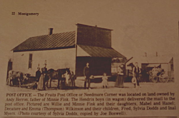
Fruits Corner - on State Rd 25. Ripley Twp just south of SR 32 Sec 12 -- from Jerry T. The Fruits Post Office was located on the land of Andy Herron in section 11 of Ripley Township. His land was on the southwest corner of the intersection of SR25 and SR32. This intersection was known as the Needmore Corner in the 1800's and in the 1900's as Myers Corner.
Gallagher's Gas Well -- Ed & George Grimes - Peter Barnhart, Andrew Gillis were land owners in the area in the 1880-1890s. Located in South Union -- # 275 - Suz got it :)
Garfield - Source: Crawfordsville Star Oct 15, 1885 p2 We hear so many inquiring where is Garfield? For the benefit of our many readers, we will endeavor to locate the place. Garfield, formerly known as Binford's Station is situated in the eastern part of Union Township on the Vandalia RR, three miles west of Darlington and five miles east of Crawfordsville. We have a post office, a dry goods and grocery store, hard ware, & c, one doctor, one music teacher, a fence factory, and other professions too tedious to mention. All we lack is a blacksmith and wagon shop. We have the best of society. New Union Church is a quarter of a mile east and the Quaker church a mile south. Dr. Burk says, out of the many towns he has practiced in Garfield is the most peaceable. on Highway 47 East of Crawfordsville, in Franklin Township just west of Darlington (fSee also - Binford Station)
Garland Cross Roads -- mentioned in several Crawfordsville Weekly Journals in 1899-1900 - (thanks Suz) - probably in Brown Township where several Garland families lived (or Ripley)
Gas City -- 8 Aug 1895 Crawfordsville Weekly Journal there was a “Gas City” news item with Quiggs, Vannice, Pleasant Butler and Harvey Pickens mentioned. Garfield, Darlington and Shannondale were also mentioned and it sounds like it was probably above (toward Shannondale) and half way between Garfield and Darlington but not 100% sure exactly where.
Ghostville -- mentioned in several Crawfordsville Weekly Journals in 1899-1900 - (thanks Suz) - finally discovered that it was in Section 4 Franklin Township with a bit in Section 2, North Union
Gilliland School House - near New Market, likely South of there just a couple of miles. Source: Weekly Argus News May 11, 1895 -- The show at New Market was good and largely attended. Clay Reeves and family were at his father-in-law, Mr. Noble's Tuesday. James Poynts and Mr. Hampton set out 75 different kind of fruit trees last Thursday and had 500 Mulberry sprouts to set out. The election of New Market went Democratic. - (kbz)
Glacier Mound - west of Shannondale - north of Muskrat Creek - (thanks Suz)
Glenwood Park - East of Whitesville - (thanks Suz)
Golden Gate -- found in the Crawfordsville Review Dec 18, 1923 -- Mrs. Sophie Mount remains poorly - Dr. Mount of Kirklin was called to the home of JE Mount to see Mrs. Mount. Mrs. Ruth Charters & Howard of New Market and M/M Robert Clemens and Clarice of Bloomington ate T-giving dinner with M/M Charles Johnson and Clifford & Chester. Series of meetings held at Providence Church closed. Roads in bad condition - so much rain. Skunk & coon hunters are getting plentiful at night.
Goose Nibble - near Milligan Park just off of Mill Street, this area was the section in Crawfordsville where many of the Irish railroad workers lived Henryville - ?? The Junction is between Goose Nibble & Fairfield
Goshen -- Jan 26, 1895 Weekly Argus News (sent from Jerry T) -- lists Virgil Francis fight bumble bees and visiting his sister in Crawfordsville. AM Stewart feeding a large bunch of pigs; Jesse G. Moore called to jury duty; Arnell Peebles gave up blacksmithing; Claud Miller gave up on becoming a cow boy and is now "wielding the razor" in the city of Darlington. Several summoned to attend court in Henry County on the 4th of Feb for the case of John Sexton's murder that took place at Thorntown last fall. - this is obviously in lower Eastern Franklin township, but don't know exactly where.
Grange Road -- see LaGrange Road
Grassy Springs -- Walnut Twp (Source: Pauline Walters)
Gravelly Run -- where Gravel Run School is ? If so, off of SR 34, near 950 in Wayne Township - (thanks Suz) - those named there Dec 11, 1923 (C'ville Review) were Halfred Quigg; L.W. Vannice; Curtis & Bertha Quigg.
Gray's Chapel -- found in Dec 17, 1898 - Weekly Argus News p 5 - people listed Bowman; Spragg; Gray; Musser; Wineland - "Lucinda Wineland was born Jan 7, 1829, died Dec 13, 1898. She was married to Elijah Hallett in 1846. Three children were born to this union, two of whom survive. She was again married to John Bowman in 1873 who died in April 98. Interment at Lutheran Cemetery. - Her tombstone is in Phanuel Lutheran Cemetery in Wallace, so Gray's Chapel is likely west of Alamo just in Montgomery County, possibly in Fountain. Her tombstone is Lucinda Wineland Hallet, wife of John Bowman - June 7, 1829 - Dec 16, 1898. Then EP Hallett is on the stone Feb 10, 1847 - Sept 27, 1908. (Elijah Porterfield)
Great Boulder -- (Preacher's Rock) -- located in Section 34 of Franklin Township. Source: 1878 Montgomery County Atlas - thanks to Kim, Jerry & Tom for help with this one. When they called this the "great boulder" they weren't exaggerating - it is HUGE. (see photo - thanks Jerry). Although we are not sure of a specific church or if there was one, the Hurd cemetery (about a half mile down the road in a patch of trees) indicates there may have been an early one in the area. It is known that Rev. Clairborne Young (born October 29th, 1800 at Stony Creek, Hawkins County, Tennessee) preached on that rock many times. He died in Boone County, Indiana September 9, 1866 and is buried in the Shannondale Cemetery in Montgomery County, having married Mary Russell ni Blount Tennesse (by Isaac Anderson, of course, a Presbyterian minister) October 2, 1827. They would come to have eight children, including Clairborne Addison Young, a poet, who looked just like his father.
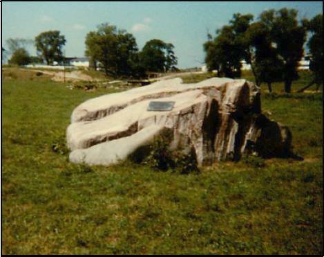
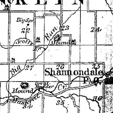
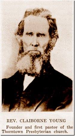
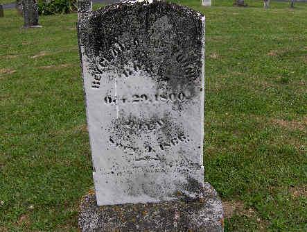
In a biography of him (yesteryearnews.wordpress.com) we learn that the Rev. came in 1831 to the Throwntown/Shannondale area and was sent to organize three Presbyterian churches: Shannondale, Thorntown and Lebanon. "The father was one of the most conscientious of men and this characteristic, with others, the son seems to have inherited." Addison enlisted in the Co. G, 17th with Lew Wallace and became a Capt. in the 85th US Colored Infantry. He, too, became a minister but of the Unitarian faith.
In a history of the Bethel Presbyterian Church of Shannondale it states that Rev. Clairborn Young was called on to preside over a meeting with the purpose of creating a church. The meeting was held near what is now highway 32, and a large rock, where this first meeting was held, has a bronze tablet memorial, which was dedicated 4-23-1969 at 2:30 p.m. at "Rock Church." - the tablet read: "Bethel Presbyterian Church, founded March 17, 1831 by Rev. Clairborne Young) who gave the first sermon here." Original members: James A; Martha A; Susan Thomson; Gerardus Robbins; Atwell Mount (who later became Governor of Indiana) John L. Cooper; and Mary Young. The rock was the pulpit. These folks were "members of good standing (likely with letters from their previous churches) willing to form a Presbyterian Church. Mount and James A. Thomson were appointed elders and ordained at their second meetin on April 3rd. New members soon were taken in - William and Rachel Hill; Barbara Robbins; Jane Carr and William Carr. Lucinda Fullenwider Mount was received into membership on the April 6th meeting. For two years meetings were held at the Robbins School House or at the home of a member. More on the formation of the church on the Church pages.
Note: Sources for this information: Jerry Turner for the 1878 map. Lynne Ream for the Rev's photo (findagrave) and Jon Rice (findagrave) for the photo of his grave. Yesteryear Once More "Clairborne Addison Young." History of Shannondale Church.
Note: Sources for this information: Jerry Turner for the 1878 map. Lynne Ream for the Rev's photo (findagrave) and Jon Rice (findagrave) for the photo of his grave. Yesteryear Once More "Clairborne Addison Young." History of Shannondale Church.
Gregg Stop -- a Cross road stop on the Interurban -- Thanks Suzie - this would have been about 1910
Greenwood Corner - Walnut Twp - corner of 500 S & 775 E
Grimes -- a stop on the interurban between Walnut & Franklin townships - about 1910
Grover -- although I am not exactly sure where Grover is, has to be close (very close) to Tinkersville as in the Crawfordsville Star, 12-22-1893, several of Tinkersville news items are also with Grover (Grover however had many more including that Charity Chesterson took charge of the school Friday afternoon in the absence of Miss Spruhan. James McCormick and wife and Elmer Branch and wife of New Market visisted Jost McCormick on Sunday. "Our Shady Nook" scribe should attend school more often so he will know how to spell mallard flowers and not call them Ballard Flowers. The Cewnter building is being reerected at Tinkersville by James Chesterson. Other names mentioned: Simms; Skaggs; Clossin.
Hamilton's Crossing -- may be in Tipp Co - sevearl of us worked on it but still not 100% positive where it is :( --Source: Crawfordsville Weekly Journal 25 Dec 1873 p 2 -- Donald Brooks who taught at the Stockwell Institute last winter has received a call to take charge of the English Department at Wilbrahan, Mass at a salary of $1,000. – No school at Sugar Grove this week. – Will Dunbar is buying and selling apples, chickens, washing machines, etc. We thought he was a Granger – M.B. Waugh has engaged 32 head of cattle and 45 head of hogs to Miller & Clark of Ohio to go away the middle of February. He gets $5.59 for his cattle and $4.50 for his hogs.
Hampton Spring --Source: Crawfordsville Star Dec 12, 1895 p 8
those mentioned as living in Hampton Spring” are: Charles Oliver, Frank and JJ Oliver, Joe Keys; Charles Wingert has a sale on the 19th then will move to Bloomington, Ind.
Sarah Thompson (Whitesville) died.
Happy Hollow -- now, located on Highway 47 at the edge of the Airport Road. In the Weekly Argus News, Oct 28, 1899 - it states that George Randle and wife of Boone County visited James Randel's Monday night. Will Davidson and family, Mr. Hobson and family of New Ross and Duck Davison of Crawfordsville visited with Zeb Auman's Sunday. Clara Oliver visited friends in Darlington Sunday. Jim McCormick called on James Randel Tuesday.. Will Linn & George Corn built a corn crib for Charles MInnich.
Hard Scrabble - just west of New Ross (pre 1930) -- found names to be Bailey; Delaney; Swiney; Clark and Griffin - north union township in Section 24/25 - thanks Suzie for finding a bit more than we had :) Source: Crawfordsville Star Feb 28, 1878
“Seeing nothing in your valuable paper from our town, I thought it not amiss to give you a few items – situation six miles east of Crawfordsville, our streets are paved with pure mud and decorated with trees, bushes, etc. Our literary is called Mutual Improvement Society. Declaimations and dialogues by small boys and essays and select readings by young ladies and young men. (Last Tuesday’s debate question – Resolved the signs of the times indicate the downfall of the Republic!” Our latest arrival, Jackman Akin and family comes to establish a sorghum factory. All cane growers may expect a reduction in the price of manufacture.
Havana -- In Walnut township - about equal distance between Beckville & Fredericksburg (Mace) - is Havana corner of sections 9/10 15/16. J.M. Walkup, Charles Linn, Strawder Peck, Harry Ward, Roy Morris, Newt Moler were all people mentioned - along with others. Between 1902-1904 in the daily newspapers Havana is a very popular place. Thanks, Suz
Haw Creek -- train station south of Ladoga near the Putnam County Line - also a Haw Creek Church and very small town
Haw Creek Road -- see Bymaster Road
Hazel Valley -- possibly near Lapland - around Sec. 20 - @ least that is where one of the land owners owned land that was mentioned in the article. Also, one of the ones mentioned owned in Sec 18 of Scott which is NW of Lapland. Sec 20 is SW - so maybe Lapland WAS Hazel Village/Valley. (from Suzie B)
Hazel Village - small burg in Scott Township - my town guru, Jerry T is working on finding more info about it :) - it may/may not be Hazel Valley
Headlight - Was so excited – after finding 357 (with quite a bit of help with some friends although I’ve found my fair share – lol) towns and whistlestops in MoCo, as I was looking (Christmas, 2023) for something on this date, I found a new one in the Weekly Journal OTD in 1896 – “Headlight” – top of my head I’m thinking below Ladoga according to the people listed – Albert Martin, sick; David Hicks, 36 hogs with cholera; Wm. Peters bought Al Williams’ farm; Emma Warbitton staying at Wm. Martins; Wm. Peters visited David Hicks; Jesse Hicks visited relatives at Russellville; Jesse and Warren Hicks shucked corn for IN Gott. Wm. Peter and Al Williams attended to business at C’ville; Thomas Clark has rented the farm of Alice Kelsey for $4/acre. Olie and Eva Wilkerson visited Mrs. Nancy Servies Sunday. May have to put Jerry Turner on this one – he’s much better than me finding these places. Note: I also found “Headlight” 18 Oct 1895 in the CWJ – Wm R Maxedon is the new teacher at Fairview; Frank Coons and family Sundayed at David Waugh’s. Wm Peters and family spent Sunday at Wm. Hamptons. Jesse Hicks and sister, Viola spent Saturday night at Albert Seaman’s. Bruce Mahorney will leave Monday for his new home in Ill. He was a good neighbor. A nutting party of five went to O. Wray’s woods Saturday but did not get any nuts: Frank Loren; Claud Crist; Viola Hicks; Carrie Sweet and Lida Swidler. Pleasant time. Bruce Mahorney, father and his father-in-law, Mr. Handle, drove through in wagons to Illinois. Mr. Mahorney is 82 years old and Mr. Handle is about 80. From those mentioned I would guess this would be in Section 25 of Clark Township
Here and There -- although I suspicion this is Linden and it may just be a play on words, vs. an actual place, it did have its own column along with the other towns in the 1899 Weekly Argus News - names: Clouse; Fowler; Harmon; Hole; Thewlies
Heaven's Garden -- probably in Madison Township - Tomlinsons & Otis Thompson lived in Madison Township at the time frame the town is found (1894 newspapers)
Heffnersville -- people found there are: George Westfall in Coal Creek in 1870 & 1880 & Silas Hendricks - thanks Suz
Henry James Hollow - located north of Crawfordsville. The CSX railroad bridge over Sugar Creek crosses this hollow. Thanks Jerry T
Herron School -- Crawfordsville Journal June 1895 -- Miss Laura & Stella Mason are taking music lessons; James Hutchinson traded horses with John Thompson; Kelley Cunningham bought a cow of Putnam Smith Monday. NO idea where this is -- HELP : ) kbz - 1/19/2014 - Jerry just told me that this is definitely in Union Township, just not sure where it's located.
Hester Road -- See Mangus Road
Hibernia - - Located at the intersection of 525 West and Fall Creek Road in Ripley Township. Daniel Gilkey from 1837 to 1840 built a gristmill, sawmill and a distillery on one of the creeks (Gilkey's Branch). In addition he also operated a small carding mill. In 1850 he sold out and moved to Crawfordsville and entered into the grain business. Later another grist mill was operated by A. J. McMaken further down the creek. At one time the Lane Post Office was located just east of where Gilkey's Branch and Fall Creek joined. They also had a schoolhouse for awhlile.
Hickory Corner - existed in July 1898 as the Daily Argus News on the 29th says, "What's the matter with Darlington, Shannondale, Bryanville, Ireland and Hickory Corner? Hav e you all gone to war?"
Hickory Grove -- Ripley Township - unknown location to date 5-23-2013. Well, thought it was in Ripley but Suzie sends me this -- Oscar Tapp (Sec. 10) & Conrads in Sections 1,11,12. This is North of Garfield & around 275E/500N.
Hickory Hill - this is basically Smartsburg but in the late 1800s it was known as Hickory Hill. Thanks to Jerry T the last day of July 1897 in the Weekly Argus News people mentioned in a news article are Birth RIch (he's better); JN Hughes (good steers for market); James Rich (on a pleasure trip); Corn good in the neighborhood; Jack Martin went to Dover; Bert Shaffer holds the tickets for ice cream supper at Fast Creek; Duch Hall says it's hard to get rich during these times but that's his only desire; C.A. Elmore working on Tom Williamson's for threshing season; Roy Trout left for Martinsville for his health; Charley Warren has a new blower on his machine; CA Hall was at Maxinkuckee Sunday; Elmer Hall has gone to Kentucky-
High Bluff -- families here were Ward Youngs, James Britts, Sam Zachary in late 1800s and early 1900s. Thanks Suz
High Point -- High Point was where John Snyder settled near Middletown. Where Snyder's Chapel would end up. The "2nd" church there was just west of 500 North.
Highland --- it was near Prospect & Curtis Streets - but, wasn't actually Crawfordsville @ the timeinformation was found in the Crawfordsville Weekly Journal dated - 22 Oct 1897 - Mr. Collings, Mrs. Hosier, Had a school, East End Chapel, Blanche Hightower, Mrs. McClure & the Wire Factor - it said, the whistle woke everyone up- too funny (from my great daughter, Suzie B) -- more from Suzie -- in 1898, Highland was in the ottom Left Quadrant of Sec. 5, Union Twp -- Source: Crawfordsville Daily Journal Saturday, 29 July 1893 -- There has been considerable said lately about the suburbs of this city, and it may be interesting to our readers to learn something of the history of these places. Now that the places are without fire protection, it is time for the residents to take some action in regard to the matter, and provide means to extinguish fires. The fire company does not seem to be kicking about throwing water upon burning buildings in the suburbs, but the city cannot pay for the use of water, and probably by the meter measurement at that, when the meter would measure water at the rate of sixty miles an hour. There are six suburbs to this city, all neat, pretty places, with cozy houses and happy people. The first suburb laid out was:
Fiskville—Platted by Chas. H. Fiske on August 14, 1888, and lays north of the city.
Hillsdale -- Section 32 of Union Township - on 1878 Atlas.(thanks Suz)
Himes Road -- 700 South (thanks, Suz)
Hog Heaven - Walnut Twp - on 600 South north on 850 E about 1 mile - (Source: Crawfordsville Weekly Journal 5 Feb 1898 p 7 -- "Many years ago John L. Miller and Ed Shepp built a wagon and blacksmith shop here, and when the boys went home at night, they would prop the door with a rail. The hogs in those days ran at large and in the morning when the boys came back to work they would find the shavings utilized for a bed and the shop full of hogs. One moonlight night some youngsters wrote on the door with chalk: “Hog Heaven.” This is how our place got its name.
Honest Ridge -- Source: Crawfordsville Weekly Journal 18 May 1894 p 7 “Bristle Ridge News” – We give Buffalo Ridge scribe credit due for the full explanation of his exact location and origin of the name. We were quite satisfied as to location but why the scribe should discard the old name Bristle Ridge and substitute Buffalo was a mystery Bristle Ridge is one of the historic places of the county and no doubt the origin of the name is well known. A good many years ago when Elder Carney preached the dedicatory sermon of Center Church which is located on ”the beautiful ridge” he said that the bristle bearing animals had become domesticated and that element was a thing of the past and that he would then and there christen the beautiful ridge “Honest Ridge” as the most appropriate name.
Hoosier Corner - not sure where - doesn't give me any hints really - Source: Weekly Argus News May 18, 1895 p 2 -- R. Finch was in your city Saturday. Bruce Morris was in your city Saturday. Chares Pogue is marketing his wheat. J. Walkup is on the jury for the coming tern of court. John Perry will erect the finest wind mill known, soon. J. Pogues & son, Charles was in your city Saturday. Rev. Frank Fox will give all o fhis attention to the church at Ladoga and will not preach at Union Hill. There is a chance for another minister at Union. Sorry to see Mr. Fox leave but wish him success in his ministery there. Since this must be very close to Union Hill, near Mace area.
Horner School - yes, a school and little community in Madison Twp about 3 1/2 miles east of Linden in Section 10
Horse Shoe -- the bend in Rattlesnake Creek where Sections 21 & 27 (South Union Twp.) meet - 150 foot deep cove - 5 miles SW of C'ville. Kennedy's & Wilhites had summer-type cabins here. - from Suzie
Hudson's Bay -- Source: Crawfordsville Star, April 8, 1886 -- found as a town heading like Ladoga; Waveland ... mentioned "David Thewlis who had his house burned some time ago, preparing to build." It evidently is near Linden "canonading at Linden last Monday night was heard." Other comments: LE BUsh' school closed at this place last week. The election at Linden went off finely - TC SHanklin was elected Trustee by a handsome majority...Aaron Layton was elected assessor.
Hunter’s Ridge: Source: Crawfordsville Weekly Journal, Crawfordsville 22 Feb 1895 p 1
The funeral of Chambers Jackson occurred last Sunday at Liberty Church conducted by Elder Trotter. Mr. Jackson was 85 years old and was a faithful follower of Christ, having been a member of the church since he was 22 years old. He leaves a host of friends to mourn his loss. – Same source: “Hunter’s Ridge news item: “ -- David Jackson attended the funeral of his uncle Chamber Jackson at Liberty last Sunday.
Hunt's School House -- since ALL the places on the list of Public Speaking (candidates on the Reform ticket addressing fellow citizens at these places - Crawfordsville Star newspaper, Sept 22, 1874 p 2) agendas were definitely towns (Wesley, New Richmond, Smartsburg, Waveland ....), I am assuming that Hunt's School House is as well.
Hurd's School House -- probably a small community centered around the school in either Walnut or Franklin Twp - found in a May 1881 newspaper - still listed in the town news items April 1886 (D. Elmore is improving his residence. Little Willie Huff has hired to JC Beebe for the summer.
Huscker's Retreat - Usual Linn of Cakers Corner (sic) has commenced boreing for oil, near the corner. The well is now 1200 feet deep and roar of escaping gas can be heard for a great distance. It was power enough to run a 30-horse power engine. He says neve rin his life has he witnessed such an unmistakable sign of a big flow. He is boring a 3" pipe of the gas which enables the people of Mace to read a newspaper after night a distance of 1 1/2 miles. (so, obviously Hucksters Retreat is near Mace) - Source: Weekly Argus News Feb 25, 1893 -- also mentioned is John Elkins will lay brick for Alfred Linn. Frank Armstrong has mumps. Wm. Hankins will move to Lincoln Neb in a few days....
Hutchison Hill -- from the list of names and the other places around it, this is believed to have been on the Scott/Clark township line or very near it. Found in the December 2, 1892 Crawfordsville Star newspaper by Jerry Turner people living in the area are Arch Martin; Wheeler; Huff; McCormick; James Foster; James Robinson
Hymenea -- may be the first in Montgomery County besides Crawfordsville along with Pleasant Hill and Waveland as in 1834 when Isaac Wade, editor of the Record, the first newspaper, it is about the only town that is not in Fountain or Tippecanoe Counties (Wea; Lafayette; Frankfort; Newtown; Attica...) - I had actually heard of Hymenea but had never ran across it technically.
Hyten Corner - Scott Township south of SR 234 - (thanks Suz)
Idaho -- 13 Feb 1875 Crawfordsville Weekly Review -- Letter from Idaho - This place is situated between New Richmond and Pleasant Hill and north of Boston Store. We have a good farming country; land is worth $40 per acre. W.W. Tiffney has been appointed assessor for this township. Eb. Vanscoyoc has purchased a farm and will build a dwelling house next fall. Scroder Roberts will build an $800 barn next Summer Robert Harper says if times weren't so rough he would be a barrel of J.W. Plunkett's hard cider Stephen Ross says that his Kansas cow gives more milk than any cow he ever owned Bluf. Clough is still standing picket. Lee Clines says he don't believe he can ever get the books settled up between Bodey Clough and Henry Banks A.P. Razor has declined having his candy party at this shop, on account of the cold weather. He says he can't mold the candy Wm. Wilhite has the best team in this neighborhood Leroy Hobbs has planted two acres of onions and two acres of potatoes. Simon Wainscott is still trying to bridle his mule. Christopher Laymon has returned home with one dollar and fifty cents in his pocket. (Thanks again Suz - she's quite a daughter :)
Idleywilde--
Imanila -- Found in Crawfordsville Weekly Journal 18 November 1898 -- "Imanila" news -- included names of Finch; Elkins; Armstrong; Kennedy; Loop; Kise; and Mears. No clue where it is even with the names :( Anyone?
Indian Creek - majority of flow runs through Brown Township - Indian Creek Cemetery is named because a contributory of the creek flows on the backside of it
Indian Creek - I had listed Indian Creek for the beginning knowing of course the creek and the cemetery but did not know there was indeed a town known as such -- Source: Crawfordsville Review Aug 31, 1911 p 5 - Indiana Creek, Ind News Items -- "The rain of last week was surely appreciated by all on the creek. Names mentioned - Pope; Shafer; Penn; O'Conner; Doyle and Rush.
Ingersoll Corner - Most NW corner of Ripley Section 3 -- From the Crawfordsville Weekly Journal 22 Feb 1895 newspaper -- "The Ingersoll Corner Sunday school does not boast of the attendance of 100, but she is proud of her attendance and the interest manifested. Large attendance does not make a Sunday school a success." This one cracked me up -- via Suzie -
Iola - was in CWJ 22 Oct 1897. It mentioned a school with 21 pupils, Nellie & Ollie Hipes, Ethel Powel, Newton Powel, Rosa Crain, Joe Linn, Harve Elliott, Rev. Francis Many of these people owned land in Walnut Township - but, this was a difficult one to narrow down. Most of it was near Linnsburg & Mace.
Ireland - existed in July 1898 as the Daily Argus News on the 29th says, "What's the matter with Darlington, Shannondale, Bryanville, Ireland and Hickory Corner? Have you all gone to war?" This little ditty from the newspaper tells more specifically where Ireland is - Source: Crawfordsville Weekly Journal 28 Dec 1894 Mrs. David Stonebraker of Ireland, a suburb of Alamo, gave a surprise dinner at her home Saturday in honor of her husband, it being his 55th birthday. About 50 were present. All went home wishing him many returns of the day. Source: Crawfordsville Weekly Journal Friday, 15 March 1895 -- As some might question the location of Ireland, I will describe it in brief. It is situated in the southwestern part of Walnut Township, has fertile soil and is inhabited by an industrious and intelligent class of people.
Jackman School House - near Young's Chapel - Weekly Argus News 2-14-1891 - names were Griest; Gillis; Hutton; Jackman (obviously); Swisher and Wisehart
Jack's Hollow - North Union Twp. - (thanks Suz) - read here (this was in the Sperry Mill area of town what is now Lafayette Avenue, where we used to go out of toward toward Lafayette (goes by the ball diamonds just north of town). Read more here on how it got its name. Under "Jail - first built & problems, etc"
Jamestown -- on Raccoon Creek on the back side of the old Otterman farm (Northeast of Ladoga) - in 2013 it is property owned by the Sam Mahorney heirs - thanks muches to Bill Boone for this one :)
Jim Davis Bridge Road - lower end of 600 West
Jimtown Road -- 136 throughout Montgomery County
John Bell Road -- south of 32, north of Wilson School Road (200) - thanks, Suz
John Kincaid Lane -- part of 950 South (thanks, Suz)
“Johnstown” news- names mentioned John Zachary (low with typhoid fever); match factory at this place will soon be running full blast; Home Burk near here became overheated; other names: McNelty; Parks; Cox; Ferguson (brickyard); Wilkinson -- Source: Crawfordsville Weekly Journal 10 Aug 1900 p 7
Junction -- The Junction is between Goose Nibble & Fairfield - although it was technically the junction of the railroad, there were houses and I believe a sign saying, "The Junction."
Kellison School House -- Source: Crawfordsville Weekly Journal 23 Nov 1900 p 1 – usually only towns with correspondents have these little bolded names and information about the people who lived there but not sure if this is a literal school house – don’t think so or an area – counting it as a “town” - names mentioned SD Kellison (sold 13 thoroughbred Chester White gilts this week); Jim Jackman; Len Petro; Staley; Clevenger; it mentions Campbell’s Chapel and a meeting and Fiddler’s Point so the area, town, place may be near there
Kemp -- close or the same as Fraley's Hill on 1000 East - thanks to Alice Mc; Marty J and the 1984 Montgomery County Atlas. Anyone know more about this one, let me know :)
Kentuck - See Bristle Ridge
Kentwood -- Source: Daily News-Review July 5, 1900 p 2 -- people mentioned - Miller; Hauk; Hayes; (Hauk's parents); Harshbarger; Mason; Work; Moore. Horn; Jones - this is somewhere close to Waynetown.
Kickapoo --- Sec 13 area of S. Union & Sec 19 area of Walnut - 300 S area - W & SW of Linnsburg - mid to late 1890s for sure - names that appear in the area are: Crain; Linn; Martin; Berry; Hipes; Hall ...
Kimler Corner -- Crawfordsville Star, Oct 25, 1883 -- "under Sutton's Ford" -=- It is reported that Ed Eshelman will open a butcher shop at Kimler corner. thanks Jer
Kimble's Cross Roads -- Crawfordsville Star, June 8, 1882 (thanks muches to Jerry Turner) -- A. Elmore has been repairing bridges the past week; Billie Rhodes sold his farm near Boston Store and will locate in this vicinity; Harry Pickering was at the Cross Roads - he likes to hear the Martins sing; A. Ammerman is building a new picket fence around his green house in Bursonville; James Hurt and Miss Allie Hutchings attended the ice cream supper at Mace last Sat. Sherman Trout took two ladies courting and lost one to another fellow (loved that - shortened a little, but you get the picture). Oscar Sutton almost capsized in the might deep while coming to see his ladylove. -- according to these names, I'd say this is probably in upper Ripley or lower Wayne; however, a couple of the names are Franklin Twp. people ... hmmm ! Anyone know for sure, let us know :)
Kingsley's Chapel -- in northern Walnut Twp. The Land owners I found had land in Sections 3/4/5 & 17 & in Southern part of Franklin. Some of them had land in both Townships. The Franklin Twps were 34 (which is 2 Sections West of Shannondale)
Kirkpatrick -- Madison Township platted 3-28-1882, one of our "younger" towns - it is about gone now, though - (Thanks to Becky Barclay who tells us a bit more - "Kirkpatrick is located on County Road 450E between 1100 North and County Line Road at the Nickel Plate Railroad. In its heyday there was a bank and a coal and water stop. Today, it's a privately owned grain storage facility.
Kirkpatrick Station -- this could easily be Kirkpatrick but when the railroad came through they tagged it with a station behind. Not sure - but in the Darlington Ech August 1898 -- "JW Kirkpatrick of Kirkpatrick Station telephoned over here for Sam Martin to come over as he wanted to transfer a portion of his land to his 3 children. Accordingly, Sam took VB Craig as notary and went out Tuesday morning and made each child happy in the possession of a good farm worth some $10,000 each. THe old gentleman retained one thousand acres as a nest egg for himself."
Kirktown -- May be a different name for Kirkpatrick, but in old newspapers (1880s) it was simply "Kirkpatrick." Madison Twp. Thanks Suzie B!
Klinesville -- see Clinesville
Knowledge Point -- On the last Saturday in September, December,March and June the Horse Thief Detective Association met here but not sure if this is in Fountain or Montgomery County - most of the listings in the old newspapers were from Montgomery so assuming it is here. (C'ville Star, July 19, 1883)
Knoxville -- February 1875 --- very little info - I'll have to keep my eyes open for this one -- Where is Hunt's school - might be near there? It mentions there was a spelling contest @ Hunt's school last Monday. (from Suzie)
Ladoga -- Clark Township platted by John Myers, 3-26-1836 -- read a nifty narrative following the streets of the town by Bill Boone - thanks so much for sharing this Bill - now, if I could just get busy doing that for Waveland, my hometown :) See also Ladoga Photo Album (mostly via BB but a few from elsewhere :) and the Ladoga Canners site of Bill's - nifty site :) A good lengthy article about the early town - set up; businesses; movers/shakers
LaGrange Road -- 200 West to 275 West off of 150 North (thanks, Suz) -- the "Grange" area - or where the Horse Thief guys hung around. LaGrange road is where the radio towers are and he said it would eventually run into Breaks school -- thanks to Suzie B & Dave W
Lake Holiday -(not really a town, but an area) -- privately owned subdivision on County Roads 400 W & 550 S. near New Market, Indiana Lake Waveland Recreation Area - found on Highway 47 just West of Waveland, Indiana
Land of Linns -- Walnut Township (Source: Pauline Walters)
Lane -- Ripley Township (according to the 1878 Montgomery County Atlas - I'd never heard of it :) KZ- Suzie added to this one with its Post Office openings & closings -- opened the first time on 2-8-1870 closed 9-5-1876 then just after it reopened 10-25-1876 and closed 4-18-1878. It barely made the 1878 Atlas then -- heehee :) -- this from Jerry T -- was the Post Office in Hibernia just southwest of Yountsville on the old Alamo Road and now called the Fall Creek Road.
Lane Road -- north east of Brownsvalley, northwest of Penobscott
Lapland - an almost extinct small town lying on US Highway 231 due North of Parkersburg
Larsh -- D.H. Gilkey refers to Larsh in this way - "the most remarkable and interesting affliction that ever came from fight, was under my observation. The children at the township school in the Larsh neighborhood, just below Yountsville, away back there 30 years ago, were annoyed at the noon hour by a drunken Mexican greaser, a painter by trade and a well-known character about Crawfordsville, where he made his home. He was a hopeless inebriate and while working out in the country had gone daft for a drink; had an acute attack of mania potu, I suppose. When I saw him he was on his way to town with an order for some goods and he was wild for liquor. I urged him to go on to town and I thought he had acted upon my advice till after school was opened and a class was up for spelling. The door was open and as a child cried out, "Look, Pedro has cut his throat!" I looked upon the form of the greaser lying across the door step, a knife clutched in his fingers and the blood gushing from his neck. The brightest boy in my class, one that never did get spelled down, was beginning to speall a long word of four syllables when the child cried out. His knees shook, his eyes became glassy and he almost fained, and to this day he an hardly spell dog without a tremor that he can't account for at all and yet he is one of the brighten men I know of in all my acquaintances, and is on the road drawing a big salary as a traveling man. Old Pedro didn't die, but was taken to the poor farm and while there strangled to death while trying to take a drink of water. That knife cut had disorganized his windpipe." - thanks Jerry T.
Leiter's Ford -- kbz - Source: Darlington Herald newspaper 12-20-1918 A death which brought sadness to many Darlington homes, was that of Charles Elmer Hiatt, known as "Doc," which occurred at his home in Leiter's Ford Monday night at 9 o'clock. -- this might possibly be in Boone - still searching it :)
Lewistown -- on Juine 2, 2017, I was talking to one of the older citizens of the Waveland area (Dale Simpson) and he said he'd heard I was collecting towns. Said he bet he knew of one I didn't have. At 453 I thought no way but Lewistown I did not have - do now, it's 454. Thanks Dale. This would be going towards Crawfordsville from Waveland a little over half way on the Waveland Road where on the left side there is an older home spruced-up by the Amish, 3 or so newer homes and a small cottage-type home where in 2017 Jim France lives. This is where the town was - a small one of just 4-5 homes - early
Liberty -- Weekly News Review Jan 5, 1901 - not sure if this is the same as Liberty Chapel or a different area; however, it is near Waynetown (possibly between it and Alamo) according to the names in the above newspaper (Petro; Utterback; Swank; Quirk). Thanks, Jerry T :)
Liberty Chapel -- On the 4th Saturday in February, May, August and November, the Horse Thief Detective Association met her - sure there was at least a church and school there in the late 1800 - early 1900s. In northern Union township area.
Liberty Hall -- 1895 Crawfordsville Daily paper lists names such as Moody; Edwards; VanScoyoc; Armstrong; Peterson; Harris; Linn. This would be somewhere near Mace in Walnut Township, but no clue where - HELP on this one everyone :) kbz
Liberty School Road - 800 South / 600 West
Linden -- created 2-12-1851 Sec 8 Madison Twp by Joel Lee, William Hartman and Hi Hughes - located on US 231 North of Crawfordsville. Come on you Linden folks, send some pics in :) Need a Linden photo album (-- See Bill Boone's Bulldog site - it's nifty
Linnsburg (station) -- 5-25-1870 Walnut Twp Sec 18 -- platted by a woman, Susan McMullen -- note from Jerry Turner on 9-21-2013 - thanks for the addition info Jer -- The current towns of Mace and Linnsburg used to be called the twin “cities” of Montgomery County because they were within a half mile of each other. The current town of Mace was platted, February 4, 1838 by a circuit rider named Frederick Long. The original name of the town was Fredericksburg. The railroad came through in the 1850’s, about a half mile to the south of Fredericksburg. The intersection of the railroad and the north/south road became a railroad station and water stop called Mace Station. A village grew up around the station and on April 25, 1870 was platted as the town of Linnsburg by Susannah Fender Linn Mullen. The name of Linnsburg was chosen because of the all the Linn’s who lived there and Susannah was a member of the Linn clan. Asbury Linn owned a big general store around 1907, George Hugleheim had a blacksmith shop just south of the railroad. The small town even had a central hall, Linn Hall, where entertainment was held. A creamery was located across from the depot, a stave manufacturer, a wood turner, and the Connor sawmill. A grain elevator also existed there at one time and a Post Office existed from 1864 to 1918 . In 1873 the railroad changed the Mace Station name to Linnsburg Station. In 1913 the people of Fredericksburg decided to take the name of Mace for their town. Mace had a blacksmith early on, named John Hanley, David Crain was the first wagon-maker and a cobbler by the name of Elias Crain. Several merchants kept shop there since it was on the Indianapolis to Crawfordsville road and the stagecoach occasionally stopped there. At one time a large two story brick school house was located on the southern end of Mace. .
Little Bill No 1 -- Source: Crawfordsville Star, Thurs, Nov 8, 1883 -- Sam Hipes is building a corn crib. Dr. Joseph Ward is stopping with J.M. Martin. John Peterson will locate in Putnam County. Grandpa Peterson was at H. Loops on Sunday. Dan Woolever failed to materialize at the hog suit. S.V. Smiley has moved to the JP Shop farm. Josephus Vanarsdall of Decature County is visiting here. Shepherd and Shadick are holding forth at Bald Hill. Cyrus Tomson of Noblesville has settled at South Mace. Ferdinand Willis of Lotus is stopping at J.B. Wainwrights. Source: Crawfordsville Star, March 2, 1882 p 5 - "Little Bill" -- Our village lays south of Mace and takes its name from one of our most extensive manufacturers, Wm. Galloway, who is a farmer and blacksmith. Marion Leak is our trapper; Obed Galey is our carpenter; George Smith, practical farmer; Capt. Eradie Allengood, wood chopper; J.W. Strong runs a wood saw; Arch Martin, superintendent of gravel roads; Hig Brenton, ass't supt; Williams and Hugelhemner, jail inspectors.
Little Egypt - Madison Township, between 200 W & 150 W - (thanks Suz) --South half of Sec 6 - which is the MOST NW section near Coal Creek & Tipp. County. There was a railroad & Creek going thru this section.
Little's Corner -- Sections 11/12 of Ripley Township. It is also close to where Ridge Farm Sunday School/School were - thanks to Suzie :) 23 Dec 1904 CWJ Little's Corner (Ripley Twp. Sec 11/12 - Fruits Cemetery area). "Several butchered last week. Andrew Thompson has sold his turkeys and will not raise Christmas meat hereafter."
Little's Mill -- Source: Crawfordsville Star, April 26, 1877 p 4- For the information of the stock breeding readers of the Star, we subjoin the names and locations of Horses and Jacks for which we have printed bills this season: ...."Red Buck is from the original Red Buck will be kept by A.W. Herron near Little's Mill and at Alamo." - 445th town - unbelievable !!!
Locust Grove - in Coal Creek Twp, 6 miles Northwest of Crawfordsville -- Post Office 3/8-1847-11/21/1855 - still in existence in 1860 as it is on a Colton map -- Source: Crawfordsville Review 19 April 1856 p 3
Locust Grove Post Office – The Post Office at Locust Grove in this county has been discontinued by the PM General because no one in its vicinity was willing to act as Post Master. All mail matter for that office, will, hereafter, be received and delivered at the post office in this place.
Lofland Crossing - Weekly Argus News, 2-17-1900 - "Everybody in the vicinity takes the Argus-News" - this makes it a little hard to distinguish exactly where this town is but likely in lower Madison Twp or upper North Union.
Log Cabin Crossroads -- Montgomery - Boone County line at 100 South - Walnut Twp (NE) - (thanks Suz)
Lone Tree -- Crawfordsville Journal - 1897 paper in the "Lone Tree" article, the names of these people were listed in the "gossip column." Mrs. Sidener; Will Hopping; George Hopping - loved this last name :) Wm. Swearingen; Mr. & Mrs. Biggs; Harry Shanklin; George Shanklin; Andrew Thompsons famil;y Florence Demoret Dan Morris; Frank Thomas - most of these names can be found in the 1898 Atlas in Ripley Township (upper eastern corner). The Hoppings lived in Section #4 and #6 in Ripley Twp. In February 1897, Caroline Jane Groendyke Breaks was listed as passing away in the "Lone Tree" paper articles (Crawfordsville Weekly Journal)
Long Branch -- mentioned in several Crawfordsville Weekly Journals in 1899-1900 - thanks to Suzie
Longstreet -- Northwest of Shannondale Section 13 Franklin Twp -- landowners of the area were Knox, Deck and Jewells. - thanks Suz & Tami :)
Longview -- portion of Crawfoardsville on the West side -- platted by Peter S. Kennedy; William Brush and Henry Talbort on 8-2-1873 (thanks, Suz) -- Encompasses north from Wabash Avenue up to Main including Vine & Barr Streets
Loop's Crossing -- Beckville area –names (from Crawfordsville Weekly Journal 1-3-1896) include: Frank Cogle; Eddie Mills; Carl Loop; Will Pittinger; Leaton Loop
Loverhill -- From the list of people who lived there (Crawfordsville Star 9 March 1894 - thanks Jerry T) this would be about 3 miles south of Crawfordsville in Union Township, near the small village of Tinkersville. This is where Johnson McCormick was born and Jim Foster called on him Sunday afternoon - Alice McCormick spent Thursday at her brother Jim's; Wes Burk and wife spent Tuesday with home folks. Misses Eva Clossin and Moore were in our midst Friday. Mr. Monroe called on Grover Scribler. Polaman Skaggs walked all the way to town Saturday. Charley Baldwin is on the sick list. Pearl McCormick is visiting her sister Emma Burk. Miss Ella Moore has quit school (probably Shady Nook) because of sickness.
Lover's Hollow - This is basically Garfield (Binford; Cox; Sands; Woliver; McCoy and Conrad are families there in June 1897 from Weekly Argus News)
Lover's Lane -- Clark Twp - below Ladoga on 900 South in a crook of the road :) And, don't look at me, I never went there :) kbz
Lovers’ Knob – Crawfordsville Weekly Journal 24 Jan 1896 – an article for the town of “Lovers’ Knob” talks of John Vannice being sick 7 more weeks of school; Ennie O’Connor returned from Indianapolis. Mock trial at Hurd’s School House on Jan 29th. Charles Warren of Smartsburg is husking corn for Joe Slaves and Jack Hughes & John Connor put up 22 loads of ice last Tuesday and Wednesday. They say they’ll live “cool next summer!” Probably same as Lover’s Hollow ? Certainly in the same area!
Lowland -- from Suzie - Walnut Twp, Sec 5 -- Finch and Coons families lived in the area -- Oct 8, 1898 Weekly Argus News mentions Jasper Weaver; Wm. Linn; John Wards; Jake Caster; Samuel Ward; Homer Linn; Finch; Fletcher; Morrism Calhan.
Lutheran -- from Suzie - this might possibly be just over the Montgomery line into Boone where the Lutheran church is on the corner of the curve but until I find out for sure, we're countin' it :) Let me know if this is incorrect - In the 21 Feb 1914 Crawfordsville Daily Journal p. 8 Lutheran (Near Darlington) The sick are improving. There was no church here Sunday evening on account of the severe snow storm. Rev. E.P. Conrad spent over Sunday with Bert Hampton and family. Mrs. J. M. Davis was in Crawfordsville Tuesday. Mr. and Mrs. Claude Haffner of Jamestown were here last week visiting Fred Haffner and family and other relatives. George Faust and family spent Monday afternoon at Albert Black's. Mr. and Mrs. Voris Slipher of Thorntown were at J.D. Coltrain's on Tuesday.
Lye Creek - runs through upper part of Sugar Creek Township flowing into Sugar Creek - received its name because the color of the water was that of lye (1878 atlas)
Mace -- in Walnut township -- near (really, connecting with) Linnsburg, Indiana. This information was added by Jerry Turner - 9-21-2013 -- The current towns of Mace and Linnsburg used to be called the twin “cities” of Montgomery County because they were within a half mile of each other. The current town of Mace was platted, February 4, 1838 by a circuit rider named Frederick Long. The original name of the town was Fredericksburg. The railroad came through in the 1850’s, about a half mile to the south of Fredericksburg. The intersection of the railroad and the north/south road became a railroad station and water stop called Mace Station. A village grew up around the station and on April 25, 1870 was platted as the town of Linnsburg by Susannah Fender Linn Mullen. The name of Linnsburg was chosen because of the all the Linn’s who lived there and Susannah was a member of the Linn clan. Asbury Linn owned a big general store around 1907, George Hugleheim had a blacksmith shop just south of the railroad. The small town even had a central hall, Linn Hall, where entertainment was held. A creamery was located across from the depot, a stave manufacturer, a wood turner, and the Connor sawmill. A grain elevator also existed there at one time and a Post Office existed from 1864 to 1918 . In 1873 the railroad changed the Mace Station name to Linnsburg Station. In 1913 the people of Fredericksburg decided to take the name of Mace for their town. Mace had a blacksmith early on, named John Hanley, David Crain was the first wagon-maker and a cobbler by the name of Elias Crain. Several merchants kept shop there since it was on the Indianapolis to Crawfordsville road and the stagecoach occasionally stopped there. At one time a large two story brick school house was located on the southern end of Mace. . Update 1-21-2014 -- we think that Mace was found as Macedonia a few times in the old newspapers - what a hoot! Wonder if it is actually its name ? Hmmmm. Suzie also found this bleep and by the way a Kite Track is a harness racing track with only one turn - thanks to my C'ville FB pals for the answer to that - yippee. Then Marilyn from my Montgomery GenWeb group added this tidbit -- In harness racing, the first tracks were one-mile long kite shaped affairs, beginning and ending at the judges' stand - see below :)
In the CWJ 1894 it says under Macedonia ... Clifton Linn will make some improvements in the Bowman kite track and smash some records the coming season.
Madison Township - in northern center of Montgomery County - Linden is its main town. From the 1878 Atlas of Montgomery County : "The surface of Madison is level. Portions of Six-Mile Prairie and Potato Creek Prairie and the whole of Lye Creek Prairie are located in this township. Lye Creek Praire was formerly a lake and swamp, but by a system of drainage, the land was made arable and will soon be as valuable as any in that neighborhood. The Lye Creek ditches drain the water through Lye Creek into Sugar Creek and a system will probably be completed this year draining the west part through Black Creek into Sugar Creek. Land in this township was bought in from the government as late as 1850. The quality of the land and the averages per acre are the same as in Sugar Creek Township. Of old settlers there are: Joel and Orin Stoddard, 1830; Abner Cox; William Rice, one of the first school teachers in this part of the county; Jhn Kern, 1829; William Mathews; Jeremiah Miller; Elijah Thompson; A. Campbell and John Kerr. Linden is a small village on the LNA & C Railroad on the southeast corner of Six Mile Prairie. The shipments of grain from this point are very considerable as it is the center of trade for a radius of 5 miles all around. It has a daily mail, and all the conveniences of a good sized country town. Cherry Groves is only a switching station on the railroad named.
Magnolia Mills - Ripley Township, Sec 36 - 525 South - 800 West -- Joe Showalter on the Crawfordsville Facebook page says, “I was down that way today. When the creek is low you can see the hand hewn beams for the wooden dam at Magnolia Mill. William was Elijah Clark’s son. Elijah built the 1st mill on that site in 1840. The original mill was 4 stories tall.” County Road 675 West. Road used to connect to Clark’s Mill Road on which there were two fords. 1-17-2020
Manchester -railroad stop on State Highway 231 north of Crawfordsville - before Cherry Grove - extinct - Jerry Turner sent more on this place -- Note on Manchester, first appeared as Shirley Hill on Monon time table March 31st 1901. It became Manchester on May 1st 1904. Along the Monon rail line it was mile post 144 and elevation 753.
Mangus Road -- 200 E (also known as Hester Road) - thanks, Suz
Manson Hill -- North of SR 32 - South Union Twp - (thanks Suz)
Maple Corner -- not sure of this is just another name for one of the maples below but may be different -- I actually saw it in another year or two but thought I already had that town so ignored it but today, I thought I best look and lo & behold there is no Maple Corner per se we have listed so -- Source: Crawfordsville Weekly Review Dec 15, 1910 p 8 - Maple Corner news - Frank VanCleave purchased a milch cow at Mr. Botts' sale Monday. There was a good attendance at the sale and all article brought a good price. Other names mentioned were Ben McMain; Coons; Gohman, Sim Rice; and this is really cute: Mr. McCullough was shot by a hunter a few days ago as he was feeding his hogs. The hunter took a shot at a covey of quail and hit everything but the birds, including Mr. McCullough. The latter chased the nimrod but he escaped. Mr. McCullough learned who he was, however. Only a few of the shot struck Mr. McCullough and he was not seriously hurt.
Maple Grove -- NW corner of Clark sections 5 & 6 & the SW corner of Walnut Sections 31,30. Some of the land owners: were Imel, Corn, Himes, Linn, Everson - from the 1895 February Crawfordsville Weekly Journal - thanks, Suzie
Maple Hill - seems to be on the west side of Elmdale - Widener & Coons are names mentioned (January 1905). Sec 30/31
Martin's Crossroads -- in the south section of Coal Creek Township (thanks, Suzie)
Martin's Crossroads - we believe there are two by this name but could be one and we've gotten them mixed with each other or Martinsburg - we'll keep working on 'em :) North part of Walnut (sections 3,4,5 & 6) & the South part of Franklin (sections 32, 33 & 34) Names: Hutchings, Caster, Trout, Craig, Ellmore, Martin - thanks Suz
Martinsburg -- I'd love to find this one as I had never heard of it until recently and have NO idea where it is
Max – Source: Crawfordsville Review Feb 8, 1912 p 3 -- Clyda Runyan of Max was buried at Pisgah (under Beckville news, so assume it is in that area) Source: Crawfordsville Review Feb 8, 1912 p 3 Mrs. Clyde Runyan (nee Rogers) of Max, was buried at Pisgah cemetery Sunday. She was well known here, being a granddaughter of Mr. and Mrs. Wick McLaughlin.
McBee Corner - (Potato Creek Church) 575 E 900 N in Sugar Creek Twp - thanks Suzie B and Dave W
McCabe Corner - west sideof South Union Township - (thanks Suz)
McClaskey's Corner - near Darlington - existed in 1875 (near Buchanan's School House - it is mentioned in the direction for a fox drive to be on the 12th of Feb 1875 (9 Feb 1875 C'ville Star newspaper)
McCrea Corner -- mentioned in Phyllis Waye Boone's New Richmond, IN book. Likely where Edward T. McCrea lived. He was born in Shelby County, Indiana April 20, 1836, was in the Civil War. In 1867, he settled in Coal Creek Township. He married Jessie L. Draper July 30, 1867 and they had at least three children: Ed; Wm and John.
McDowell Corner -- Madison Twp, west of Kirkpatrick - (thanks Suz) - intersection of CR 1100N and CR 350E taken today. - thanks to Jerry T. for the awesome picture of the monument at McDowell Corner - click on the name in blue and you can see this super picture
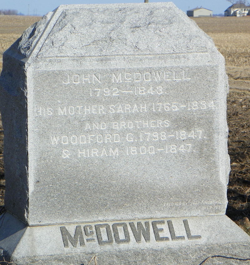
McFarland Ditch -
McKinley - may be same as McKinley Hill but don't think so - anyone ever find out, let me know -- we discovered 3 towns in this article -- Source: Crawfordsville Review 17 February 1894 -- News items under the title, "Smokey Row" - Union Township - names included in the news article - Clossin; McCormick; McKinley; Monroe; Newland - at the bottom of the little items there was this -- Smokey Row is bounded on the north by Mt. Tabor the east by McKinley - west by Otterbein (first thought this was Otterbein in Tippecanoe County but it can not be but might be why this town must not have existed long) and south by Whitesville. Since Mt. Tabor was at 150 South and 200 East in today's world and Whitesville 500 S and 400 E it likely was it was evidently in about the 200-400 range South and ? on the East - pretty exciting
McKinley Hill -CWJ Jan 31, 1897 South of Darlington, West of Shannondale - mostly around sec 29 & sec 30 of Franklin. Peebles, Hall, Vannice, Sutton - szb
Meharry Grove -- from a Montgomery County Magazine July 1976 article -- There were meetings, religious and political there in the 1870s - probably in lower Coal Creek Twp - it was on the north fork of Coal Creek south of a covered bridge at the time. (via Suz). Suz sent more information on this one -- For over 30 years, this was an area to camp in - on 40 acres in Section 3 west of the Meharry Cemetery. It is 1 1/2 Miles north of Pleasant Hill (Wingate)
Mendenhall's Corner -- Source: Crawfordsville Weekly Journal Crawfordsville Montgomery County Indiana 31 January 1896 p6 -- Mendenhall’s Corner – names mentioned in article are: Quick; Patton; Parson; Moore; Brown . Sounds from these names it is up in the New Richmond area ? Anyone know, let me know - kbz
Merry Widow -- an Interurban cross-road stop - this was also called Akers (Suzie wondered if Mrs. Akers was the merry widow?) - about 1910
Metropolis Mill -- see Troutman
Mexico – upper northeast part of Montgomery County – found in an 1837 tourist map of MoCo found by Jerry Turner
Miceville -- news items – people listed are Ambuster Williams, George Duke, Homer Chambers, George Clark, Henry Roberts, Guy Evans, George Mears, Angie Zinbe and Crazy Conner, not sure that’s a nickname or a comment on his mental condition. There was also a notation that the applications for graduation at “Center” are Eliza Bowman, Jane Chambers, Bertha Peterson and Bert Peterson. No particular indication of where this was.-- found in: Source: Crawfordsville Weekly Journal 9 march 1894
Middle Fork -- only place we've seen this "town" is in the Weekly Argus News on 10-28-1899.when it said, "Charles Campbell, Tom Dunbar and wife and Bessie Brown attended the commencement at Middle Fork Saturday night. Asuming this is in Montgomery County? Thanks to Jerry T.
Middletown - Although no confirmation, pretty sure this is a railroad stop. Some say it was what Waynetown is today (this was just confirmed 1-29-2013 via the 1878 atlas which lists Waynetown (Middletown, first called) p 11 -- Added 8-20-2011 -- Dear Karen I was looking at the old places in Montgomery County,Indiana , Localities. And found Middletown ,you have as a train stop but it was an U S Mail stop. Between Louisville and Chicago. There was an air field south of the school house . The air field run east and west from State Highway 25 to road running south out of Waynetown . Regard Russell Perkins . Little more to add on this town, in 1864 there are several businesses listed in Middletown but think some of these are likely in Waynetown -- names are: A.F. Moore; Isaac P. Murdock; S.J. Green, physicians - Joseph Henry and William Holder Cabinet makers & Undertakers except Holder is also listed as Hotel Keeper. Blacksmiths: J.M. Hoffa; R.E. Ellis and E. Oswalt (who lived 3 miles SW of Middletown). K. Bain was a pumpmaker. John Moore, 3 1/2 miles SW of Middletown is a shoemaker. J.D. Smith, wagon maker. JP's were EJ Baldwin and A. Bunnel with D. Merrill the Township Assessor. To add to this information there are several farmers in 1860 census (for Middletown, Wayne Township) born in NY (might be interesting to find out if they came together) -- Quick; Hays; Vaughn; - some from Kentucky and Ohio (Baldwin; Moore; Potts; Shanklin; Utterback; Hauk; Blankenship; Tracy; Harlow) and a few from Pennsylkvania and Maryland (Thorn; Wilhite; Rhodes; Moore); others Virginia (Utterback; Kerchievial)
Midway Plaisance -- # 300 -- Found by my wonderful daughter, Suzie Zach Baldwin, Local History librarian at the Crawfordsville District Public Library -- Here's what she sent from the Crawfordsville Weekly Journals of 1894 -- West of Kirkpatrick - North Middle of Madison Twp. - Mostly sections 3,4, 9 & 10 Fraley, Halstead - another cool thing mentioned "The skating rink is the center of attraction now in Linden. It is really surprising to note the interest some of the mothers, grand mothers and great grandmothers take in learning how to skate. It brings forcibly to mind the old adage. "better late than never." and "never too old to learn." in witnessing their perseverance in the new branch of education. WE sincerely hop0e that success may continue to crown their efforts. As the rink is directly over the post office one would imagine on going in for mail that the World's Fair was still in progress and that the racket overhead was only the camels trotting around through the principal streets in Cairo."
Mill Creek -- This was probably in either Coal Creek or Wayne Township near the Fountain County border as there is a Mill Creek there
Miller Creek -- Crawfordsville Star, June 3, 1897 -- lists items under Miller Creek - corn plowing is the order of the day. Mr. and Mrs. Bert Breaks are the happy parents of a daughter. A number from here attended the Sunday School convention at Mt. Zion last Thursday. Anna Long, George Largent and P.M. Buck were guests of Pearl Lofland Sunday evening. - thanks Jerry - likely near Breaks school area.
Miller's Hill -- although I do not know exactly where this place was, it obviously is near Smartsburg. where a church used to be. There is one house near there (west) yet today that used to be either a church or school - perhaps it was there? Anyone know, let me know :) Source: Daily News-Review Aug 1, 1900 p2 - Ed Welch goes to New Richmond every two weeks to see his $8,000 girl. He distubs Jim Coleman on his way home. Ed Welch takes his daily walks every morning and evening west of Smartsburg. The Dr. says it will be good for his health if he will be good for his health if he will be careful and not eat too many plums. Mrs. Allen Robertson says Allen gets in before dark every night for fear he will see the mammoth snake. Stella Kennedy has taken Ed Welch to raise. She says Ed is all right. Emmet Sutton sold a fine lot of hogs last week. Paul Lynch is very low with inflammatory rheumatism.
Milligan -- in 1898, Milligan was in the bottom right quadrant of Sec. 5, Union Twp & - thanks Suz - this may or may not be the same as Highland - they are at least extremely close. It is not the plat where Milligan Park is and has been since its inception.
Mills Corner -- 1985 -- C'ville Weekly Journal 12 July 1895 p 6 -- Mills Corner news article has Loop; Christy; Kelly; English; Ferguson; Henderson; Airhart; Bratton; Bowman - so I'm thinking it puts it in the Darlington / Bowers area
Momence -- Source: Crawfordsville Star 13 July 1882 p 5
Mace people will be curious to know where Momence is and of its surroundings and history. Momence is bounded on the east by Coxville, south by Tiger Valley, north by Flag Creek, west by Smartsburg and takes its title from the large family of that name who have recently located here from Chamberlin, Illinois. It is in the heart of the great wheat belt of old Montgomery County. Land here is worth from $00 to $00 per acres. Our folks are well-to-do farmers and do not emigrate to the western wilds; but instead, people from the west come here to settle as will be seen by the number of Momences. Messrs. Echelman and Vitz also of Illinois have settled here. There are many prehistoric and natural attractions here of which I will speak in my next. (same article titled “Momence”) – If Fred Momence fails to get the PO, he will likely accept the position of foreman in the coal mine of RC Craig at Liberal, Mo. Chamberlin Momence has returned from his visit to the Sucker State where he has been looking after a small farm which he has largely planted in potatoes. TW Sutton and Fred Momence will likely be the contractors on the new Momence Chapel to be built this season by the ME Church of this place.
Monon Crossing - sneaky suspicion this is the same as Monon Flats since there are Chestersons in both places but the Crawfordsville Weekly Journal 7 Oct 1898 p 2 calls it MONON CROSSING. Bert Chesterson of Putnam County was visiting. Frank Gray sold his mare to Walter Brothers for a good price. Mrs. George Chesterson and son Frank went on a visit to Illinois to see Frank's best girl. Uncle George Chesterson sported a new surrey and the wheat looked good while the corn was all cut - kz
Monon Flats -- Weekly Argus 5-27-1893 -- news from Monon Flats included Lizzie Clossing on the sick list - Bert Chesterson working for Harve Britton this week and Alice McCormick & Son were guests of Ida McCormick on Thursday.
Moore's School - see Pine Grove
Morris Switch -- Source: CWJ 1 June 1894 p 9
“Morris Switch” – Thomas Clifton holds the red light and stops all trains here at night. The new bridge is in and is a beauty. Other people mentioned: Mrs. Jonathan Zook is very sick – Gen. Lew Wallace passed through here Sunday on horseback. We boast of nothing this spring but pretty girls – lots of them. Miss Lulu Stout will render some sweet music on the organ Sunday assisted by the YPCU choir. Misses Vernie Viers and Florence Boraker will superintend the decoration of Mt. Zion Chapel Saturday evening. Dan Cahill, the man who works the ropes on the traveler at the new sugar creek bridge served three years on board the US Flag Ship, Tennessee. Three of the Yountsville Star ball tam live here, namely George Howard and Harry Shanklin (sic just two). The Stars won over Waynetown Sunday and defeated Jackville Saturday. No game has been lost this season. Decoration Day was observed here by many and loving hands once more lay love’s tribute on the graves of our beloved heroes. The writer has a brother that was wounded at Franklin Nov 30, 1864 and was afterwards buried in the sunny South but where I will never know. May God bless the loving hand who would drop a flower there above his dust. – don’t know who the author was but Scott Busenbark, my amazing CW guru thinks it might be Oliver James who enlisted 8-30-1862 and died 12-16-1864 “from wounds received at Franklin.” -- from Jerry Turner Sept 2024 -- Morris Switch – Jerry T one great historian believes this is
located right around Black Creek Valley Road just southwest of “Mount Baldy”Mossy Dell - Walnut Township -- 28 September 1894 Crawfordsville Weekly Journal -- "The sick are better. The Y.P.S.C.E. is progressing nicely. Wilbur Hipes says Evansville is all right. Chas. Edwards is going to move to Mace soon. Arthur Davidson is getting his wedding suit made. Misses Lena VanScoyoc and Rena Linn visited Miss Rena Edwards Thursday. Miss Nora Berry, of C'ville, visited Miss Nellie Hipes last Saturday. Miss Ida Weeks is home after a week's visit among friends near Elmdale. Miss Rosa Crain says Asa Corn can make the best sorghum she has ever tasted. The party at Robert Evans' Saturday night was well attended and all had a good time. Mrs. George Beck, Clarence Linn, Minnie Linn and May Berry visited at Deniel Beck's Sunday. On last Thursday Alonzo HIpes and Daisy Moody were united in marriage by Rev. Matthew Vancleave. We wish them much happiness. Portracted meeting began at Mace Saturday night conducted by Rev. Plunkett. Rev. Weatherford will take charge of the meetings next Friday night."
Mote School House -- #478 – town Source: Crawfordsville (Indiana) Star, April 4, 1876 p 8 Mote School House – Anderson & Co owners of the steam saw mill are alive to business. Some changes have been made – Abijah Cox purchased the Griffith farm and has oved on it – GF Saxe moved to Darlington and RB Diamond anticipates moving to the same place soon. EF Griest expects to build a tile factory on his farm. Such an improvement is needed. We notice that Darlington wishes to have the Little Brown Jug rendered in that place. Our opinion is that it has been at that place once before.
Mount Baldy -- Morris Switch – Jerry T one great historian believes this is
located right around Black Creek Valley Road just southwest of “Mount Baldy”
Mount Olivet -- west of Wringneck a few miles and is on the old Concord road. Remember when I was thinking that there was a community names Concord around Young's Chapel? That assumption fell through when I found Concord was in Southeastern Tippecanoe county and Concord Road ran all the way into Tippecanoe county. But it looks like the area around Young's Chapel or the area southwest of it is Mount Olivet. Not sure of the exact location as there are a few hills which have homes on them that may have been called that. Still working on that one. -- JT
Mt. Pleasant -just north of State Highway 234 near Boone County line, Clark Township
Mt. Tabor -- located on 150 South & 200 East -- this tiny, unincorporated burg had at least a church and school. The school was pleasantly and beautifully refurbished by a young couple (Axsoms) in the 1970s. Thanks to their daughter, April, for reminding me that Mt. Tabor existed. It had no name but the church and school were indicated in the 1878 Montgomery County Atlas, thus it dates back to at least that time. During the early 1900s, obituaries often stated someone was from Mt. Tabor or buried in the Mt. Tabor Cemetery. In the 1930s there was even an active "Friendship Club" in the area. Some of the area family names were Burks; Hall; McMurray; Pitts; Rankins; Stephens; Zachary. Although I find this hard to believe, indexed burials in the cemetery at Mt. Tabor range from 1816 through 1955. Aug 2020 - Nancy Campbell (on the Crawfordsville and Montgomery County History Facebook page) Go south on the road that the Skate Coral was located. Go to 150S, Mt. Tabor cemetery is on the northeast corner. My great grandfather is buried there.
Mt. Vernon - On the 3rd Saturday in March, June, September and December, the Horse Thief Detective Association met here but not sure if this is in Fountain or Montgomery County - most of the listings in the old newspapers were from Montgomery so assuming it is here. Nov 18, 1886 Crawfordsville Star - Hutton; Willis; Blair; Austin; Champion; are people mentioned.
Mt. Vernon Place -- – thanks to Kim H (may be one and same as Mt. Vernon -- Source: Crawfordsville Weekly Journal April 1, 1904 ?? -- Mr. (John Milton Kessler) and Mrs. (Nora Davidson) Kessler will live at Mount Vernon Place, about seven miles south of this city. They were the guests of honor at a dinner that was given today by the parents of the groom.
Mountview -- 1831 newspaper - (Cole) Coal Creek Township - thanks Suz
Mud Hollow (Mudville) - not really a town, but a portion of Crawfordsville - Jennison/Wabash Streets kind of where the Wabash Baseball field is today in 2019 - this is where baseball was held in the 1910-40s as a field for the boys and it was extremely muddy thus they played at "Mudville" - it was also called Mud Hollow - thanks to Beth Swift etc.
Muddy Lane -- Ripley Township -- found in the Crawfordsville Weekley News-Review 5-10-1901 - names in the area were: Charles Viers; Cyrus Fink; Isaac Davis; Al Fairfield and Andy Herron - thanks JT
Muddy Run - Scott Township - SE corner - (thanks Suz)
Mudville - see Mud Hollow
Munn's Corner - Source: C’ville Review 29 April 1899 p 7
News article for Munn’s corner – Craver; Swearingen; Taylor; Galloway; McCormick; Clawson; Wilcox; Steele; Fink are those mentioned. I would guess somewhere between Ladoga and Mace area with these names.
Musical Corner -- (found in August 1902 newspaper) sent by Suzie with an explanation by me, kbz :) On 1/16/2014 11:18 AM, Suzie Baldwin wrote: > Isaac Howard > Ed Lollis > Clarence Laymon > Will Davidson > Hattie Goble > Bet Rettinger > Mary schenck > ??????????????? I've worked on this one before ... one of the dead ends! -------
Yep, this one is quite something -- almost all the Rettinger's were in upper Putnam as well as Isaac Howard -- Lollis - Clark Twp as well as Goble -- now Davidson - Union usually but close to Clark so he could be in Clark but the Schenck really throws me as they are all over in Wayne Twp - suppose there could be a wandering one :) So, I'd say it's in lower Clark but could be wrong - love the name Musical Corner :)
Yep, this one is quite something -- almost all the Rettinger's were in upper Putnam as well as Isaac Howard -- Lollis - Clark Twp as well as Goble -- now Davidson - Union usually but close to Clark so he could be in Clark but the Schenck really throws me as they are all over in Wayne Twp - suppose there could be a wandering one :) So, I'd say it's in lower Clark but could be wrong - love the name Musical Corner :)
Muskrat -- Source: Crawfordsville Weekly Journal 3 March 1899 p 5- the Muskrat news items include the following names Himer; Grizzle (new buggy); JV Young (opened sugar camp); Patterson and Eskew (no prayer meeting for two weeks at Bethel - sickness).
Myers Corner - corner of SR 25 & SR 32, Ripley township - (thanks Suz - knew this one, just forgot :) -- see also Fruits
Needmore -- northwest of Beckville (Orth) - landowners in Section 9-12 nearby were Bruce; Payne; Perry; Spohr and Mount - thanks Suzie
Needmore Corner -- see Fruits -- Jerry Turner wants to know what they need - more of ??!! He's so funny
New Kentuck - thanks to Jerry Turner -- Source: prof. John Collett's Geological survey of MC in 1875. –
The southern part of this and adjoining parts of Putnam County are specially adapted to the growth of blue grass. It is settled by an energetic class of Kentuckians, who have devoted large areas to the growth of this favorite grass. They delight to call their Indiana home, “New Kentuck,” and fondly hope to assure old associatioins by forming a new county with the familiar name of Bourbon, so full of pleasant memories.
New Market - south of Crawfordsville half way between State Road 47 and US Highway 231. This town lies part in Brown; part in Union and part in Scott Township. Anyone have any old New Market pictures? Would LOVE to start a New Market photo album page as I did New Ross; Waveland, etc. PLEASE send 'em my way :) Enjoy the New Market Flyer spot of Bill Boone's - he's awesome collecting school sports history! This is one of the newest towns in our county if not the newest, laid out in 1872 on the IC & SW Railroad.
New Richmond - Coal Creek Township, Section 10 platted 7-27-1836 by Sam Kincaid - sure need help on this photo album - anyone have any great photos we can add??? e-mail me --
New Ross - On State Road 136, South and East of Crawfordsvilleplatted 9-20-1855 - Walnut Twp also called Valley City at one time. See the New Ross town album. Enjoy Bill Boone's Blue Jay site
Nicholson's Crossing - Nov 9, 1894 Crawfordsville Daily Journal has a small bleep about Sam Martz having died from injuries that he received in this area during a runaway accident.
Nine Mile Prairie - Coal Creek Township, running near the top of the county line 1200 North - also known as County Line Road
Noah Brock Road -- 800 East
Noggles Hill -- 3-4 Miles NW of Crawfordsville in the SE 1/4 of NE 1/4 of Section 34
North Mace - found in the Weekly Argus News Nov 16, 1895 p 5 -- "Willie Dice went south Sunday evening to warmer climate. Wm. Peck and Albert Armstrong buying choice cown - will start a dairy. Harve Morris' pet goal wandered away and fell through a hole in a bridge on the Finc Gravel Road - badly hurt. Willie Dice and Ford Young are husking corn for E. Finch. Joe Peterson, a boy of 12 was sent on an errand on horseback the horse stumble and threw the boy off, his face badly scratched and one eye may go out. - k
North Union - small, extinct community - on Hwy 231 South of Crawfordsville (it IS a misconception that Union Township is actually two - a North and South Union Township, but it is indeed Union township that is "separated" to keep things easier. The town is listed 1 1/2 miles northeast of New Market on the IC & SW Railroad and is a "little hamlet and switch". This had a post office off and on during the years 1871 (first opened 12-19-1871).. The mail was taken to New Market after 11 October 1899. Various early Post Masters were: James Thomas; David W. Kirkindall; Ryland TB Hamilton. Thanks, Suz
Northside -- several mentions to Northside in the old Waveland Independent newspapers. From a list of the people mentioned we assume this is the area north and south of the Maple Ridge cemetery - there are several homes and trailers there now and have always been several houses, some of which are the same. It may have also deregotorily called Stringtown - thanks, Dave F
Norwood -- Source: Waynetown Hornet, 3-17-1888 -- Names mentioned are: Temple; Hart; Donovan (teacher at Thomas School); Grenard; Bever; Thomas
Number 2 -- from The Weekly Argus News Oct 2, 1893 -- Under "Number Two" news - Our school has 45 scholars now. J.N. Conrod is busy repairing fences and hanging gates. Frank Stout butchered hogs Thursday. Otto Fink is the fattest kid in school (how awful to put that in the paper."
Number 13 -- West and North of New Richmond (may have been part of this town) - Bible & Beach families lived in the area (thanks, Suzie) - These folks were living there and (1897) involved in the community - MC Graves Fred Roberts was having a house built Melvin Hutton Trustee Morrow
Number 35 -- Source: Crawfordsville Journal June 1895 -- William Grubbs is talking of having a well drilled. James Harwood is nearly done working the roads. William Keller has moved to R.W. VanCleave's place at No. 35. George Keller and Bert Lewellen have started a blacksmith shop here. According to the names, I THINK this is still in Union Township but very close to Ripley near Yountsville. Please let me know if you know differently.
Number 130 -- One of the stops on the Northwestern Interurban - about 1910 probably in Franklin Township
Nutt (neighborhood) Crawfordsville Star, March 22, 1883 p6 - Three sweet little students have been telling the good people of the Nutt neighborhood south of town what to do to be save. They have succeeded admirably in getting that neighborhood aroused against the torturing torments of such puerile sermons. It is reported their demonstrations have been such that a cowhiding is promised the boys on their next visit. We do not have their names yet but advise the boys to muzzle their mouths in time. (WHEW)
Oak Grove - mentioned in an 1890 newspaper - this is a small town now extinct of course that was in Franklin Township, in the northern section near Shannondale -- thanks Suzie -- near Linden or it was Linden originally Post Office 1841-1850
Oakland -- a school in the 1880's - 1920 or so was in Coal Creek Township, Section 30, and it is assumed that the school/town were in the same place but no definite confirmation to that - as of 8-26-2014 - thanks SZB
Offiel / Offield -- in the 1890 newspapers, gossip columns were titled "Offiel" but sure this is Offield named for our fist settler - if so, it was likely south of Crawfordsville on Road 300 - thanks to Suzie. Suz also found the Post Office opening on 5-15-1888 but it closed the next year on September 10th and mail was then routed to Crawfordsville.. -- make sure you also look for Bal Hinch)
Offield Creek - flows mostly in the center of the southern part of Union Township - earliest settler, William Offield came to this place before Montgomery County was official and didn't stay long after it became "inhabited"
Oklahoma -- where the Marathon convenience store / filling station is in 2013 on the east side of Ladoga (Oklahoma Street) -- thanks muches to Bill Boone for this one :) - W 1/2 of the NW 1/4 of Section 18
Old Hickory -- Brown Township --- Canine, Bayless,Hadley, Buser, Beaman -- assumed this is where or near the Old Hickory cemetery which is off of Highway 47, south of Crawfordsville turning right onto 700 -- it is not far down that road on your left but is hard to get to and probably needs permission to go on the property. You can see the cemetery during most of the year. There was a church and school there and a few families but all is gone but part of the cemetery now. 2014 - kbz
Old Indian Trail -- what is now State Road 47 between Darlington and Thorntown - also known as Clouser Road and Thorntown Road (thanks, Suz)
Old Shoe Branch - this is probably Oldshue Branch named for a prominent Southwestern family in the Brown Township area, but can not find anything on this for sure - KZ
Old Union -- Crawfordsville Weekly Review April 25, 1913 - has Frank Morrison; Nye Harwood; Jap Titus as members of this community. I would guess this is likely soth and west of Crawfordsville; however, there is an Old Union Cemetery in Brown Township so it could be there as Richard Harwood mentioned lived in Brown Township. Needs more work :) kz
Onion Town - portion Darlington (found 25 July 1890 - kz -Crawfordsville Daily Journal – “Darlington News” – to the corporation of this town add the suburbs of” Onion Town, Vinegar Hill and Poverty’s Knoll and we have a population of a little less than 1,000.
Opossum Ridge -- runs along Kerns Creek in South Union Township - thanks JT
Opossum Run -- C'ville Star, Oct 11, 1883 (thanks Jerry T) -- C.W. Elmore stopped at Darlington over Sunday. James Hurt visited relatives in Boone County last week. Mr. Nation and wife, of Illinois are visiting relative shere. Other names: Hutchings; Shaver; Dickson; Wilson; Lee; Kennedy; Rhoades
Orth -- Jan 17 1891 p. 3 Crawfordsville Weekly Journal -- under "Orth" -- Miss Nellie Morrison & Mrs. Miller - teachers are whipping the kids into shape & there are a few cases of Scarlet Fever reported - found by Suzie -- addition - near New Ross -- Post Office from October 1865 - 1900 -- see also Beckville
Oswalt's Corner -- Source: Waynetown Hornet 1-28-1888 - families are: Bowles, Rusk, Parsons, Fouts, Grenards - imagine this is in CC or Wayne Township not too farm from Waynetown. Probably need some more research on this one :)
Otterbein -- no, not the Otterbein in Tippecanoe County -- - may be same as McKinley Hill but don't think so - anyone ever find out, let me know -- we discovered 3 towns in this article -- Source: Crawfordsville Review 17 February 1894 -- News items under the title, "Smokey Row" - Union Township - names included in the news article - Clossin; McCormick; McKinley; Monroe; Newland - at the bottom of the little items there was this -- Smokey Row is bounded on the north by Mt. Tabor the east by McKinley - west by Otterbein (first thought this was Otterbein in Tippecanoe County but it can not be but might be why this town must not have existed long) and south by Whitesville. Since Mt. Tabor was at 150 South and 200 East in today's world and Whitesville 500 S and 400 E it likely was it was evidently in about the 200-400 range South and ? on the East - pretty exciting
Overcoat Road -- north of 32 at Smartsburg
Paddack Corner - Sugar Creek Twp off of 850 N - 350 East - south of 900 N - (thanks Suz)
Paddock Corner - Madison Twp --
Pallas -- A post office was started here very early on (5-16-1827) but only existed for less than three years (closed 4-1-1830). Thanks, Suzie for this one!
Paragonville -- Locaed on the Thorntown-Darlington gravel road one miles west of the county line into Boone. The village of "some 3 families", one blacksmith shop, one carpenter shop and one horse doctor's office. Crawfordsville Star, Feb 26, 1885 - J. Cooper takes as many sleigh rides as any one in our little village. W. Coleman sold his interest in the barber shop at the Guntle Stand at Darlington to M. Partridge (nicknamed Quail). C'ville Star Feb 26, 1885 Paragonville is locate don the Thorntown-Darlington gravel road, 3 miles east of Darlington. It is a village of some three families, one blacksmith shop, one carpenter hsop and one horse doctor's office. All repairing done on short notice!" (thanks to Jerry Turner)
Parish Toll Gate - February 1881 it is 2 1/2 miles east of Darlington.
Park -- Source: Crawfordsville Weekly Journal 14 Jan 1989. First thought this was near Parke County Northwest of Waveland, but the names and the school mentioned (Willow Grove) indicate it would be 3 miles south on US 231on the east side of the road. Hope this is correct - anyone know let me know
Park House Corner -- The corner where the Free Mason lodge (next to the library) is located at Wabash and Washington Street - Park House was a boarding house. It was two stories. The 1887 insurance maps have a two story boarding house located there. On the 1878 the building is listed as the Park House. Must be why it was labeled that way. (thanks muches to Jerry T)
Parkersburg - Hwy 231 at southern Border with Putnam County. It was platted 1-25-1837 by Thomas Arnett and Noble Welch - it lies in Scott Township, Section 32-- in my day, this little burg had the best-ever spring soooo delicious. Here's Jerry's information - great help, JT -- All three of these names were the same place. This happened quite frequently in history. The origins of Parkersburg began in 1829 when Jacob and Christopher Shuck laid out a village by the name of Somerset near the springs. However many people called it Shucktown in honor of of its original founders. In 1834 Nathaniel Parker relocated from Swanksville, in Putnam County to Somerset. Parker was the last inhabitant of Swanksville and the postmaster. After residing in Somerset for a time he decided to open a Post Office in Somerset using the Swanksville Post office material. This was the first post office in Scott Township and Mr. Parker was the Postmaster until he retired around 1850 and Robert Ramsey took over the duties. The men who platted the town of Parkersburg in 1837 named it in honor of the postmaster. There was some animosity among the residents about the name. Thomas Faith eventually petitioned to have the name changed to Faithville and succeeded. But it was short lived and two years later the name reverted back to Parkersburg. In the beginning the towns name was spelled Parkersburgh but in 1893 the h was dropped off. Sp the town around the springs was known under four different names; Somerset, Shucktown, Parkersburgh and Faithville and eventually became Parkersburg as we know it today.
Patton Corner -- mentioned in Phyllis Waye Boone's New Richmond, IN book. Coal Creek Township - anyone know specifically where this was, please let me know :) kbz -- This was likely in the Mt. Pleasant area and named for David Patton whose birth occurred Mar. 23, 1812 in Butler County Ohio. He died Nov. 27, 1860 in Montgomery County Indiana, and his burial place is unknown. Could also be for one of his two sons, Isaac; or Joel -- Suzie Baldwin, librarian at CDPL says it is likely the same place where Patton school was in 1878 - Coal Creek Township (1878 Atlas) Range 5 Sec 27 - teacher was Eliza Quick
Patton Road -- Mildred Patton, age 15 in 1930 census lived on Patton Road - Suzie BZ, local history librarian thought this was funny.
Pawnee -- I could find nothing about this little place so thanks again to Jerry T for this : "in today's map it would be east past the intersection of 900 South and 100 East (where Cart road begins.) I have a map from 1898 that shows Pawnee. Looks like 6-8 lots and according the railway schedule it is 1.3 miles along the track east / northeast from Lapland." Jerry wrote this great document about this little town :) Hope you can open it ! In the Weekly Argus News June 30, 1900 Pawnee had a secret lodge called the United Order of Skylarkers. Officers: Pres Ellis Gray; VP, Tommy Endeen; Sec, Johnny Starns; Treas - Howard SHanklin; Outer guards, Elmer mIller and Walker (sic Walter?) Boraker . Boys talk of giving a stag dance shortly for the benefit of the order. On next Sunday morning members are requested to meet at the top of Covington Hill and march to town in a body where they will attend the Salvation Army and listed to a 15th Centry sermon by Rev. Peter Barnharton "The Old Scratch."
Pawtucket -- Crawfordsville Weekly Journal 3 April 1896 p 7 – obviously in the Mace area – John Chadwick was on the sick list; John Abbott and family of Mace had moved to Indianapolis; George Smith’s horse choked to death last week. Jim Williams sold 300 bushels of Corn to Mort Edwards at 23 cents per bushel. Ezba Armstrong is huckstering again. Wesley Hunt was also in that occupation. Rev. Smith of C’ville preached at Mace Methodist regarding the orphan children and a large collection was taken up for them after the service. Sherman Vanscoyoc has a new patent on a sausage grinder – sure beats the old way. Mr. Campbell of Crawfordsville has moved to Mace and will repair shoes and boots at the Armstrong store.
PawPaw Bend -- (Crawfordsville Star, September 1885) James Conrad, Harry Flannigan -- possibly around Sections 10-14 of Union - maybe a bend in Sugar Creek? (via Suzie B) -- C'ville Star May 1885 via Jerry mentioned Uncle Abel Cox returning from KS. Mrs. Minnie Flannegan and Miss Mollie March visited in Yountsville.
Peace Mountain - no idea where - head of a "gossip column" -- 1882 newspaper - thanks to Suzie
Peeblesville - #525 - thanks to Jerry Turner -- Source: Crawfordsville Weekly Journal 18 Oct 1895
“Peeblesville news” – FS Quigg met with a serious accident. Sprained ankle walking with a cane now. Rev. Bond closed a series of meetings at Flat Creek with no accessions. Jesse Riley of Kingsleys Chapel attended Sunday School here Sunday. He says our girls are about all right. WD Peebles has purchased fine hogs of SD Ghere of Thorntown and Orval Peebles has opened a barber shop at Mooresville. With the names and places mentioned here this is like above Darlington still in Montgomery County before you would get to the Tippecanoe line!
Pennington Lake - Southwest of Shannondale in Section 2, Walnut Township - think this was a town vs. a Lake but not sure. Just a name found with its area.
Penobscot --(Swamp College school was in this little burg) - I'm so happy Jerry Turner has taken an interest in finding these old places - these are comments he had about this little burg : "Penobscot is 2 miles along the tracks west, southwest of Lapland. The morning train leaving Waveland in 1908 took 14 minutes to get to Penobscot, 19 minutes to Lapland, 22 minutes to Pawnee, 32 minutes to Ladoga and 46 minutes to New Ross. That was the schedule, if they stopped at at a flag stop it would take longer I guess. The location’s name is believed to come from an old family name of one of the residents. Peneobscot is approximately where county road 200 West crosses where the rail line a short distance north of where 100 South intersects into 200 West. A post office was located at Penobscot for a short time with John W. Hanna as Post Master (22 July 1891) but was transferred to the Lapland post office by Sept 1892. John W. Hanna was the original postmaster and a Mr. Eads took over later before it was closed. Swamp college was the name for school number 9 which was also called the Gott school. A man named Gott owned land across the road and was probably the reason for the name of Gott. The swamp college designation was believed to come form the nearby swamp. Schools used to be called colleges sometimes back then. This is in the northwest part of section 36 and northeast of section 35 of Brown township. Penobscot was a couple of miles from this school. Thanks muches Jerry :) Note: Thanks to Dave Fullenwider and John Cornell above should read 900 (actually about 950) South interesection of 200 West where in 2017 Darrell & Betty Simpson live. Penobscot is about where it says School # 8 - thanks Dave for the shot from the old atlas. Helps place the place :)
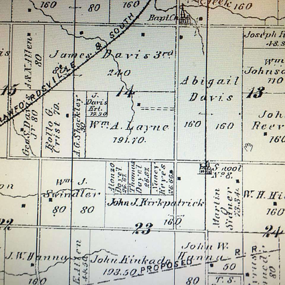
Peterson Country -- Sugar Creek Township, sections 7, 18/19 - the far western side of the county. This area was first settled by Solomon Peterson in 1830. - thanks, Suzie
Peterson Road -- see Tribbett Road
Phillipines (The) -- Weekly Argus New, August 13, 1898 p 5 c 2 -- Lost: Somewhere between Flat Creek school house and The Phillipines 8 ducks. Finer please leave at Grant Cook's and receive reward. (This would be in the Darlington aera)
Pickett's Corner - Ripley Township It was in the news because the Telephone Wires were coming in. The committee for bringing them there: Jeff Etter, John White, Floyd Michael, Daisy Ellis, S. Harwood, Jack Gilkey. I found John Thorn - Sections 2 & 3 & 35, Jeff Etter was in 34 & 35 - Samuel Hardwood was in 36 - but, I'd say it was in NW Corner of 35 - because "Pickett's" actually owned land in that area. - via Suzie B - thanks kid!
Pig Paradise -- okay, this one is NUTS - seriously why would anyone name a town Pig Paradise? But, good old Montgomery County had one in June of 1900 (Weekly Argus June 30th - thanks Jerry T) -- "Charles & Dora Lewis, former Paradise folks, dined with Mr. and Mrs. DS Morris last Sunday. Billy Gray & family drove down to Aaron Nutt's last Sunday and feasted on gooseberry cobbler and ice cream. Saturday, May 20th will occur (hopefully it went off without a hitch since it was more than a month later it was in the above newspaper) the marriage of Winnie Pomphery and Miss Elva Lewis at the home of the bride's parents. Rev. Mater will perform the ceremony. They will go to housekeeping at once in the cabin where Elva was born up on the John Breaks' farm." The young were invited to enjoy the floral swamp with its beautiful spice wood, luxuriant vines, ferns, purple ... the most romantic spot in Montgomery County - a paradise, indeed ... a lover's elysium... drive up the lane, grab a long and lucious kiss, have tender tete-a-tetes and signs and ... Daily News Review AUg 3, 1900 p 4 - Florence & Catherine Boraker are back on the old farm once more. They hav been cutting quite a dash among the town boys, and they had enough ice cream, soda water and buggy rides to last a coon's age. - Walter Boraker, Elmer MIller & Jasper Brown have been building a house for John Cowan, a short distance north of here. They tried to hire me go along and cook for them but I was afraid of the cusses; I didn't go, so they had to batch in the cellar. Brown made the flapjacks; Boraker the coffee and Miller made himself at home. I sent the boys up a Mayapple pudding and a broiled shitpoke and a bottle of wild cheery cider the other day. The trip voted me the queen of goody-makers and Walker went so far as to say I could suspend my garments in his wardrobe any old time. Polly Pacer (correspondent)
Pine Bluff -- the high area above the Deer's Mill bridge. Dates back to early Brown Township.
Pine Breeze --(Source: Crawfordsville Star, September 1885) Possibly in Eastern Wayne Township or Western North Union) Names: Henry Walters, Alice McClelland, Luther Long (via Suz) -- Source: Crawfordsville Star, June 10, 1886 "Pine Breeze " - Sam Davidson has painted his barn red. The corn crop is low for this time of year. Frank Snyder is visiting friends in this vicinity. John Kerr of Cherry Grove has not gained much in health and strength, but is able to be up. Samson Croy of Missouri is visiting his brother Fred Croy and his sister, Julia Lofland. Tom McClamrock, since he has been superintendent, has hauled 108 loads of gravel for repairs. Some time since the residence of Henry Croy caught on fire in the roof but was extinqueshed by Mrs. Croy before much damage was done.
Pine Crossing - this was probably a whistle stop (or the crossing near the whistle stop) on the Vandalia RR and is basically Pine Grove (below)
Pine Grove -- this was a station stop half way between Waveland and Brownsvalley on the south side of the road -- the station and the tracks are long gone but I remember 'em :) (Karen Z) -- Jerry Turner sent me these comments Summer 2012 -- Looking at your list on Gen Web I see you have a Pine Grove listed as a train stop halfway between Browns Valley and Waveland. I wonder if this was where the Midland junction with the Terre Haute & Logansport RR, (Vandalia) was. In 1888 the Midland built 10.5 miles of track from Ladoga to Browns Valley Junction, where it joined with the TH&L RR. In 1890 the Midland built 3.1 miles from Browns Valley to Waveland and eliminated the Browns Valley junction. Waveland Junction 1.1 miles to the west of Waveland (the depot) became the new junction between the railroads. Of course a junction may only have a small junction house and not a larger depot. I know Waveland also had a turntable, water tower, sand house and tool, pump and repair houses for the railroad. did you know that steam engines had sand tanks on the engine and if the engineer wanted better traction he would open the chutes which would pour sand on the tracks in front of the wheels? Curious little factoid. But I wonder if Pine Grove, have not seen any other reference to it, could be the junction that existed only 2 years in Brown Valley. Maybe not since you say it was halfway between. Also from Jerry, my name guru :) I also came across a name for the school number 11 which was located east of Waveland and near where Fairview was. The name I have is Pine Grove or Moore's school as it was also called.
Pine Hills - a walking (nature) area in Shades State Park
Plank Road - same as 100 West (thanks, Suz)
Pleasant Hill- Coal Creek Township - (also known as Wingate) platted by Christian Bever 3-24-1832 Section 15 - remained thus until 1881 when it was changed to Wingate to honor a local man who was active in bringing the Clover Leaf RR to the area and bringing in jobs.
Pleasant Run - Pleasant Run (thanks Jerry T - found in the Weekly News-Review Jan 5, 1901) lists Galloway; Dice; Fletcher; Chambers - Walnut Township area folks. Loved that "quite a large crowd attended the watch meeting at the ME Church Monday night conducted by Rev. Read and James G. Johnson. They stayed till the old years was gone and the new had come. Just as the change was taking place the choir was sining, "God be with you till we meet again!"
(The) Pocket -- near (west) of Balhinch - this is likely an area vs. an actual community but until I find out differently, will leave it as a town :)
Pleasant View -- Source: Indianapolis News 12 July 1902 p 7
(in an article about places to visit in the summer) – Pleasant View (but it has Pleasant Hill, July 12 – The season has fairly opened at Pleasant View and the hotel and campus are teeming with summer visitors and camping parties. Although a comparatively new resort, Pleasant View is becoming one of the most popular in western Indiana. It is situated on Sugar Creek, between the Shades of Death and Turkey Run and is one of the most charming spots along this picturesque stream. Mr. F.A. Stebbins, formerly manager of the Shades of Death has charge of the resort and in addition to a commodious hotel he has about 20 log cabins and cottages for the accommodation of camping parties. 13 of these are now occupied with pleasure seekers. Mr. and Mrs. Clifford Gordon of Danville, Ill are chaperoning a jolly party of young people from Danville and vicinity. The YMCA juniors from Crawfordsville are enjoying their annual outing here and have possession of three log cabins. There are 30 in the party, which is in charge of JB Modesitt the association secretary. They are under rules as stringent as military discipline, but are having a gay time, nevertheless. They will be in camp two weeks. The fishing has been unusually good this season, and some fine hauls have been reported. The banner catch of the year, however was made the first of the week by Judge Jere West, of Crawfordsville, who landed 18 bass with a fly rod one morning before breakfast. His good luck served as an incentive and fishing has since had the call over all other forms of entertainment. A very party from Crawfordsville with Mr. and Mrs. Walter Hoff as chaperone are camped on Spring Cliff Hill. Pleasant View is situated six miles northwest of Waveland and is reached by the Vandalia, the C&SE and the ID&W Railroads.
Polyopolis -- Saturday Evening Journal January 1886 --. Bennet is the only name of who lived there -- all other names were visitors. In 1870 Bennett lived in Coal Creek Township. In 1900 he lived in Linden --- so likely near one of these areas.
Porter's Point. -- Saw a clip in the paper and from the names in the article Porter's Point is located where the Pres. Church is on the 1878 map. The exact location would be at the intersection of US 136 and CR 300 South. Notice one of the owners of the property adjoining the intersection is Mrs. Mary Porter. In 1834 a Pres. Church was formed and a John Porter was an elder. The Union Hill Cemetery is located on the site where the church was originally. The community in this area was known as Union Hill but Porter's Point is the intersection. - thanks to Jerry T for this one :)
Porto Rico - Weekly Argus News 5-6-1899 - states there had been measles there. People mentioned Elza Coons (funeral preached at the ME Church last Friday by Rev. Riley with interment in K of P Cemetery -- this is probably th Mace K of P cemetery so imagine it is in that area as is the one below) - Hale; Elkins they also all felt a shock of an earthquake.
Possum Den -- Weekly Argus News 5-6-1899 -- Lee Chadwick was in Crawfordsville and Julia Wingert was mentioned so also think this is around Mace (probably north and east a bit). Weekly Argus News Feb 11, 1899 -- p 5 - Possum Den is located on the highest point in Montgomery County. Bounded on the north by Crawfordsville on the east by New Ross south by Ladoga and on the west by New Market. It has a population of about 10,000 (not) which consists mostly of the Caucasion race. Is noted for the ugliest men and the prettiest young ladies. If you do not know where to find this on the map you should look where they had the last battle in Santiago and I am sure you will find it.
Possum's Glory -- see Short Horse
Possum Ridge -- along Kerns Creek and marked the southern border of Balhinch . -- in various newspaper articles from 1883-1902
Possum Road - 1075 E (thanks, Suz)
Potato Creek - in Sugar Creek Township, North and West of Bowers, Indiana
Potato Creek Station - in 1878 (Sugar Creek Township) there was a daily mail to the Potato Creek Post Office which was located in the home of Dr. Berryman with pick-up of the mail only twice a week. However, Dr. Berryman was fairly kind to let anyone have their letters if needed. Within a mile or two of this little place in 1878, there were several churches, including two Methodists, one Presbyterian and a German Baptist (Dunkard). It was in Potato Creek Prairie an area that was in the township. The book mentioned in Prairie Edge states that a Post Office was opened here 4-16-1866 and closed 1-15-1900 - the mail for Potato Creek was then made into a Rural Route of Darlington. -- via Dave White (from Reference Department gals) -- James & George White donated the land for the Potato Creek Church in this little burg.- also via Dave -- the families in this area were -- "Hard Core Baptist!"
Potato Hole School - Ripley Township
Poverty's Knoll - see Onion Town
Prairie Edge -- Section 9, Wayne Township -- a post office and a couple of houses existed there from at least 1859 - 1876 -- John Shanklin was the Post Master. This was located just north of where the State Road 55, Interstate 74 Overpass is today. Thanks muches to Jerry Turner for this one and several new place found in our good 'ol Montgomery County :). Suzie with a reference book (Indiana Postal History) from the Crawfordsville District Public Library added to this one -- it had a post office started in 6-7-1855 and closed 1-9-1875 which goes perfectly with Jerry's information.
Preacher's Rock - Franklin Twp - on 32 just west of Shannondale. See Great Boulder
Providence -- In June 1895, Ezba Armstrong married Louise Bowman. The Providence cemetery (Beckville) indicates the area of where this town used to be. Assuming this is the same Providence, it must have been still going in 1927 as the Sept 20th C;'ville Review has a column mentioning several people living in the place (Rev. Eddingfield filled his pulpit Sunday a.m. and eve; Ethel & Lottie Kelsey visited Mrs. Carrie Beebee; Elmore; Witeman; Allen; Richardson; Wilson; Everson; Davis...
Pumpkin Butter X Roads (note X not Cross :) -- Crawfordsville Star 12 Jan 1881 (thanks Jerry T) -- Ike Burson; John Templer; A F Ammerman; Clara Hurd; Ida Seller; Capt. William Huff; Samuel D. Wisehart are all mentioned in the article.
Pumpkin Ridge -- waiting on Jerry Turner, my town guru to find more :) Suzie adds this -- Pumpkin Ridge Crawfordsville Star 28 July 1887 p. 3 -- names there -- Clark May; Aaron Carter is again with Peter Eshelman; Christopher Rhodes is working with his brother Dawson; Eva Martin is the professional sack holder for threshing; Capt. Lawrence has started out on his fall huckstering tour; Fox Johnson, of Etna powder fame, is working for H. Trout; Wall LaFollette and family visited A.E. Elmore's Saturday night. A.S. Amerman was flying around over the ridge last Sunday; Ed Eshelman thinks of locating on the north side of the ridge; Sam Arnold will leave the ridge and go west about the first of August; G.W. Vancleave, the famous churn peddler, is seen in our vicinity quite often; J.W. LaFollette has greatly improved the looks of his residence by the erection of a new yard fence. H. Trout
Quaker Cave - Ripley Township - north of Weir Cemetery - (thanks Suz)
Quakerdom -- near Smartsburg possibly in Section 35 in the eastern part of (North) Union Township - thanks, Suzie B :)
Quakervale -- found in the Crawfordsville Star 11-6-1884 p 3 - where news from various places is listed. Unde Quakervale, the first item listed is: "Everybody voted!!" John Newkirk was in Benton COunty. Pleasant Butler and wife visited Parke County friends...
Quiet Retreat -- (May 26, 1910 newspaper article) -- near Smartsburg (what is now RR 9 Crawfordsville?) - thanks to my great daughter, Suzie Zach B - you rock, kiddo -- some of the names later that year were Emma Sanford; R.W. LaFollette; Thomas Burroughs; Mort Reed; William LaFollette; Petty Stipes; Forbes; Waters; Ed Hamilton; Paul Burroughs; Jim Reed and Thomas Burroughs. ANYONE know for sure where this town is?
Raccoon Corner - Source: Weekly Argus News May 27, 1899 - p 7 - Evidently in the area of Liberty (New Liberty) Church as mention of that in the column twice - there will be memorial services at Liberty Church May 28 3 p.m. Saturday night, May 27th, an ice cream supper will be given at 10 cents per dish for the benefit of the Liberty Church. Other things mentioned - Edgar Marcrum and EMory Lowe went to the Shades Sunday. Emory Lowe and Egar Marcrum are good to go after the doctor. Flora and Frank Mahan visited her parents Sunday.
Raccoon Creek (Big & Little) - Clark Township - flows near Ladoga and New Ross
Rake Pocket - Section #26, Coal Creek Township - there was also a school here by that name (District #2 School #3) - about 1885 - thanks Suzie -- the Montgomery County Remembers said this was called Rape Pocket, but it is much more likely Rake Pocket, because of this story -- Rake Pocket was at the corner of (Now) Highway 25 before reaching 650 North. Basically right as you leave Wayne & enter Coal Creek Township On the east side of the road there was a saw mill and a tavern. On the west side of the road there was a blacksmith shop operated by John Oswalt. His house also had a grocery store & post office. A John Oswalt died @ age 64 in 1916 & he had been a blacksmith along Wingate Road - how cool! It was called Rake Pocket because a "rake" means a dissolute, lewd man. So, when the men gathered here to drink @ the tavern - it became known as the rough guys making it called Rake Pocket. The Montgomery Magazine says the 1864 map shows it - but, I sure don't see anything called "rake" or "rape" pocket. But, the 1864 maps sucks! SBZ - -
Jerry sent me this item - Crawfordsville Weekly Journal 24 June 1869 (so there was a place there about 35 or so years) -- This place was made famous during the war by its ardent devotion to the Democratic party. Never did a neighborhood take a bolder and firmer stand in the hour of peril than did this during the four years of our late "unpleasant mess." In the beginning, it was in favor of the Crittenden Amendment and opposed to every measure to retrain "our Southern brethren" from the full enjoyment of their rights in their own way and when the war was finally inaugurated at Fort Sumpter it was opposed by the Democracy of Rake Pocket in mass meetings at the grocery and on the public highways. I never saw a more united and determined effort by any party or in support of any measure that was put forth here in opposition to the late war. DUring the later years of the war it successively opposed the emancipation proclamation, the enlisting of negroes, the various constitutional amendments and tghe enforcement of the draft. In the Summer of 1863 they refused to be enrolled and would have fought to the bitter end if it had not been for the wiser counsels of the leaders, who presented themselves about this time and persuaded them to submit. During the year the great incubus was removed from our midst. The man that we called, "Bill Poole," but who had an alias, sold out his establishment and removed from among us and that ended the days of a saloon in Rake Pocket. It also ended the dayf os disloyalty and resistance to law, and from that day we have grown and prospered, and now we boast of as good an agricultural neighborhood as Montgomery County affords; and we knew that we are saying a great deal when we say that. Our farms are cultivated, our fen ces repaired, our homes rebuilt, and everything presents a sound and healthy appearance; while before, our neighborhood looked something like a desert waste. Even our farms seem to produce better than when we were polluted with whiskey. The old saw mill tghat was erected in 1852 is yet running and doing a good business. It has furnished lumber enough since its erection to have built a fair sized town and the timber is not half exhausted yet. Our soil is well adapted to wheat, corn and all the samll grains and vegetables, of which we raise an abundant supply. This year we have an unusual amount of wheat out, and it never looked better. Our corn, too is promising, considering the difficulties we had to contend with in planting. In years past we have raised and sent to market a great many hogs which were a fair average with those raised in other parts of the county. Sim Grenard is our great hog Mogul and we all depend on him for all needed information in the pork-producing business. He is also reliable in all business transactions, but his politis are Democratic. Josiah Hutchinson lives about one mile east of this place and is a superb farmer, always raising the best crops of everything and is always sure to get the best prices, too. Jo is the leader of the Democratic party in this township, a position .... that has been weighing on his shoulders for more than twenty years and he bears it with commendable fortitude and to the satisfaction of the "lesser lights." I send this, my first to you, hoping that it may meet with favor in your eyes. If so, you may hear form me again... Dickson
Jerry sent me this item - Crawfordsville Weekly Journal 24 June 1869 (so there was a place there about 35 or so years) -- This place was made famous during the war by its ardent devotion to the Democratic party. Never did a neighborhood take a bolder and firmer stand in the hour of peril than did this during the four years of our late "unpleasant mess." In the beginning, it was in favor of the Crittenden Amendment and opposed to every measure to retrain "our Southern brethren" from the full enjoyment of their rights in their own way and when the war was finally inaugurated at Fort Sumpter it was opposed by the Democracy of Rake Pocket in mass meetings at the grocery and on the public highways. I never saw a more united and determined effort by any party or in support of any measure that was put forth here in opposition to the late war. DUring the later years of the war it successively opposed the emancipation proclamation, the enlisting of negroes, the various constitutional amendments and tghe enforcement of the draft. In the Summer of 1863 they refused to be enrolled and would have fought to the bitter end if it had not been for the wiser counsels of the leaders, who presented themselves about this time and persuaded them to submit. During the year the great incubus was removed from our midst. The man that we called, "Bill Poole," but who had an alias, sold out his establishment and removed from among us and that ended the days of a saloon in Rake Pocket. It also ended the dayf os disloyalty and resistance to law, and from that day we have grown and prospered, and now we boast of as good an agricultural neighborhood as Montgomery County affords; and we knew that we are saying a great deal when we say that. Our farms are cultivated, our fen ces repaired, our homes rebuilt, and everything presents a sound and healthy appearance; while before, our neighborhood looked something like a desert waste. Even our farms seem to produce better than when we were polluted with whiskey. The old saw mill tghat was erected in 1852 is yet running and doing a good business. It has furnished lumber enough since its erection to have built a fair sized town and the timber is not half exhausted yet. Our soil is well adapted to wheat, corn and all the samll grains and vegetables, of which we raise an abundant supply. This year we have an unusual amount of wheat out, and it never looked better. Our corn, too is promising, considering the difficulties we had to contend with in planting. In years past we have raised and sent to market a great many hogs which were a fair average with those raised in other parts of the county. Sim Grenard is our great hog Mogul and we all depend on him for all needed information in the pork-producing business. He is also reliable in all business transactions, but his politis are Democratic. Josiah Hutchinson lives about one mile east of this place and is a superb farmer, always raising the best crops of everything and is always sure to get the best prices, too. Jo is the leader of the Democratic party in this township, a position .... that has been weighing on his shoulders for more than twenty years and he bears it with commendable fortitude and to the satisfaction of the "lesser lights." I send this, my first to you, hoping that it may meet with favor in your eyes. If so, you may hear form me again... Dickson
Rattlesnake -- 21 March 1900 CWJ & also June 1899 CWJ & August 1899 CWJ according to Crawfordsville Library vitals the Rattlesnake vitals range from 1896-1903 - various landowners own property in these sections landowners Sec. 24/26 of S. Union - North of Whitesville
Rattlesnake Creek - crosses Sugar Creek in the southern part of Union Township
Razzoopville -- Although this is likely a joke (about the name, anyway), I thought I'd be safe and include it in our towns because it's pretty funny - yes or no as real :) Source: Crawfordsville Star, May 26, 1887 - Louis Bischof will plat the land bought of William Endean, northwest of the city in town lots as a new addition. He might call it Razzoopville. Thanks Jerry T
Redenbaugh Hill - Scott Twp - on Rd 100 E @ 1 mile south of 600 S
Remley's Bluff - not a town but a physical location -- runs along Rock River Ridge Road - thanks Jerry T (shown on the 1876 Collett's map of Montgomery County)
Reyk Javik - almost wonder if this was a typo in the C'ville Star, Thurs Nov 8, 1883 -- "WC Kimbler broke bread with RJ Virt. Annie Pickering is sewing for Miss Minnie Elmore this week. Preaching at Salem Chapel next Sunday. The Sutton orchestra played at Stewart's Saturday night. James H. Stewart sang at Center Grove Church Tuesday night.
Ridge Farm (mainly school and church) - just west & south side- of 25/32 (Myers Corner). In 1919 the kids quit going to this school & began to go to Alamo.
Ripley -- although I've (kbz) always thought this was just a township, there evidently was a town called that at one point in our history because on the 2nd Saturday in September, December, March and June the Horse Thief Detective Association met here but not sure if this is in Fountain or Montgomery County - most of the listings in the old newspapers were from Montgomery so assuming it is here.
Ripley Township - the Southwestern township - towns of Alamo and Yountsville are in this township. Yountsville was a thriving community up until the 1920s - almost all the people in the area worked at Younts Mill. Sugar Creek goes through part of this hilly area.
Riverside - area where the Indiana Christian Children's Home was that is now a juvenile center - it's the flat section of land on the north side of the road as you enter Ladoga on the west side. Thanks Bill B
Robbers Cove -- in the Crawfordsville Star newspaper on 12 January 1882 under "Pumpkin Butter X Roads" it says, "M.J. Faust & Henry Thompson will soon locate in our villa. As a punster, Jap can not be beaten" (M.J. is Milton Jasper - nicknamed Jap) - MJ and his father lived in Union Township but toward the Mace area but truly I know nothing about where this town is :) - great article - wish they ALL had one this amazing -- Source: Crawfordsville Star, Dec 22, 1881 p 6 Robber’s Cove – Our village or villa lies just north of Mace. William Active Everson is mayor or superintendent of the Cover. Wm. W. Ward is one of our most enterprising farmers; raises good crops and keeps on hand a fine lot of blooded stock. He is the owner of two fine farms of 8 acres each, good dwellings and good barns and all necessary outbuildings, splendid fences and all of his ground is in a high state of cultivation, so that when he sows he is sure to reap. What a pity more of our farmers are not more systematic and less slovenly. Mr. Ward at present is quite sick with typhoid fever, but that never failing physician on this fever, Dr. Jere Eddingfield, is bringing him through all o.k. Wm. Ward served through the late war with distinction and credit to his country, his family and himself. William Henry Harrison Thompson, a soldier by profession, is now living on the other farm of Mr. Ward and is an elegant farmer, but is going to leave the Cove in the near future and locate in Suttonsburg. Mr. Thompson won unfading laurels in the late unpleasantness is also a pleasant and fluent talker; will tell very interesting stories of hair-breadth escapes which he made while acting as a federal scout. Jasper Weaver is next on the list; is not very old, has six boys, is a wonderful hog raiser, and is a good citizen. Next is J.W. Ward, the famous coon hunter of the Cove, is a good farmer and owns a steam thresher and clover huller. People far and near would rather have John thrash for them than any other man since Bob Finch quite the business, who also lives in the suburbs of the Cover. W.W. Johnson is a live wide-awake citizen, ever ready for any improvement that will be advantageous to himself or his neighbors. But of all the whole-souled boys living there is corporal Jasper Milton Faust, who served all through the Army of the Potomac with W.S. Hancock and Gen. Love. A man in talking with Corporal Faust of the scenes through which he passed during the seven days’ battle of the Wilderness will forget that he is hungry if in that condition. J.S. Williams is another splendid fellow and is an excellent farmer. He lives on the farm of Wm. Johnston. Geo. W. Lynn is one of leading farmers.
Robert's Chapel - see church listing
Rock River Ridge Road -- from Jerry T -- This is the road you take off of the Country Club road to get to the Sugar Creek Trail bridge. Sugar Creek used to be called Rock River. The road originally followed Sugar Creek and came up behind where the Country club is located located now. Notice the small stream is named Millers Run. Troutman's mill was located just west of where the road turns today, Gunkle's mill around where the 3 is. Just west of where the road crosses Millers run you can still see some iron rails going across the road and they may have been some sort of track to move the flour or grain to and from the railroad stop at Troutman's station. See MAP
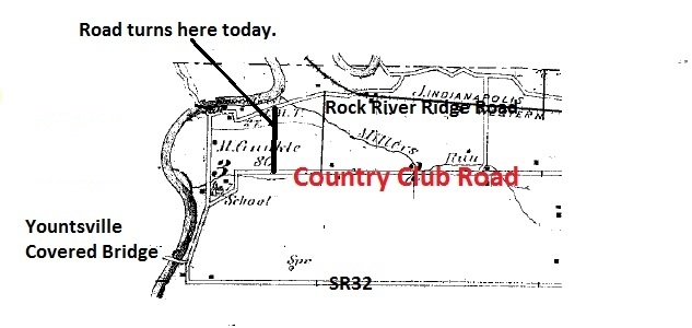
Rock Road - Brown Township - December 1910 newspaper personals - my fab daughter, Suzie went on to find more on this town/place. From all descriptions, names, close towns mentioned, this seems to be the lost town where you turn from 47 onto the Old Waveland Road only don't turn - go up the small hill and this town would be there. Fairly decidedly gone by 1917. Taylors and Grahams lived in the area in 1910.
Rocky Ridge - a development near the town of Darlington, Indiana
Rocky Run -- Source: Colton’s Maps of Indiana: Geography, Statistics, Institutions, County Topography. Richard S. Fisher. NY: JH Colton, 1852.
Roll's Run - NE of Wingate, SW of New Richmond (thanks Suzie (New Richmond Newspaper book, 1903-1904) --
Source: New Richmond Record 11 April 1901 p 2
“Roll’s Run” news – Aunt Polly Roll is still alive and in good health. Other mentioned in the piece were Hormell; Meharry; Bottenberg. Imagine this was where the Rolls lived.
Ronkville - 1894 time, NE corner of Clark Sec 1,12 & 13 area - names are: Call, Gray, Micheltree. Mt. Pleasant is also mentioned often. Plus, Tipton, Rettinger & Ronk -- Suzie sent this hilarious piece from the - 14 Sept 1894 CWJ -- "Some folks are getting quite clever of late. Last Sunday they took two pies from Lomie Rettinger's pie cupboard and laid ten pennies on another pie for pay." Cracked me up! (Lomie died in 1914 - so, at least the pie thief didn't give her a heart attack - ha ha)
Rosebower Spring -- This appears to be in Southern So. Union - Sec 27/34 area (just West of Whitesville). This is where the J. Oliver School is - & J. Oliver is even mentioned as cutting corn. CWJ 1894 - Sept 14. Davidson & Gunkle. The J. Oliver School (1898) was also called School #24 & the McMullen School (1878). This would be around 500S/200E in S. Union. (via Suzie -9-4-2014)
ROME –
Source: Crawfordsville Weekly Journal 30 August 1895 p 6
People in the news for Rome were: Fannie Stewart who was poorly; Cora Hopper was the guest of Maude Livengood. Virgil Edwards spent Sunday with his brother at this place. Some of Miss Helen Mount’s lady friends have been visiting her the past week. Some of us hard working men have been hauling gravel on the WJ Mullen road. Mrs Maude and Lulu Livengood and Cora Hopper spent Tuesday in Darlington. Vincent Craig of Darlington is having a tubular well driven on his farm occupied by Sherman Hall. M/M JH Stewart and family attended Friends’ quarterly meeting at Sugar Plain. The young folks of his neighborhood will give a musical and elocutionary entertainment at Old Salem Church the evening of Aug 31, free to all. Admission 50 cents. (sic – that’s what it says) and Silas Pickering was cutting wood for WC Miller.
Ross - could never figure why New Ross was called that but this could explain it -- Ross was about 1/2 mile east of present day New Ross
Round Corner - kbz - Source: Waynetown Hornet newspaper 28 Jan 1888 p 4
Mentioned under this town’s news heading are Walter Mill (timber business); Ingersolls (meeting); Ora Pickett (mustache); James Hendricks (home for a visit); Wm. Straub (hunting). Sherry Legg Young I think has pegged where this is – “ In my 1897 plat book, in the corner where Wayne and Ripley meet at the Fountain County line, there are Hendricks, Pickett’s and Ingersoll’s. They aren’t next door to one another, but they’re in the same area. There is a weird > shaped corner in that area it looks like.” Sounds like a very logical finding pattern to me! Sections 3 & 35 is where these family live and the curve of the road. This would be 32 just west of 25. We’ll go with this unless we hear differently and DO let me know if it is incorrect but pretty sure Sherry has it right – you rock, girl!!! !!!!
Round Hill -- Coal Creek Township - a small hamlet in the 1878 Atlas -- this from Jerry T: Thanks muches JT -- Round hill was a hamlet located northwest of Crawfordsville on the border of section 25 and 26 in Coal Creek Township and approximately a mile west of Cherry Grove. More specifically round Hill was located at the intersection of New Richmond road and 750 North. The Hamlets name originated from the round hill where a Methodist church and the Round Hill school (Number 6) were located. At one time a man by the name of Jeff Bennett ran a blacksmith shop just south of the church and a post office was located at the intersection of the roads. Mail was delivered twice a week in the late 1800’s. The Methodist Church closed in 1920 and the old bell was taken to the United Methodist Church in New Richmond. The one room school closed in 1911 and the students were sent to the New Richmond school. One memorable inhabitant of Round Hill was Ralph Lee Wilson, the famous Wabash football player who uttered the words, ”Did Wabash win?” His boyhood days were spent here growing up in Round Hill..
Rurral (sic) Route No. 2 -- Jerry Turner found this in the Weekly Argus News 10-14-1899 -- gives names of Oliver; Lester; Auman, Everson, Mills.
Salem - at first I thought this might be New Salem but it is not, in Montgomery then perhaps Salem Chapel (it is not - other end of our county. So, this we have #492 - unbelievable - here are items from where I found the nanme - Source: Crawfordsville Review 25 Feb 1899 p 8 “Salem” news items – Charles Davis and wife entertained Monday night. Wm. Walters spent Sunday with his wife. Anna Gill is visiting Roachdale and Ladoga friends. Arthur Day and James Taylor were the only persons to raise the alarm of fire. The editor of the Herald and L. Lumpkins sojourned in the city Monday. Mrs. Banta, of Martinsville, is visiting her father and mother, Mr. and Mrs. J. Emmons. Ed Anderson is billed here for March 2, 3, and 4. He comes highly recommended and everyone should come out and give him a good house. The opera house is a public benefit and should be patronized by every public-spirited citizen. We suffered the loss of our saw mill on Monday night at 12 o’clock by fire. The cause of the conflagration is unknown but the citizens realize the fact that it will make times dull for our laborers and merchants. Loss was about $1200. No insurance.
Salem Chapel -- this has to be very close to the Tippecanoe line according to what was reported and the people in the town in Feb 1885 (C'ville Star) -- Al Bunday and Miss Ella Bunday were married last week. We are sorry to hear of the death of Richard Hart who went to Arkansas last fall. The bereaved family have the sympathies of the community. Ed Mount and wife of Orth Sunday were here. Ollie Beck has moved to North Salem.
Santiago -- evidently or near Linnsburg (Mace area) - Source: Weekly Argus news Feb 4, 1899 p 3 -- Our shippers, Edward & Linn ships cattle almost every day. Arch Martin of Linnsburgh (sic) sold to Edwards & Linn one oxen weighing 1,800 pounds. Mr. Martin also has two fine jersey calves, that weighed 3,500 pounds. He says they are the largest in Indiana. If anyone can beat this, please report! Charles Lockridge and kate ENgle are the only one that are going to try the final examination in Febuary from No. 2.
Scatterville -- was in the CWJ in 1893 but, the 3 names I found I can't seem to "DEFINITELY" place their land - they fall between the 2 plat maps I have handy. Ironically the paper did say Cabbage Hugelheim bought John Delaney's land - that name shouldn't be hard to locate - but, he isn't in our cemeteries or vitals. There was also a J.S. Williams & Harry Ward (But, there is a J. Williams in Walnut & several Wards in Walnut) - from Suzie Z B
Scott Township - lower central township; the town of New Market lies partially in this township. Parkersburg, once a fairly thriving burg is slowly dwindling away, sad to say. It at one time had one of the best springs for miles around but was eventually contaminated and closed. The town was laid out (by Jacob and Christopher Shuck) in 1829 so is one of the older towns in the county. The soil is very fertile in this township and even today, 2013, has much farming occuring. Cornstalk, Big Raccoon Creek, Rattlesnake and Indian Creek all flow through the township. William Frame; James Foster; Daniel Arnolds; Graybills; Watkins; Shucks; Gott; Lafollette; Ashby; Byrd and Millers were early settlers.
Scottland Yard - said to be named for a man named Scott who built one of the first houses there -- this is the NW side of Ladoga
Schrader Road -- goes near Pawnee and Lapland
Sellers Corner - ALthough I saw no Sellers in Sellers Corner, the names found in the Weekly Argus New May 8, 1897 p 5 that live there were ZJ Walker (who took his rat terrier dog to the show at Darlington and won first prize); John Crawford is recovering from the grippe; Dr. Eddingfield and TA Armstrong are the agents here for a darning needle firm in Chicago. John Fletcher and Goerge Lynn are improving their farms by putting up wire fence.
Shades State Park - located on State Highway 234 south and west of Crawfordsville -- see the Waveland photo album
Shady Nook -- the death of Robert Weeks was found under a "Shady Nook section" with other towns and areas - November 1895 in the Crawfordsville Weekly Journal 15 Nov 1895 p 8
Shannondale- Border with Boone County -- in Franklin Twp, Sec 36 platted 5-10-1851 by Isaac Lane and George Woods - read an old Shannondale history (sort of)
Shiloh -- There is a Shiloh cemetery where a church likely was not far outside of Crawfordsville (left side) on way to Mace. Jerry Turner has been so instrumental in finding information on these sites -- here is his research on Shiloh - thanks muches Jerry -- In the June 1979 issue of Montgomery Magazine is an ad on the back about a house, Shiloh Hill. It appears by reading this that Shiloh was located at the corner of Nucor Road and US 136. The Shiloh cemetery is on top of the hill there. According to the ad, Christopher Dice came from Virginia and built a cabin on the property.He built a second home which resembles the Virginia tidewater houses. As this house (1860-1865) was being built his young daughter’s clothing caught fire from the fireplace and burned the cabin down. She was killed in the accident. According to bios this would have had to been either Sarah F. or Anna B. Dice. The house is on top of the hill and the community consisted of a church (moved to Crawfordsville and became the Fremont Baptist Church), a few homes, a graveyard (Shiloh graveyard) and a grainery. I do have some newspaper clippings from Shiloh in the late 1800's and will cross reference the names with landowners when I can to verify but this does appear to be the location. Another fact about the place is that the little valley that US 136 goes through here is called Chigger Hollow.
Shirley Hill -- see Manchester
Short Horse -- Source: Crawfordsvillle Review 12 Jan 1895 - "Montgomery County news: -- Short Horse is boomin'. The infant child of Thomas Wendle, is very sick with croup. So fur (sic) we've sekured twenty-five new subscriptions for the good old Review. Grandpa Dunn wa 82 on Thursday and his wife gave him a dinner party surprise at which the old man was much tickeled. Other people mentioned: Abe Chester; Fred Coffern - what happened between myself and the low-life snipe of a correspondence, Harry Rhodes of Possum's Glory is our own affairs !
Shucktown - see Somerset
Six Mile Prairie -- in Madison Township -- the town of Linden is on the SE corner of a 6-mile prairie - it is assumed there was a town of that name, as well but with further research we may have to nix this as a town - :) Anyone know let me know - kbz
Slab Town - in the 300 South era near Barcus Orchard
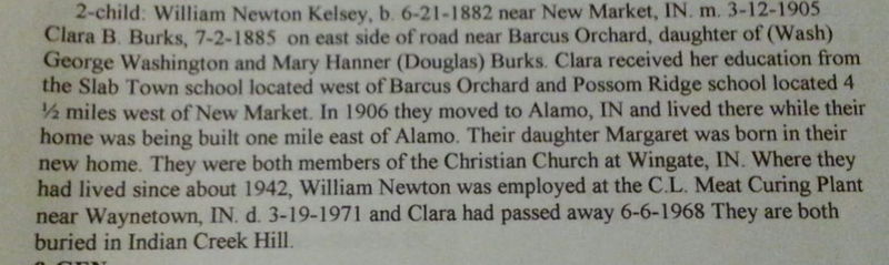
Sleepy Hollow - SW of New Richmond (Source: New Richmond newspaper book 1903-1904 - thanks Suz)
Slickville -- this is either another name for Mace or the upper section of it - June 1895 (Weekly Argus News) news items discuss Patsy Edward has a new bicycle suit; Ice cream supper at shilow; Ode Wellever has already killed 56 squirrels; Ice ceam supper at Mace the third Saturday night of this month. Joe Abbotts hogs are dying with cholera. The Mace Bicycle club is going to take a trip to Linnsburg Sunday .
Smalley Ford -- Raccoon Creek in Scott Twp, 110' bridge, built by Indianapolis Bridge Company for $1,475 (bid accepted on May 7, 1902 by county commissioners) - thanks Jerry T.
Smartsburg - Smartsburg is a little village on SR 32 and 400 East. This village was named for Dr. James Smart of Darlington. In the 1800’s the village had a store, blacksmith (William Foster), a grist mill, a church and a school. The grist mill, located on Little Sugar Creek, was one of the earliest mills in the county and operated under Marcus Mote and then James Warren into the late 1800’s. The Church was formed in 1887 and met in the old schoolhouse until a church was built in 1894. This church has undergone several renovations and additions but it still in use. Thanks to Jerry T :)
Smith Crossing - South Union Township (Suz - that's kind of broad - have a better description?)
Smithville -- - January 1875 "WE have 44 voters in school district No. 2 & 202 men, women & children 40 dewlling house 1 school house 2 churches (Newlight & United Brethren) 1 saw mill 1 blacksmith shop 1 chair shop 1 spring wagon peddler 1 horse trader. -- Hattie Avery is no better. Old Mother Armstrong is sick. Joseph Wheeler & Jane Roads got married. Eph. Livengood is going to Fountain county to sell pruning shears. The farmers here say they are a good thing. (thanks Suzie)
SMOKY HILLS - Source: Crawfordsville Weekly Journal 28 Jan 1888 p 8
In the Weekly Journal today there is an article by that name.. McCall, Stockton, Elston, and seems to be around the Linden area
Smokey Row - definitely not same as the one below -- - may be same as McKinley Hill but don't think so - anyone ever find out, let me know -- we discovered 3 towns in this article -- Source: Crawfordsville Review 17 February 1894 -- News items under the title, "Smokey Row" - Union Township - names included in the news article - Clossin; McCormick; McKinley; Monroe; Newland - at the bottom of the little items there was this -- Smokey Row is bounded on the north by Mt. Tabor the east by McKinley - west by Otterbein (first thought this was Otterbein in Tippecanoe County but it can not be but might be why this town must not have existed long) and south by Whitesville. Since Mt. Tabor was at 150 South and 200 East in today's world and Whitesville 500 S and 400 E it likely was it was evidently in about the 200-400 range South and ? on the East - pretty exciting
Smoky Row -- name given to the area along South Street in Ladoga - the smoke came from the tannery and blew across the area -- thanks Bill Boone
Snyder's Mill -- 1888 - near Waynetown (possibly even into Fountain but as of now, we'll count it with this group) -- George and James Snyder and an Ellis family mentioned (Waynetown Hornet newspaper, March 17, 1888)
Soap Factory - gossip column in the 1890 newspapers - thanks to Suzie B -- US 74 area
Soap Factory Road -- parallel along 74 near Brick Yard Road
Social Corner - area of New Ross where in May 1897 (Weekly Argus New 8 May 1897 p 5) George Layne had the measles; Esba Armstrong was doing husckering; Tom and WH Brown bought a new surrey
Sodom (for real) -- Madison Township, Section 16 or Section 21 - about 1890 - thanks Suz -- and Jerry sent a nifty little piece showing this one - Crawfordsville Star, April 9, 1885 - talks about Doc Shotts; F. Proctor; Mike Mahoney; Sam Paddack; Ed Bush and Wm. Ivens plus others - thanks you two :)
Somerset - about 1829 then renamed Shucktown (was near the Parkersburg stream) - thanks to dear daughter, Suzie for this one :) Jerry adds much more - I love these two kids :) All three of these names were the same place. This happened quite frequently in history. The origins of Parkersburg began in 1829 when Jacob and Christopher Shuck laid out a village by the name of Somerset near the springs. However many people called it Shucktown in honor of of its original founders. In 1834 Nathaniel Parker relocated from Swanksville, in Putnam County to Somerset. Parker was the last inhabitant of Swanksville and the postmaster. After residing in Somerset for a time he decided to open a Post Office in Somerset using the Swanksville Post office material. This was the first post office in Scott Township and Mr. Parker was the Postmaster until he retired around 1850 and Robert Ramsey took over the duties. The men who platted the town of Parkersburg in 1837 named it in honor of the postmaster. There was some animosity among the residents about the name. Thomas Faith eventually petitioned to have the name changed to Faithville and succeeded. But it was short lived and two years later the name reverted back to Parkersburg. In the beginning the towns name was spelled Parkersburgh but in 1893 the h was dropped off. Sp the town around the springs was known under four different names; Somerset, Shucktown, Parkersburgh and Faithville and eventually became Parkersburg as we know it today.
Sommer Ditch -
South Union - indicates the bottom part of Union Township - see note on North Union
Spencer Creek -
Sperry Valley -- The mill was across the road from where the UPS building is currently located. The road that goes to the Elston softball fields basically goes past where the mill was. The concrete bridge was built just west of the old covered bridge so the road was a little further east. As you can see in this picture the mill is on the right side. There were several building there including a saw mill. Sperry Valley may have been that whole area where the electric company Frodges and the car lot is now. JT - thanks to Jerry also for this map showing where Sperry Valley is/was
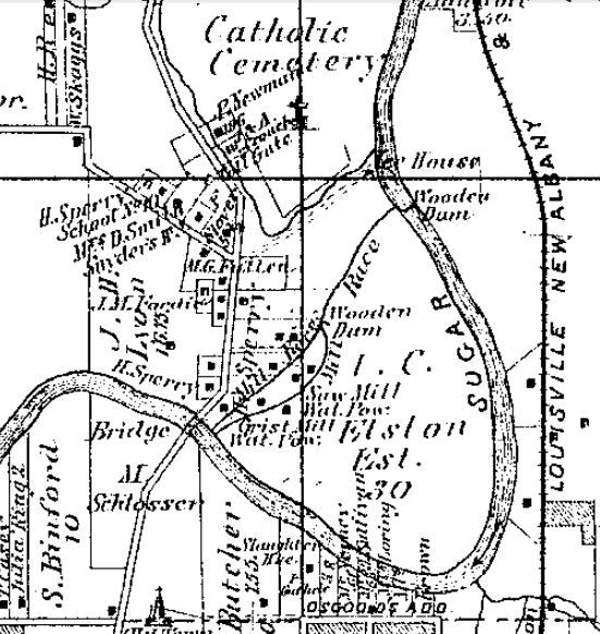
Sperryville -- this is obviously on Lafayette Avenue near where the mill was - sad but interesting happening in 1891 -- thanks to Jerry Turner for sending this one -- Source: Weekly Argus News May 9, 1891 Wednesday afternoon as Jessie Hoxie, a little girl about 11 years old, whose parents live at 110 Spring Street was passing through the old town cemetery on her way to Sperryville where her parents formerly resided she was assaulted by an unknown negro boy about 14 years of agte, whose makeup is composed of more devil than human. After seizing her he made an attempt to outrage her person, but the determined resistance and cries of the girl frightened the black fiend away before he accomplished his purpose. The poor girl returned to her home crying, almost exhausted, severaly bruised, her clothing soiled, and between her sobs related what had happened. Search was immediately made for the young rascal who had evidently became frightened and concealed himself. But up to this time he has not been found.
Spring Branch -
Spring Valley --
Steam Mills -- Source: Atlas of Montgomery COunty. Chicago: Beers, 1878 p 54 - Sullivan, William H. PO Crawfordsville; Steam Mills; native of Campbell County, Kentucky; settled in this county in 1877.
Still House -- 9 March 1875 Crawfordsville Star p 3 col :3 -- "Still House" is situated one mile west of New Ross on a little branch called "Corn Stalk." This stream has been on a regular old "high" but is once more passable. Mentions Josh Corn Will, Morris and James Stewart Wm. H. Stewart J.A. Stewart Geo. W. Duke
Stockwell Road -- north out of Darlington leading to the small town of Stockwell
Stone Spine -- The Cut -- Brown Township (thanks to Suz)
Stoneburg -- from Suzie - August 1896 an Everett Grissom s/o Tom died. He had been born 13 July 1896 :( Tuberculosis John Busenbark. Union Township and from these names and time frame, it is likely North and East of Whitesville.
Stoner Settlement -- IN the 3rd of July 1896 Weekly Journal, Jesse Routh, Sr. died and was "raised in the "Stoner Settlement" eas of Ladoga. - thanks so much to Kim H
Stony Point -- from Suzie -- Another one - I'd say Ripley/Wayne area - but, haven't pinpointed it down much. Since you know some of the names (lots better than me - but, I'm starting to place them) --- you might just know ... Barnett Willinson (williamson?) Dan Stonebraker Joseph Stonebraker Wm. "" Lemuel Ocheltree - Wingate maybe -- "Isaac Wright - shook the dust from his feet of Balhinch & now lives in these parts" :) -- this from Jerry Turner - good thought but the cemetery pic on findagrave doesn't give much of a hill look - may have to drive out that way and see :) Stonebraker cemetery is north of Thunder valley in ripley twnship. Could be close to there. - in another e-mail Jerry notes and I agree (HOPE we're right) --" From the 1864 atlas I see Stonebrakers and a Wright owning property around Thunder Valley. The only Ocheltree I saw listed was in Coal Creek Township just south of Wingate. No Stonebrakers there. Since Stony Point mentions so many Stonebrakers I bet the point was around Thunder Valley." -- SO here's the story straight from the newspaper -- Source: Crawfordsville Weekly Journal 18 Sept 1873 -- Perhaps some of the readers of the Journal would like to know where our town is situated and why it is called Stony Point. Our rural city is situated two miles west of Darlington o the north side of the beautiful and rolling stream of Rock River. We are about 3 miles south of the terminus of the great Lye Creek canal which runs through drains and thereby brings into use some of the richest parts of our county. As for good water, timber, soil and stone, we think we are second to none of the cities in the West. As to our name I wish to say that we are indebted to the early historians who inform us that the name Stony Point was given us by the early pioneers who used to come to the stone quarry near the head of navigation on Lye Creek to get stone of which to build their chimneys, many of which are as good as when built, the quarry is owned by Wm. Lee who keeps ready quarried any amont of genuine the proof stone, they are far superior to brick where intense heat is required.
Stop Corner -- In the Crawfordsville Weekly Journal, 4 Jan 1895, page 8 – there are bleeps from several towns. Stop Corner is one of them. It surely is near Ladoga somewhere as Hostetters (Lafe starting to Missouri; NJ sold his trotter Kate for $300; John and wife visited his brother near Parkersburg and Simon had an amazing Jersey milk cow); Mote (Clyde passed through to catch “the little wren.” And Nichols (John accompanied Mintie Hunt to the meeting at Ladoga).
Stout Ford -- located in Union Township -- an 80' iron bridge was built (bid accepted May 7, 1901 by the county commissioners) by the Canton Bridge Company for $1,738 for this and the Dice Ford bridge nearby - thanks muches to Jerry T for this one - not sure if it is a "real ford" (probably is since it is dicussing bridges) or a town or an area -- Anyone know?
Stover's Mill -- North Union near Sugar Creek (1850s-60s) -- found by Jerry Turner in an 1852 Montgomery County map – possibly could be just a mill but there is a dot like the other towns so until we find differently will add to the town list (lower western part of south Union township) – about two miles north of Crawfordsville
Stringtown -- it has land owners in NWest Union Twp - sections 2/3 & 6/7 that I found near Wesley (thanks Suzie B) -- Jerry also sent an article from the Weekly Argus News Oct 14, 1899 and it is titled String Town in that newspaper. Utterback; Walter; Gerard; Johns and Croy are names in the piece.
Stumptown -- county line road just west of the railroad outside of Roachdale (thanks Bill Boone)
Sugar Camp -- -- at White School - by 700 South in Scott Township - -- (thanks to Suzie)
Sugar Creek - flows through much of Montgomery County; biggest creek in the county.
Sugar Creek Township -- in northern Montgomery County. Horrendous floods occurred New Years Day 1847 and August 1875. Potato Creek; Lye Creek and Bowers Branch drain into the main water of the county, Sugar Creek. Martin Bowers, Solomon Peterson along with Kious, Waugh, Horney were all early settlers. Wild hogs and other game ran wild in the early day.
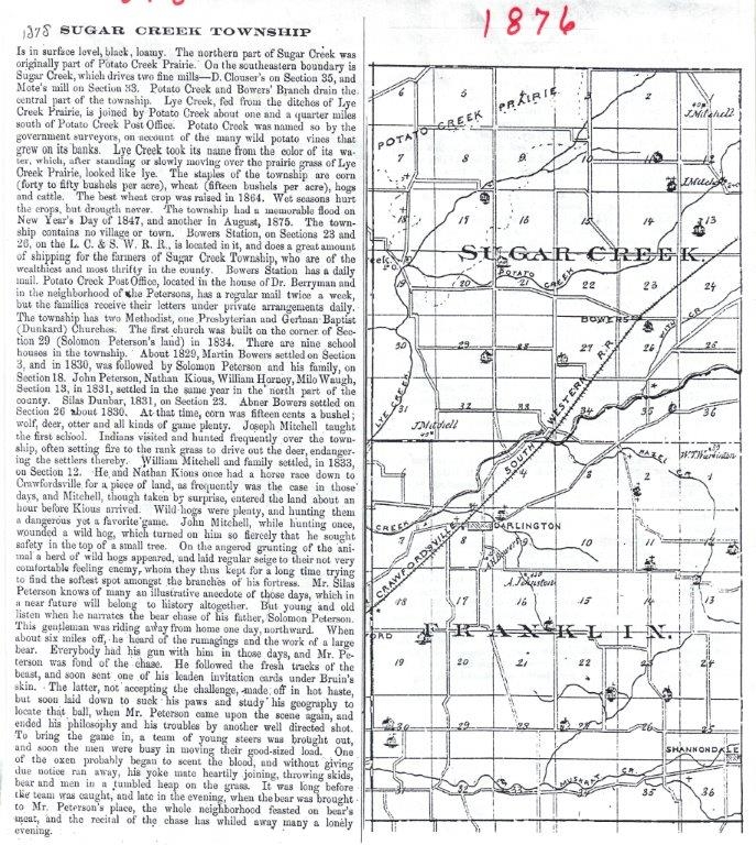
Sugar Grove -- near New Richmond area (1918 -- Clara Crowder Taylor dies - her brother of the Sugar Grove vicinity.
Sugar Ridge -- 6 Feb 1875 Crawfordsville Weekly Review - Sugar Ridge is 3 miles north of Darlington Some snow. Health generally good. Having a lively time here. There was a social dance at Ches. Tremble's last Tuesday night for which the ladies did the calling. Abraham Null is making rails for the Peterson brothers. Abe is a good hand at the business. The writing school at this place is played out. The teacher at the Boots school house, Mr. Conrad, is having some trouble. He has expelled one scholar and has the impudence to call his pupils monkeys and imps, and tells them that they will steal anything that is loose. We think Mr. Conrad is out of order. We have a very large school here, about sixty names enrolled. Miss Jennie Perkins is teacher. Rev. Henry Loring of the M.E. church will preach at this place next Sunday at 11 o'clock a.m. Thanks, thanks, thanks, Suzie - this made 270 towns :)
Sugar River -- a post office and small community west of Garfield (that did have a school) around the mid 1870s. Again found by my town guru, Jerry Turner - thanks Jer! Sugar Creek was also named Sugar River very early in Montgomery County's day
Sulphur Spring -- Source: Crawfordsville Weekly Journal 12-3-1897 - Mrs. Vine Snyders was the guest of Mrs. Etta Ford Friday - other names mentioned are Booker; Peterson; Still;- thanks Jerry T --Sugar Creek Township near Cottage Grove School house (see Alumni for map)
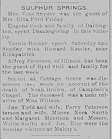
Sunflower -- thanks Suzie ZB :) 1894 era - Sections 9-11 - NE Northern Union Township - David Jackson owned 101 acres; SD Kellison 80 acres. Edward Conrad and wife are setting up housekeeping on the old Swisher farm.
Sutton's Ford -- C'ville Star 10-25-1883 -- Kid Sutton walks behind a flourishing mustache. M.J. Faust is teaming on the Finch Gravel Road. Elmore Lafollette sports the finest team in the village. W.G. Hutchings of Arkansas is visiting relatives. James Billingsly of Indianapolis is visiting at Mrs. Shavers. R.C. Craig has returned from Missouri, looking well and hearty. Sim McDowell has been blasting rocks since the Ohio election. Squire Martin's new house has been served with a coat of paint. Bob Craig and family have returned from a visit to Boone Co. D.E. Elmore visitied his honorable friend, J.W. Shaver last week. Harding Caster is hauling the foundation timber for his new house. The young people will organize a historical society at the school house. Nasby Sutton and Israel Creque have serious attractions at Smartsburg. It is reported that Ed Eshelman will open a butcher shop at Kimler corner. Dr. W. Dickson is running a delivery wagon for Ed Eshelman's beef shop. C.H. Elmore and H.H. Craig visited Capt. Huff of Shannondale, last Sunday. Albert Dickson and his brother Oliver are engaged in the horse trading business. The Finch brothers are running a saw ... with their tile factory. This is likely near Shannondale.
Swamp College -- see Penobscott
Swampy Plains -- thanks to Jerry Turner for this one -- (1887 C'ville Star) he thinks this is the swamps south and southeast of the Linnsburg area. Names mentioned in the news article were Mount; Peck; Coulter; and Hunt all names of that area. "Vest Coleman is now working for G.W. Smith. Clinfton Linn is working for Beecher Dice this spring -April 28, C'ville Star 1887
Swans Down -- Weekly Argus News Jan 6, 1900 - gives Frank Mills cutting corn stalks and Ed Simms visiting them. Born to Jacob Simms and wife a boy on Dec 26th. Albert Vails took dinner with Jacob Simms on New Years. Mrs. Ella McClamroch on sick list - James Hunter is talking of moving on his father-in-law's place; Mr. Spencer will move into the house vacated by Hunter; Frank Mahan will move in the house vacated by Spencer. Goodness.
Sycamore Ford -- is JUST Northeast of Deers Mill and south of Alamo - a now extinct area except that Sycamore Girl Scout Camp is located here (State Highway 234 - north of the Shades State Park)
Sycamore Park -- probably same as Sycamore Ford -- 1908 - Mrs. Anna Smith wife of Elias resideing near Sycamore Park south of Alamo died Sunday night and was buried at Indian Creek Cemetery. The funeral was conducted at the residence Tuesday morning at 10. (Crawfordsville Weekly Journal Aug 14, 1908 p 6)
Tadmore -- Sure would like to know a tad-more about this little place :)
Tallyho -- in northwestern Walnut Township -- in 1900 (March and others) newspapers - items mention names of Loop, Crain, Hiatt, Evans and Dice.
Tattler's Corner -- Section 19 - 30 -- in sections 19 & 30 of Coal Creek Township. W.W. Tiffany -- also a Bennett mentioned - there is a Bennett in section 19 also. This is NW of Boston Store & SW of New Richmond - thanks Suzie - #273 - I think she's workin' on 275 at least -- heehee
Taylor Corner - S. R. 32; at Co. Rd 600 W
Texas -- we at first felt this was where Texas School is, but with more thought - perhaps not - read what Suzie has to say - if we eventually find it is indeed the exact same place, we'll merge these two :) -- It looks like "TEXAS" must be near the "Texas School" in Ripley area - but, in the Dec 1897 CDJ Texas is a town in the gossip column. Lots of Etters were mentioned. There were some Davis, Harwood, White, Huffmire, Johnson's & Michaels too.
Texas School - Ripley Township near Camp Talitha -- (thanks to Suzie) -- Source: Crawfordsville Journal August 9, 1917 – Texas School House – Mrs. Howard Farley and babe of Park Grove and Mrs. John Farley of Mace spent Friday with the latter’s daughter, Mrs. Guy Demoret and children. (thanks to Chris W) -- The origial was on the south side of 234 across from the Texas Cemetary. (Jerry Turner) – there were also other locations for Texas in Ripley, as well. In 1868 it was west of Alamo but in 1891 James Allen deeded land for a new Texas school that closed down in 1916.
The Cut -- Brown Township
Thompson's Bluff -- again, thanks JT -- C'ville Star Dec 9, 1886 lists rumors saying Henry Austin is the only person that goes out in their woods after night in his buggy to hunt cows... also mentions Miss Harris supervising their school; child of Wesley Hughes not expected to live; and a short complaint saying the paper wasn't surprised about the county school superintendent Mr. Overton. Not sure where this is as no real place is mentioned A.T. Kellison lead a Temperance meeting at the ME Church. Guessing on this one but think it's in Union Township just north and west of C'ville.
Thorntown Road -- what is now State Road 47 between Darlington and Thorntown -- in early days this stretch of road was also known as the Old Indian Trail and Clouser Road
Three -- land owners (Stub Dice - what a name) in Walnut Twp - thanks to Suzie
Thunder Valley - (thanks, thanks, thanks to Jerry T, one of my town pals) -- in Ripley Township. Located west of road 600W and south of 400S, a small creek, Stonebreaker Branch, flows by the Stonebreaker Cemetery on 400S and into Thunder Valley, eventually flowing into Sugar Creek a half mile west of the Jim Davis Bridge. Legend has the Native Americans calling it a valley of thunder and the early pioneers translated it into Thunder Valley.
Tiger's Valley -- in at least the 1880s. Brattons; Flora; Sanfords; Robbins; Wilson and Warrens are some of the names in this area - east of Crawfordsville, "generally known that we have a broom factory situated one mile east of Crawfordsville and Tiger's Valley produces most of the bursh manufactured there and is the old home of the proprietor, G. Truitt Wilson whose brooms are noted for their endurance and good sweeping qualities," Crawfordsville Jo\ournal 7-28-1887. Thanks, Suzie B
Tile Siding - Big 4 RR stop - next to Halfway Road - 400 West - North of Thompson Cemetery in Wayne Township - (thanks to Suzie) -- this just in (1-26-2013) from Jerry T -- Tile siding was actually only a second set of rails so the railroad could place boxcars and flatcars they did not need. Manchester, north of 74, was the same kind of siding for the Monon RR. They called these places sidings or switches where they could switch cars. See map Jerry sent from the 1878 atlas -- see map . Source: Crawfordsville Star, Aug 4, 1887. Blaze broke out south side of IB&W Railroad 1/2 mile east of Tile SIding (spread over 40-acre of stubble field on the Bailey farm - only real damage burned 80 rods of rail fence - desperate fighting to check the spreading flames)
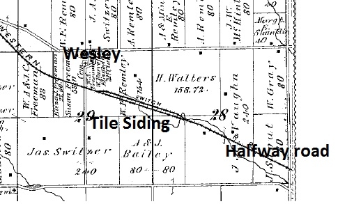
Tilneyville (thanks to Jerry T) -- Source: Crawfordsville Journal 3 May 1895 – mentions Andy Young & John Goben – near “Big 4 Arch Bridge” at Sugar Creek
Tinkersville -- see Tinkertown below
Tinkertown -- from Jerry T -- - intersection of Ladoga road and CR 300 south. (click on description to see where this was/is). Shady Nook School about ¼ mile east at corner of 200 east and 300 south. Named because a man who lived there was a handy man. At one time a blacksmith and wood shop run by two brothers was located there along with a tile factory. There was also the dreaded toll gate on the Ladoga Road. -- more from Jerry -- Tinkertown or also known as Tinkersville was a small town consisting of a blacksmith, wood shop, a combined saw and grist mill probably powered by horse or mule, and Levi Martin’s tile factory was located north of the town. It was named for a man who was known in the area as a handyman and who tinkered on everything. A man by the name of Manson would bring his horse drawn huckster wagon down and unload his merchandise and run the grocery a few times a week. A Toll gate took in a few coins every time someone came down the road until toll roads where abolished in the late 1800’s. The Shady Nook School (#21) was located just east of the town on the northeast corner of CR200E and CR 300S. It was originally built in the late 1850’s as a wood frame building on a little rise under a canopy of large shade trees surrounded by, what was called a swamp back then. Later on a new brick building was built to the east. The town itself disappeared after 1900 like so many others (I think we have located something like 400 + named places in the county) that used to bring diversity and life to the countryside.
Tinkersville -- one in same with Tinkerstown or different area? Suzie just e-mailed me (4-8-2013) and said she thinks it is one in the same place - here's the pertinent section -- school in the March 1883 paper for Tinkerville - & a Professor Cox. There was a Bill White, G.W. Cox, Harry Martin, and Wm. Chesterson as land owners - but there isn't a city/county directory except 2-3 years before & 2-3 years after - & the plats are '78 & '98 so hard to check -- thanks Suz -- mom
Traction Road - parallel to State Road 32 East out of Crawfordsville -- was originally the trackbed for the interurban Railroad. Wingert stop was located where Traction Road ends at Smartsburg and was the house of Joe Wingert. JT
Traction Station -- on Terre Huate, Indy RR - in North Union Twp - szb
Tribbett Road -- 600 E - also known as Peterson Road (thanks, Suz)
Tramp City -- Crawfordsville Star, January 6, 1887 is the only mention of Tramp City we could find and from what is there we're not sure where it is - seems like it could be in Union Township on what would now be 32 perhaps near the Shades? Here are some of the bleeps -- "Health is poor. John Zachary is hauling wood. Charley Clark is hauling walnut logs. Our teacher is able to take her school again. Diamond Dick, the trapper, is doing a good business. John Davis from the Shades is viting friends at his place. Andrew Clements is doing a flourishing business with his feed mill."
Troutman - a small community just south and west of Crawfordsville - now extinct -- in the 1878 County Atlas, it was listed as a train station -- from my town guru, Jerry Turner -- I also came across the name of Jacob's Troutman mill up by the Country Club. It was called "Metropolis Mills", I ran across an advertisement in the Crawfordsville record. And I ran across a little blurb (not what they called it back then I think) about Troutman. It seems he took the train to Indy and bought a nice new suit.. He returned to the train and laid the bundle down, turned around and went out to get a sandwich with a General Manson. When he returned the suit had fitted itself to another and disappeared.
Traction Station - for Terre Haute - Indy- Western RR - North Union Township - (thanks to Suzie)
Tramp City -- 11-27-2015 -- thanks Jerry T -- C'ville Star, Dec 9, 1886 has Jacob Broach hauling wood; Chenault starting a feed mill; and John Zachary saying he'd rather go up north of town than to Ladoga as there is not as much dark woods. This should be a few miles south of Shannondale as that is where the Broaches and Zacharys lived.
Traveler's Point -- near Bowers, perhaps even in Tippecanoe County – names mentioned in the article Albert & Bertha Dunbar – John Shriver and family Noah Royer; Adam Olinger; Lizzie (Crawfordsville Weekly Journal 1-3-1896
Trout -- a stop on the Northwestern Interurban probably about 1910
Turnipseed Corner - Madison Twp -- is this one and same below?
Turnipseed Corner - Sugar Creek Township near corner of 700 E / 1000 N - (thanks to Suzie)
Turnipseed Ford -- - this just in 1-26-2013 from Jerry Turner -- was located where 1000 North crosses Bowers Branch. I saw several fords named in a commissioner document form 1900 about wooden and iron bridges in the county. The ford and corner are named for Walter and Vena Turnipseed who built a Gothic style house during the Civil War years. He was a master builder. JT
Turnpike Valley - lies west of and adjoining Tadmore (Tadmore - we weren't sure where it was - now we do!) and north of Mace. "The citizens inhabiting this valley are honest and industrious, always helping one another and trying to promote the welfare of the community at large. Any stranger coming into the neighborhood is kindly treated and welcomed by all -- that is if he is not a Mormon." SEJ 12 July 1884 - szb
Uncle Sam's Corner -- SE of Darlington & NW of Shannondale - around sections 21/22 - thanks, Suz
Union --- On the last Saturday in September,December, March and June, the Horse Thief Detective Association met here but not sure if this is in Fountain or Montgomery County - most of the listings in the old newspapers were from Montgomery so assuming it is here. Fairly obvious this would be in Union Twp, and possibly near or is Union Chapel.
Union Chapel -- October 1936 found Charles Enoch dying there -- "near Union Chapel in the Balhinch neighborhood."
Union Hill was a small community 2.3 miles southeast of Mace on US 136. Basically it was just a church and cemetery although school # 6 was just a mile east. I have not found a name for the school yet. The church, organized in 1834 is gone (dissolved in 1915) but the Union Cemetery is still there. I came across the church information in the October 1979 edition of Montgomery Magazine on page 22. The photo is captioned wrong as it has the location between Mace and Linnsburg. A more accurate location is between New Ross and Mace. I noticed this hilltop cemetery the first day I tried to locate the physical location of Clinesville (just a railroad crossing on a gravel road now) and wondered about it. I have seen reports from Union hill in the old newspapers like the one below. This is from August 28,1884, C'vill Record - thanks again to my town guru, Jerry T.
Union Township - the large, central township of Montgomery County - Crawfordsville lies in its heart - although it is commonly known as North Union and South Union, it is technically only Union Township. In 1878 it was the largest township in the state. First settler has much legend about him - William Offield. William Miller came the same year. The first white male child born here was James Wilson, the father of John L. Wilson. Other early settlers were: West; Jones; Binford; Elston; Ristine; Fields; Warren; Shanklin; Vance; Hutton; Nutt and Lee. Very fertile soil, the waterway is of course, Sugar Creek. Crawfordsville was laid out in 1823 by Major Ambrose Whitlock. When the government land office was located in Crawfordsville there was much activity and business for not only did people buying land in Montgomery County come to Crawfordsville, the land office sold land for many surrounding counties, as well. Sperrys Mill was one of the most impressive around. Providence M. Curry was one if not the first lawyer while Magnus Holmes and Thomas Curry were doctors. For many years, and still today there is a wide variety of businesses. Religion is also varied - Catholics; Baptist; Methodist; Latter Day Saints ... Whitesville is a small town that was located on the LNA&C Railroad. New Market also lies partially in Union Township. Longview is a "suburb" of Crawfordsville in the 1878 atlas. Durham was on the southside while Fairview was on the NE. Hillside was on the north side of C'ville in 1878. Smartsburg is 3 1/2 miles east of Crawfordsville in 1878 owning a fine mill that "is one of the oldest in the state."
Upper California -- Feb 1897 Crawfordsville Weekly Journal lists Caroline Jane Groendyke Breaks (wife of John Beard Breaks) as dying - under "Upper California" news item - I would originally say this is likely in Union Township Section 10, 11 but she is also listed in Lone Tree which is farther west and south out of Union Townshnip and in to Ripley. Anyone know??
Utterback Corner - NE Wayne Twp - NE of Potts Cemetery & SE of School #7 - (thanks to Suzie)
Valley City - see New Ross - 1829 - Beckwith History said the original Valley City had 50 lots - Dorsey Inn there, first Post Office (thanks Suz)
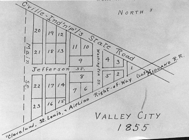
Vandalia Crossing -- sometimes it is hard to decide whether these are just literally a crossing in the road or if there were houses there indicating a community - we're counting this one as a community but if I have some nay votes it is not, I can always change it (kbz) -- thanks to Jerry again :) Although there were many roads crossing the Vandalia Railroad, one crossing bore the name "Vandalia Crossing." Came across this on the old postal map. The intersection of CR150S with Ladoga Road bears a distinct jog where it crosses Ladoga Road and it is at this crossroad that the Vandalia RR crossed too. You can still see the where the railroad went north from the crossroad today.
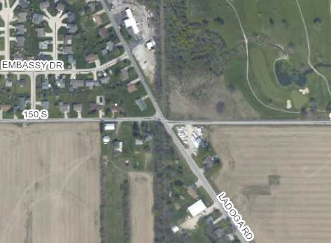
VanHook Hill -- this we think is the hill on the Big Four Arch Road where the Animal Shelter is. VanHooks owned land south to the Perrysville Road and from the Arch west past the Schenck Road. Here's a little bleep about it. Not sure of year. Thanks to Jerry T. for it
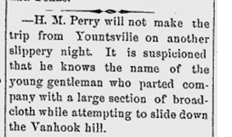
Vinegar Hill - : Source: . 1896 Argus News Sec 30/31 Walnut Twp - thanks Suzie :) Note from Suzie -- There is an article by John Bowerman in the March 1987 MM that says Vinegar Hill was on the Monon route just south of the present day overpass on State Road "43" - this was the most elevated point between Chicago and Louisville. This crest was known as Vinegar Hill. A resident, John Simmons, said there was a large number of fruit trees and believes this to be the reason for the area being given this name. Vinegar Hill remains another focal pint in oral history of a colorful county. So, if this is true - the area I thought was Vinegar Hill isn't. To add to this dilemma three-four historians and I were riding through the country and I was told the highest point in Montgomery County and the one mentioned above was south of Crawfordsville (Scott Twp probably) just north about a mile from Parkersburg so if that is true, then that would be Vinegar Hill. What a hoot !! Wonder where it really is. In the Weekly Argus News April 23, 1898 Vinegar Hill has several notations of people doing various things but underneath it, (Whitesville) is in parenthesis so it must be another name or it is very near Whitesville - kbz - see also Onion Town
Wabash College -- one of the few all-men's colleges in the US today it is close to 200 years old. See the Wabash College photo album on this site (scroll down after clicking the link), the Wabash College website.
Walnut -- Found in the Crawfordsville Review 17 October 1913 by Jerry T -- titled Walnut, Ind -- names mentioned are Charles Vaughn; Booher; Henry Swisher; H.C. Mitchell; Arthur Brown; A.C. Walters; Clint Chadwick; Will Smiley; James Swank; Walter Linn and Rudolph Werts. Jerry thinks it was likely where SR 32 crosses Walnut Creek - the Walnut Hills housing addition would be to the north of the bridge now.
Walnut Bend -- C'ville Review, Oct 7, 1924 - Fay Hurt and family took Sunday dinner with Guy Hurt and family and the two families spent the afternoon with Mr. and Mrs. Earl Thompaon west of New Ross. Buford Ebaugh and Misses Iris and Irene Mitcheltree attended the Greenwood reunion Sunday. Edwin Davis Hedge was out of school the first of the week on account of sickness.
Walnut Chapel- some of the names are showing up around Section 5 of Walnut Twp. - this is the Beckville area - there is a church showing up just south of Section 5 in Section 13 - maybe that was Walnut chapel - ...(on a current map it shows as Providence Church). - szb
Walnut Fork - a branch of Sugar Creek - located in Walnut Township near Linnsburg - (thanks to Suzie) - this has a community today
Walnut Hill -- I've found land owners in kinda a line across No Union & into Franklin. Its like the Garfield area straight East into Franklin's sec 14, & 15. I found reference to Walnut Hill in July 1899 CWJ.- from Suzie
Walnut Township - South and East of Crawfordsville - New Ross; Linnsburg and Mace are towns in Walnut. From 1878 Montgomery County Atlas -- "Walnut Township is very similar in surface and soil to Franklin Township flat tracts of land occuring in the southeast. Walnut Fork of Sugar Creek is the main creek. Cornstalk Branch forms in the south part and Raccoon touches in the SE. Of old settlers we find William Coddington, Henry Miller, John Roark, W. Bratton, anthony Beck, Solomon Beck, John Linn, E. Martin, John Smith, John Loop, W. LaFollette, J.B. Jesse, John Stipe, G.G. Warrinton; J.H. Harrison. The township is traversed by the IB & W Railroad. Fredericksburg (Mace PO daily mail) is a very prettily situated village, inhabited by a thrifty, industrious people and doing considerable business. Three-quarters of a mile south is the station of Mace, and a little village springing up around it named Linnsburg. Mace Station is the best watering place on the IB&WRR between Indianapolis and Covington. Meiser's saw mill is located here. One mile SE of Mace Station, a few lots are laid out as Clinesville. Fredericksburg was laid out in 1839; Linnsburg April 1870; Clinesville March 1870. The largest town in Walnut is New Ross. The town was first laid out in 1855, under the name of Valley City, although no valley is close to it. After the railroad was built, the town took a new start. New Ross was incorporated in 1874 as a town, covering 168 acres and having 252 inhabitants. Some of the able business is milling and stave and barrel manufacturing. Mail daily. Three and a quarter miles north of New Ross and four and three quarter miles east of Fredericksburg is Beckville, a hamlet that clusters around a sawmill.
Waterloo -- thanks to Jerry T for findin (Weekly News Review June 14, 1901) what we believe is another (380th) town in Montgomery County. Names mentioned are Elmer Irons, George Malsberry, Tarven Parker; Brent White and others, that are all in the 1900 Linden area (Madison Twp)
Waveland - located on State Highway 47, about 13 miles south of Crawfordsville -- read a history of Waveland by Mrs. Kleiser that was in the Waveland Independent newspaper for several weeks -- see also the Waveland Photo Album and the Waveland Blogspot (sports by Bill Boone - it's nifty) I also wrote a Waveland History you can read
Source: Greencastle Banner 16 April 1874 p 3
M. T. Lewman and Culross & McIntosh are doing the brick and stone work of a two-story block at Groveland, which will contain 7 business rooms. That village is improving. (Note – the next newspaper noted it is Waveland and not Groveland where the building was being erected. – kbz
Waveland Academy - a high school/post high school specializing in the Arts and Humanities in the center of Waveland - in existence in late 1800s - extinct -- this was quite a large and respectable academy and people came from miles around to attend
Waveland Road - 700 West going north out of Wavleand - connects with SR 47. This is the road going by the old Half-Way House
Wayne Township - Township West of Crawfordsville. The 1878 Atlas of Montgomery County, Indiana gives this description of Wayne Township - the surface of Wayne is gently rolling, but sometimes broken in the neighborhood of the creeks. In fertility its mulatto soil is equal to the best in the county; wheat averages 20 bushes per acres, corn 40 bushesls. The drainage is naturally good; in the east part into Sugar Creek the rest through Coal Creek Branch. The townsip was settled at an early date. Dennis Ball (fatherof James Ball); Abraham heath and his sister, Mrs. Mary Rush are the oldest settlers in Wayne Township settling in 1823, with their parents on Section 28; Andrew Shanklin's family 1827; Thomas Utterback's family, 1828; Henry Walters and family, 1828. The first church was te old Baptist in Waynetown in 1829 or 1830. The best wheat crops in this township were in 1864 and 1877 but in 1875 the grain crop failed entirely. This township was twice visited by heavy storms. A few years before the first settlers came a hurrican caused a windfall (known afterward as The Fallen Timber District) and again in 1877. Both times the direction was from northwest to southwest. Waynetown (Middletown, first called) was laid out in 1829 and is a very thriving country town on the I,B,& W Railroad. It was incorporated in 1873 as covering 148 1/2 acres with 270 inhabitants. Backed by a fine farming country, it is unnecessary to say that its business is in an active state. It has a daily mail. Wesley is a flag station and PO on the same railroad 2 1/2 miles SE of Waynetown.
Waynetown - on State Highway 136, just south of Interstate 74 - (many times referred to as Waynestown but this is NOT correct - it IS Waynetown.-- -- see the Waynetown Photo Album and the Waynetown Gladiators cool site by Bill Boone. See also the Waynetown school info on this site. See also Middletown - early history
Wayside - May 1896 a W.W. Watson is listed - but, owned property in Brown (Sec 3) & So. Union (Sec. 18). The Britsch family was listed several times too.
Welch Road -- N/S road between Parkersburg/Ladoga Road and Allnut Road
Welliever Hill -- on road 136 - the hill past the old drive-in theater. - thanks Suzie Q
Wellsville -- Source: Crawfordsville Weekly Journal 1 Feb 1895 “Wellsville news items” – include Strauder Peck; J. Finch; Bruce Morris; JM Walkup; Hannibal and Newton Finch; Robert Logan; Mell Foust and Tom Phillips. Anyone know where this might be? Kind of thinking near Ladoga ?
Wesley - Wayne Township - this was a train station with a few houses and a very active church and school -- not long ago (haven't been by there lately) the church and cemetery were still there - it is located on State Highway 136 West of Crawfordsville about half way between Crawfordsville and Waynetown on the south side of the road. Margaret S. White was appointed Post Mistress the first day of July in 1881, followed by another woman, Etta M. Rusk (29 August 1889) then John L. Miller 22 August 1890; Thomas J. Simpson 22 May 1891 and lastly David M. Phillips until closing.
Wesley Academy - located in the town of Wesley - a church high school. Now extinct
Wesley Station -- 250 North at 600 West(Christian Union Road & Covington Rd) - (center of Section 19) - 1.2 miles west of Wesley. Began in 1869 when the railroad went through (thanks Jerry T). S.H. Crowder was railroad agent there in 1874. A blacksmith shop, grocery store and post office was here.
West House - only mention I've ever seen of this place is in this short obituary : > Crawfordsville Weekly Journal12-8-1899
"West House News" -- Cora, the daughter of James and Sarah Shelton died Tuesday of consumption. She had been a sufferer for a long time, although she bore her suffering very patiently. Services were conducted at the house, north of Smartsburg Wednesday; interment at Smartsburg. so imagine it is near Smartsburg somewhere
West School House -- this could be one in the same place as West House above but found in different papers/times - does seem to be in the same area however - names found in the Crawfordsville Star 9-12-1895 were Oath Catterlin; Minnie Myers; Titus Long; Benjamin Long; Peter Barley; James Campbell; Mattie Shelton. I'm not counting this in our town total since I do feel it is probably one and the same place since Oath Catterlin lived in that area as did the Longs and Barleys. Shucks - this would have made 292, too :) Thanks to Jerry T for sending it though :)
Wheeler's Grove -- Crawfordsville Star Sept 6, 1883 p 8 lists Damas Wheeler and wife who are still living and nearly 90);
Robert Sayers; Orson Kerr and John Montgomery as pioneers of Wheeler's Grove.
White Church -- 22 Oct 1897 CWJ--This was about half way between Colfax & Linden on the now black top road just before the 2nd curve on the S-turn. Note the cool picture (click on name) sent by Lynne Ream. Her father was born near this church. The gathering is on the 4th of July 99 years ago (1915)-- Names in the CWJ 1897 listing are Sylvia Harshbarger Mrs. Margaret Caves (who was listed in Kirkpatrick) D.C. Campbell (Sugar Creek - section 10 in 1895 --- ?? 1897)- thanks to Suzie. Jerry Turner sent an article from the Weekly Argus News of 10-28-1899 with names such as Rettinger; Cobb; Cook; Campbell; Dunbar. -- 1878 plat map. The cluster with the White/Dunkard Baptist Church, the Bowers cemetery and the first Bowers consolidated school was at that S curve on the Linden-Colfax Road. I would estimate it to be 3 -3 1/2 miles west of Colfax.. (MEF) – Dan Dunbar added that the Bowers Cemetery is about ¼ mile north of 850E and 1050N to help ya’ find this better! Thanks Martha, Dan & all for the help
Whitlock -- this surprised me that it was near Wingate as it is assumedly named for one of Crawfordsville's earliest settlers, Major Ambrose Whitlock (there is a Whitlock Avenue named for him). Its post office began 7-22-1884 with Squire Gilkey appointed post master a few months later on the 29th of December, followed by Charles Webb not long before it closed (22 April 1889) and closed 5-15-1889 with the mail thereafter routed to Wingate.. Thanks Suz. To add a bit of info to Whitlock from the C'ville Star newspaper (thanks JT), 15 March 1888, we find the area excited about the upcoming election - "The Democrats of Coal Creek hold their township convention March 24, 1888. The Republicans have not yet named their day.... Politicians, especially those of Democratic proclivities, are on the qui vive at the present time. From all appearances, there are several who have the Trustee bee humming in close proximity to their respective heads.... It is intimated that neither Daniel Custer, Joseph Henry nor Aaron Gilkey would refuse the nomination for Trustee if tendered them. They can all unite on one classic phrase of "Barkus is willin." Most of the district schools commenced their spring term last Monday. Chas. A. McClure, the efficient weilder of the rod, presides over the school of this burg. Expansion of Cadwallader & Ocheltree -- "our meat men, have started a branch shop in New Richmond. At the same time they have renovated their shop here, and now can claim to have as neat a shop as any in the county. Articles in the Wingate listings explaining more about Whitlock/Wingate - thanks to Andy R for part of these ! Greatly appreciated!!
Whitesville - current home of Nucor Steele, found on County Road 500 South and 400 East - in the Jan 7, 1899 Weekly Argus News it states that "Whitsville contains 33 dwellings, one blacksmith shop, one barber shop, a store, a post office and two churches.
Wide Awake -- Source: Crawfordsville Review 26 Nov 1898 p 8
“Wide Awake” – people mentioned Frank Swank (Frank Delaney who is working for John Swank spent Sunday last with Wide Awake friends). Church as well attended here last Sunday .. Fred Maxwell will be our preacher. We saw in the Wide Awake letter last week that Eli Groendyke got left last Sunday night, but nit! He had one of Prairie Edge’s fairest girls and he marched her right into church. Under Lofland’s Crossing heading – “We see in last week’s issue that Wide Awake didn’t know how many votes the populist candidate for sheriff got … Well, Wide Awake ought to know that the democrats only count the votes of their own candidates!” Source: Crawfordsville Review 2 April 1898 – Under Prairie Edge’s article – The Wide Awake attorney, Frank Davis has rented the Walter Thompson house where Henry Shelley lives. Same source under “Wide Awake” John Vanarsdall and wife spent Sunday with Wilbert Breaks and wife. Thomas McClamrock has been busy since the big rains repairs bridges. What happened to the officers of this place? They do not attend to business. Last Friday night some tramps camped in front of Elias Francis’ and they asked Mrs. Francis to fry some “eggs for them.” She refused. When the fellow got back in the road he used language not fit to print. Francis was away from home or there would have been some hobos hung to a limb in Wide Awake. Last Sunday we took a stroll around the town of Wide Awake. Source: Crawfordsville Weekly Journal 3 Sept 1868 p 3 While other townships are being represented, through your columns by such characters, Perry Winkle, Polly Ann, Eyetemist, Wide Awake and Tom Tattler, a word from old Madison may be in place. Thanks to Hannah Gray on the Crawfordsville & Montgomery County History FB page, we know for sure about Wide Awake -- January 1st, 1898 in the Crawfordsville Review describes the village location in the social column. “Location of Wide Awake - Wide Awake is a small village about three and one-half miles north of Crawfordsville. Bounded on the East by the Monon railroad; on the south by Lovers Lane; west by the New Richmond Road and on the north by Cherry Grove.
Wigwam - SE of Mace Sec 20/21/22 area (Sam Conner, DD. Berry, Rutans - some of the names) - from SBZ
Wildcat Swamp -- an area near Mace pre 1900
Wildwood -- from Suzie -- here's her note: Guilliams, Rufus Myers, Joe Linn, Edith Morris, Joe Abbott & son Aben - I can "FIND" them & all live in Walnut in Census - but, the "atlas" to actually place the families is too many years both directions to actually put them on the "map!" Very frustrating - that is why I was hoping I could find "Wildwood" in a different newspaper & different year even - might help me! ?? ! And, another note: Guilliams, Rufus Myers, Joe Linn, Edith Morris, Joe Abbott & son Aben - I can "FIND" them & all live in Walnut in Census - but, the "atlas" to actually place the families is too many years both directions to actually put them on the "map!" Very frustrating - that is why I was hoping I could find "Wildwood" in a different newspaper & different year even - might help me! ?? ! We put this on facebook and KNOW someone found the exact location (Charlie Starnes I think) but I can't find the FB entry. SHUCKS -- from my memory it is just north of Mace. kbz
Willis -- 11 May 1880 - Crawfordsville Daily Journal - William Cook lives at Willis - 5 miles NE of Crawfordsville
Willow Bend - Source: Crawfordsville Review 9 Sept 1893 p 4
Article titled Willow Bend as the town title – people mentioned – James Remleys attended the World’s Fair. Elder Shuey preached at Youngs’ Chapel last Sunday. Riley Halstead is home from Spokane Falls, Wash after living there four years. DW Yeagley will build a tenement house on his farm at this place. Mrs. J. Murdock and son, Charles attended the GAR encampment at Indianapolis. Rev. JM Stafford preached his farewell sermon last Sunday at the Methodist Church at this place. AJ Sweeter has return from British Columbia where he has been working in the silver mines for the last three years. Anyone know where this is?
Willow Grove -- Section 20, South Union -- this would be just south of 300 South on 231 - on the left - there is an old cemetery there, was a school and a small community.
Wilson -- This one may have had the quickest Post Office opening/closing in the county -- opening on June 13, 1860 and closing the next month on the 7th - it is not known where this town was but it was listed as having a Montgomery County Post Office in the Postal History of Indiana. Thanks, Suz
Wilson School Road -- 200 South
Wingate - on State Highway 25, North and West of Crawfordsville in Coal Creek Township. See also the Wingate school on this site and Bill Boone's awesome Spartan site. See Waynetown or Waveland or Ladoga above for the photo albums -- sorry, I do not have one for Wingate - anyone have any COOL PICSof the place you'd like to share ?? Articles regarding Wingate -- Pleasant Hill became the town of Wingate in 1881, named for John C. Wingate, who had brought many jobs to the town via railroading. The Clover Leaf dignataries agreed readily since there was another Pleasant Hill in Ohio but on their Clover Leaf Road. This would help with confusion. It was somewhat but not long afteward that the US Postal Service changed the name as well, again to prevent confusion. Read Wingate's biography
Wisehart Hill -- Section 31 Franklin Twp - May 1881 newspaper article (thanks, Suz)
Woodlawn -- In the February 1895 local newspapers, Suzie found these names "- Jno. Trimble - Sec 21 of Franklin -- at least this is where this guy is --- - SE of Darlington betwseen Darlington and Shannondale. There is a J.H. Stewart in Sec 22 of Franklin & Albert Tribbett in Sec 23 of Franklin ... Other names are: Kashner; Hall; Butler and Watkins. Source: Crawfordsville Star March 28, 1889 - Will Carter is farming for R.H. Virts; Joseph Francis is working for W.J. Mullen. Willard Booher will farm for Sam Shafer this summer. James Williams has been ditching for the Stewart Brothers. A.D. Kellison has been taking the enumeration of Franklin Township. A son of Miles Castor from Kentucky is visiting at BE Casters of North Salem. Flat Creek will bore for gas in the near future. The well will probably be located on what is known as the Elston land. Source: Crawfordsville Star July 14, 1887 - The social at Wm. Mount's last Friday night was a complete success. - J.H. Trimble is hauling lumber to build a new house. Decker & Son hav ethe contract. -- James Wright and wife of Crawfrodsville, spent Saturday and Sunday with Mort Stewart. -- Charles Butler and lady and W.C. Stewart and lady attended the pinic at Darlington last Sunday.
Wringneck (Wring-Neck) -- a community in the northwestern part of section 11 of North Union township, north northeast of Crawfordsville on county road 500 north. There was a school no 1 there and in the clippings talk of possibly building a steam saw mill by a Mr. Hall and Mr. Williams. I found a mention of the Wringneck Darlington Gravel road being completed but can't find it now. The names from the clippings, Willis Jackman, Joe Patton, Owsley, and G. W. Conrad match the 1878 atlas map I have for this region. It does not look like a village but a small community. I do see a cemetery marker on the old 1878 map but on the Library cemetery locator it does not show a cemetery. Jerry T :) You rock, Jerry - thanks so much for a new place I've NEVER heard of before :) KZ. Jerry sent more information from a July 5th 1870s Crawfordsville Star article mentioning "Dawson School House that must have been in the vicinity. Also "There seems to be quite a disturbance in this community as to where the new school house shall be located." Mr. Jackman evidently thinks Jackman's school house would be good. My fav part of this bleep on the little town was "The Wring-Neck boys say that Darlington correspondent is mistaken in regard to them taking the "Darling" part of Darlington - it is the other way, Darlington is trying to take the "Darling" part of Wring-Neck." Funny. Also found that Canine & Company will move their saw mill from this place to Waveland soon. A fairly good description is noted: "Wring-Neck is situated three miles west of Darlington and 7 miles northeast of Crawfordsville. It consists of one saw-mill, one school house and one blacksmith shop. (note above it looks like the sawmill is moving out :( )
Yangtsekiang - Sections 21-23 & 26-27, Franklin Township. Names in Yangtsekiang area are JA Mount, JH Trimble (March 1894 large landowners). - thanks, Suz
Yankeetown -- Yankeetown was located along what is now State Road 32, in Sections 32 and 32 of Franklin Township. It is almost halfway between Smartsburg and Shannondale. The Middle Fork of Sugar Creek was on the north side of Yankeetown. School number 5 was the local school and I believe it was called the Morris School. In 1881 the teacher was Miss Ella Maxwell. Issac Birson built a new home and a Blacksmith shop in 1881. The village had a few racehorses too. George Lafollete owned a trotting horse called Bald Hornet and Sherman Trout owned a pacing mare called Nellie Gray. some other notable residents or owners of the land in the 1880's were H. Trout, A.B.Caster, Robert C. Craig. THANKS to Jerry Turner, my town guru! Also Jerry says, Beckworth's history of Franklin township he has this: "There was a settlement, opening up in the south part of what is now Franklin township, on the waters of Middle fork, Sugar creek. To these were added, before the year 1830, Atwell Mount, Aaron Stewart, Samuel Flannigan, Joseph Cox, Henry Wisehart, James Tribbett, Elisha Cox, Jacob Booker, James Hopper, James McClaskey, Robert Craig, Enoch Peacock, Solomon Bond, J. C. Remley, and a few others. " I am thinking he was writing about Yankeetown then although he did not name the settlement. In his biographies about Robert C. Craig he says his father Robert Craig settled in Franklin Township in 1825 on the farm now owned by John Hutchings. This farm is in section 32 and 33 on the Middle Fork of Sugar Creek. See imagine Jerry T sent by clicking HERE
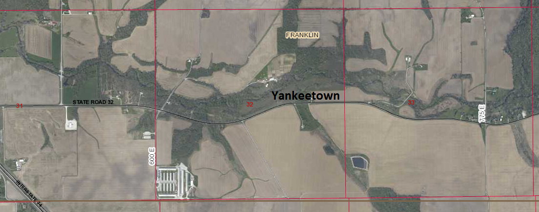
Youngs Chapel -- near Cherry Grove, Montgomery County. In 1870, Perry Swisher, 20 year old son of George Swisher died and was buried there - Union Twp - thanks to Jerry T for this one! Also, this may have basically been a church and perhaps a house or two.
Youngsville -- on 1853 Colton Map in Montgomery County, Indiana - thanks KZ
Yountsville - on Highway 32 South and West of Crawfordsville