
Land
Welcome to
Montgomery County, Indiana
Montgomery County, Indiana
Land Transactions
Land Records, Sales Notices from the Courthouse, Newspaper, the Landowner's Index of Names and the 1878 Montgomery County Atlas are most of the sources used for the following land transactions
Great link to maps, atlases of Montgomery County ... (thanks JDG for the suggestion) - kbz
General Land Sales
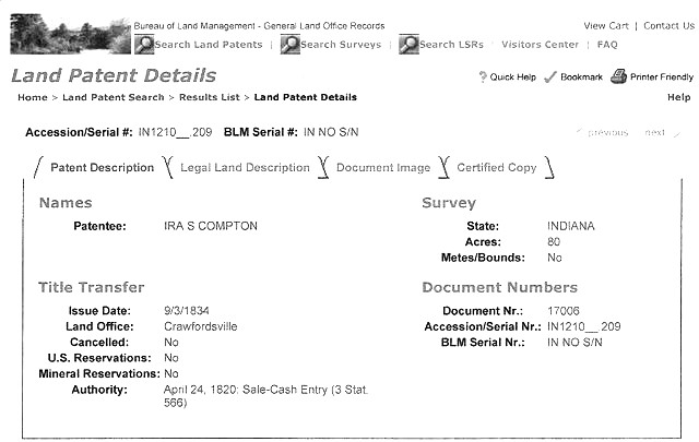
U.S. Government Land Office - search here for original land transactions for Montgomery County
GOVERNMENT LAND OFFICE RECORDS (C'ville LO)
From: Wesley Wilson Date: Wed, Feb 27, 2013 at 11:47 AM Subject: Fwd: Release: Historical Crawfordsville Land Office Index Now Available Online To: Date: Wed, Feb 27, 2013 at 9:49 AM Subject: Release: Historical Crawfordsville Land Office Index Now Available Online To: INDIANAPOLIS (February 27, 2013) – New material from the Crawfordsville Land Office has been made available through the nationally-recognized Indiana Digital Archives (digitalarchives.IN.gov). The Crawfordsville Land Office Index includes more than 38,000 records of purchases of public lands from Benton, Boone, Carroll, Clay, Clinton, Fountain, Hendricks, Monroe, Montgomery, Morgan, Owen, Parke, Putnam, Tippecanoe, Vermillion, Warren, and White Counties. Sales of public land at the Crawfordsville Land Office began in September of 1820 and continued until 1853. Thanks to Jodie & Dellie at CDPL for passing this on!
Montgomery County Court Sale of Land
HENDERSON OLIVER - estate land sold -- also mentioned Emeline Oliver; Julia Wineland; Henrietta Trotter; Levi Trotther; Milton Wineland; Elizabeth Wineland; Frederick Wineland
1878 Montgomery County Atlas & 1874 People's Guide
Land Sales
Jones, Resin V -- see Thomson, John
McINTYRE, Dugald (guardian - will)
Oiler, John - court-appointed sale of land - 1834
Thomson, John - property for sale
POPULATION---
Year / # / %
1830 7,317 —
1840 14,438 97.3%
1850 18,084 25.3%
1860 20,888 15.5%
1870 23,765 13.8%
1880 27,316 14.9%
1890 28,025 2.6%
1900 29,388 4.9%
1910 29,296 -0.3%
1920 28,490 -2.8%
1930 26,980 -5.3%
1940 27,231 0.9%
1950 29,122 6.9%
1960 32,089 10.2%
1970 33,930 5.7%
1980 35,501 4.6%
1990 34,436 -3.0%
2000 37,629 9.3%
2010 38,124 1.3%
2020 37,936
2020 37,936