|
TRAIL |
 |
|
TRAIL |
 |
The army resumed its march for The Prophet's Town on the following day. It consisted of about 910 men, composed of 250 regular troops, under Col. John P. Boyd; about sixty Kentucky volunteers; and some 600 volunteers from the Indiana Territory, including companies organized at Corydon and Vincennes, and other points along the Wabash and Ohio rivers. Of these about 120 were dragoons.
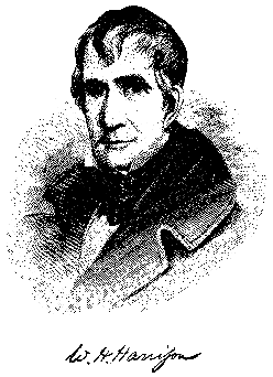
There were two routes leading to The Prophet's Town in general use by the Indians; one on each side of the Wabash river. The one on the left, or southeast side was the shorter, but lay in a wooded country where the army would be exposed to ambuscade. The route on the right, or northwest side of the Wabash, presented less opportunity for such attacks, and was therefore preferred by General Harrison, over which to conduct his army. In order to deceive the Indians if possible, General Harrison caused the road on the southeast side of the river to be reconnoitered and opened into a wagon road. The army started from Fort Harrison, moving up the east bank until it had crossed Big Raccoon creek. But suddenly, on the 31st, he crossed the Wabash near the site of the present town of Montezuma, Parke county, and took the other trail. On the 2d of November, the army built a block-house about twenty-five feet square, in a small prairie, at a point on the west bank of the Wabash, nearly three miles below the mouth of the Big Vermillion river. At this post a guard of eight men and a sergeant were stationed for the purpose of protecting the boats, which up to this place had been used in the transportation of supplies. The army proceeded on its march, there being no incident worthy of mention until it reached Big Pine creek in Warren county. This stream was bordered by high, rocky bluffs, covered by cedar and pine trees. The defile through which the army would have to pass in going down into and coming up out of this stream was long and narrow, and afforded an opportunity where a few men might successfully dispute the progress of his entire army. The Indians had twice availed themselves of this pass in opposing expeditions sent against them. First, in 1786, against an expedition led by General Clarke.
General Harrison halted and sent forth a reconnoitering party to find a crossing where his army would be less exposed to attack. A ford, evidently used by the Indians, was found further up the stream, on the border of a prairie country. The beauty of this region, stretching away to the northwest, toward the Illinois river, a distance of about 100 miles, was viewed by the soldiers with great admiration. The Big Pine was crossed in safety. No Indians were seen until the army had well nigh reached The Prophet"s Town.
On the night of the 5th of November, the army encamped near the present village of Montmorenci, in the western part of Tippecanoe county, about ten miles from The Prophet's Town. On the following day the march was resumed. Indians were seen lurking about, and the interpreters in front of the army were instructed to interview them. The Indians refused to talk, and replied only with defiant gestures. At 2 o'clock in the afternoon of the 6th of November, the army arrived within about a mile and a half of The Prophet's Town. General Harrison was urged to make an immediate attack. But his instructions were to avoid hostilities, if possible, and he still hoped for the arrival in his army of the deputation of friendly Indians, which he had sent while yet at Fort Harrison, concerning whom nothing had been heard or seen. General Harrison sent Captain Dubois, accompanied by an interpreter, forward with a flag of truce. The Indians refused to converse with him, and endeavored to cut them off from the army on their return. Harrison determined to encamp for the night, and started in search of suitable ground. When he had almost reached the town, The Prophet sent forward a deputation of three Indians, including his chief counselor. With much pretended innocence they inquired why the American army had approached so near their town. They disclaimed all hostile intentions, and told Harrison that The Prophet had sent a pacific message to him by the friendly Indians, who had returned to Fort Harrison by the road on the southeast side of the Wabash, and had by that cause failed to meet him. It was arranged that General Harrison should meet The Prophet on the following day and conclude a treaty of peace. He inquired of the Indians for a suitable camping ground, where the army could have plenty of fuel and water. They referred him to a site on a creek northwest of the town. Harrison dispatched two of his officers, Majors Marston G. Clark and Waller Taylor, to inspect this ground. After an examination, they reported everything satisfactory, and the army went into camp for the night.
Source: The Battle of Tippecanoe by Reed Beard, 1911
**Marker was located on county road 800 W. near Montmorenci in Shelby Township, but is now missing.
©1998-2014 Tippecanoe
County INGenWeb Project
All rights reserved.