
|
|
||
|
Newton
County Map |
||
| Pilot Grove | The Amish Settlement | |
|
Newton County Courthouse |
||
| 3 National Highways | ||
|
|
The original Newton County was
formed by statute on February 7, 1835 and was a roughly square area some 30
miles on a side, encompassing what is now the northern half of the county, the
northern half of Jasper County, and a large section to the north. The northern
border was cut back to the Kankakee River on February 1, 1836, with all land
north of the Kankakee River going to Lake and Porter counties. The county was
abolished and combined with Jasper County in 1839. On December 8, 1859, Newton
County was re-created, and the borders were redrawn to essentially their
current state.
Gov. Willard appointed Thomas R.
Barker as organizing Sheriff who then issued a special election to be held
April 10, 1860, for county officials. On April 21, 1860, the officers elected
were declared qualified to perform their duties by Barker.
Newton County is named after Sgt.
John Newton, who served under Gen. Francis Marion, the “Swamp Fox”, in the
American Revolutionary War. It is adjacent to Jasper County, which was named
after Sgt. William Jasper, whose story is similar. At least four other states,
Georgia, Mississippi, Missouri and Texas, have adjacent Jasper and Newton
Counties, as though these two were remembered as a pair.
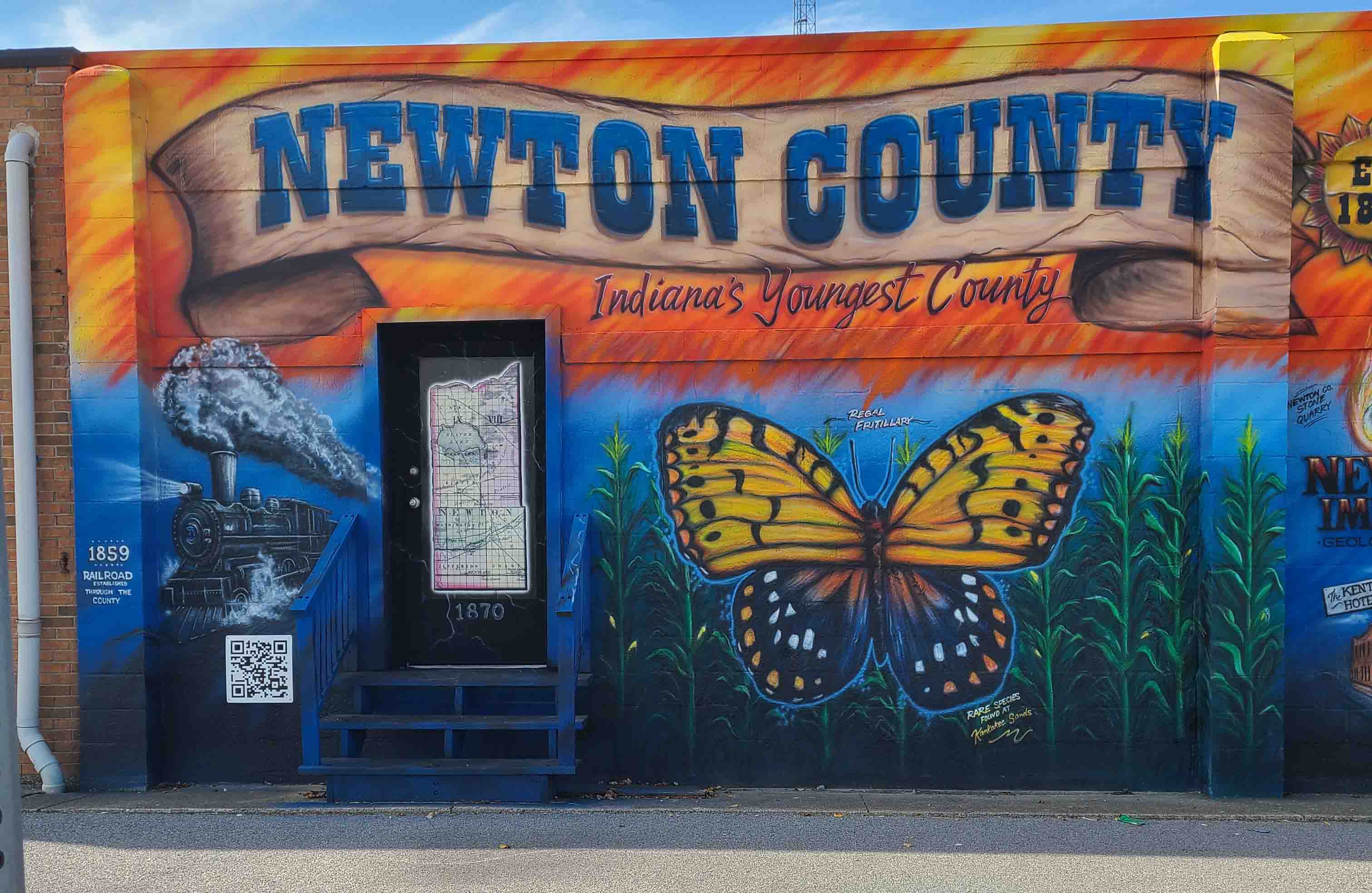
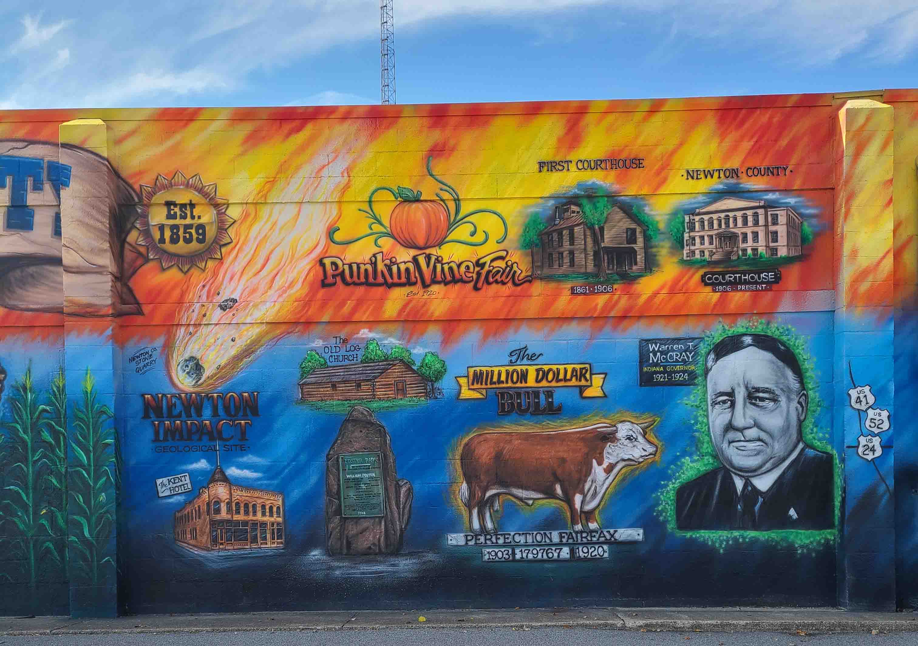
Newton County was the last county to be organized and is “Indiana’s Youngest County.”
Newton County Map
In 1860 there were five townships:
Lake (Twp. 31N, R9 & R10); Beaver, (Twp. 29N, R9 & R10); Washington,
(Twp. 28N, R9 & 10); Jackson, (Twp. 29N, R8); Iroquois, (Twp. 28N, R8).
Other Townships formed: 1860, Jefferson (Twp. 27N. R9 & 10); 1862:
McClellan, (Twp. 30N, R9 & R10); 1865: Grant, (Twp. 27N, R8); 1871: Colfax,
(Twp. 30N, R8); 1872: Lincoln, (Twp. 31N & Twp. 32N, R8).
1831-33, the Brook Settlement. Towns
platted: 1851, Morocco by John Murphey; 1860, Kentland by A. J. Kent; 1861,
Goodland by William Foster; 1866, Brook by S. H. Benjamin; 1876, Lake Village
by Richard Malone; 1882, Roselawn by Craig and Rose; 1882, Julian, by J. B.
Julian; 1882, Foresman, by J. B. Foresman; 1905, Conrad by Jennie Conrad; 1906,
Ade, by W. T. McCray; 1907, Enos by R. & L. Bartlett; Sumava Resorts, 1927,
Dvorack and others.
To the North, the Kankakee
Indian name: “Au-ki-ki”
The Kankakee rises near South Bend
and flows southwestward in a straight channelized course created by dredging in
1911. It is the northern boundary lines for Lincoln and Lake Townships and
separates Newton and Lake County.
To the South, the Iroquois
Indian name: “Pinkamink”
The Iroquois rises in Jasper County
and flows generally west-southwestwardly entering Newton County in Jackson
Township through Jefferson Township.
Beaver Lake, the largest body of
water ever to be known within the confines of the State of Indiana in modern
times is now a thing of the past. It was a natural water area seven miles by
five miles in extent, a placid lake of 15,000 acres located six miles south of
the Kankakee in McClellan Township. It was muck bottomed and shallow except for
a narrow 12’ channel through it. Reeds, grasses, and pond lilies grew rank in
most of the primitive waters and a few islands were located amongst the waters.
Wildlife concentrated at the lake in
great numbers including white swans, ducks, and geese along with cranes and
herons of many kinds and a variety of bird breeds. Residents of the past recalled
the many beaver dams that were seen in various parts of the lake, one reported
to be more than a mile in length.
First attempts to drain the lake
began in 1854. In 1873 the “big ditch” was dug out and completed the draining
of Beaver Lake into the Kankakee.
The largest island in Beaver Lake
was known as Bogus Island, named for the horse thieves and counterfeiters who
used it as a hide-out from 1830-1858. They made counterfeit coins and hid
stolen horses on the northwest end of the island, where a precipice 25’-35’
high was carved from the northwest winds blowing across the lake. It sloped
south to southwest, covering approximately 13 acres in length. The only access
was from the north end via sandbars.
Bogus Island comprised forty acres and
was densely overgrown with oak trees. It was surrounded by an almost bottomless
marsh, making the task of reaching it from mainland extremely difficult and
dangerous.
In 1857, a group of vigilantes from
the area, met at the home of Captain Thomas Rogers Barker, located at the south
shore of the lake. They devised a plan for removal of the outlaws but was never
carried out. After the arrest of William Shaffer, one of the meanest bandits of
the area, the remaining outlaws fled in fear of arrest and never returned.
In 1859, the Logansport and Peoria
railroad track was built between Logansport and Peoria, IL, ran the first train
through Goodland and Kentland on December 25, 1859.
The “Big Four” built a railroad
through the southwest corner of the county in 1871. The Monon railroad was
built through Roselawn and the northern part of the county in 1878. In 1882,
the Chicago, and Eastern Illinois, (C.& E. I.) built a railroad through
Goodland, Foresman, Julian, and Mt. Ayr.
The “Three I” railroad was built
through the northern part of Lincoln Township in 1883. In 1888 a branch of the
C. & E. I. was built through Brook and Morocco. As these railroads were
being constructed many towns and villages sprang into existence.
The massive expanses of cultivated
prairie ground throughout the county have continued to provide the farmers with
productive fields of grain for markets and pasture for livestock. Many tons of
specialty crops such as mint and farm produce have been shipped from Newton
County through the decades. Frog legs and oysters from the Kankakee marshes
were a specialty of the Chicago restaurants in the early 1900s.
The Regal Fritillary
Butterfly
McClellan Township
Standing in front of the mural, you
can pose between the wings of the endangered Regal Fritillary Butterfly. The
Kankakee Sands, as a region, both in Indiana and Illinois is a hotspot for the
rare butterfly. Late June and early July is the prime time to see them.
The male Regal Fritillary has two
rows of spots on the hind wing; the female would have two rows of white spots,
while the male has an outer row of orange spots. Which are you posing with?
Not too long ago, the regal fritillary was only found in one preserve in the state of Indiana. Kankakee Sands was built around that site with the hope that restored surrounding habitat might allow the butterfly to expand out to new habitat, grow its population and thrive as a species.
Newton County Courthouse(s)
Iroquois Township
In 1837 the present Benton, Jasper
and Newton counties were one. The county seat was in Pine Twp. The first board
of commissioners met at the home of Robert Alexander in Parish Grove in 1838.
Its members were Amos White, Joseph Smith, and Frederick Kenoyer. At their
first session it was ordered that the Circuit Court, Probate Court and
Commissioner’s Court be held hereafter at the house of George W. Spitler,
provided that the majority of Pine Township residents be in favor of it. Amos White
took a petition to every voter in the township asking to sign either for or
against removal. Sixteen signed in favor and eight against said removal.
The explanation of the transfer of
the county seat to a smaller settlement in the northern edge of the territory
was to accommodate Mr. Spitler, who had been elected clerk and had refused to
act unless the place of business was brought nearer to his residence. The
commissioners agreed and in March 1839, met at Mr. Spitler’s house, located
south of present-day Brook about 2 miles. In 1974 a landmark was placed at the
site of Newton County’s first courthouse.
Newton County First
Courthouse
Jefferson Township, built 1861
In March 1861, a bid of $1,000.00
was made by J. B. Chesebrough for a Newton County courthouse. It was to be a
plain structure with court and jury rooms above and four offices below, held by
the Clerk, Auditor, Recorder and Treasurer. In June 1861, the building was
completed and accepted.
Jefferson Township, built 1906
On February 1, 1904, the County
Commissioners condemned the courthouse building and ordered a new structure to
be built for $25,000. After year-long meetings and discussions, the
commissioners ordered the appropriation of $25,000 by the Council for the new
courthouse, making the final order for the erection of the building. On August
6, 1906, after many months of debate on contractors, cost and political push
and pull, the present-day courthouse was complete and accepted.
Jefferson Township
The iconic turret tower of the Kent
Hotel has stood prestigiously above the downtown business district of Kentland
since 1894. Dubbed as one of the most modern structures in town at that time,
the building boasted its first floor offered 20’x20’ office space; 22’x40’
dining room and a 20’x76’ kitchen, laundry, ware room, commercial men’s sample,
and business room. On the second floor there was a parlor, sitting room, and
twenty large guest rooms well ventilated and lighted. The building was furnished
with the “East Lake” style and fully heated and lighted on a modern plan.
Today, it is no longer a hotel but
the home of a fine dining restaurnt named the Old Colonial Inn.
Jefferson Township
Mt. Newton, the Kentland Dome, and
presently the Newton Impact Geological Site are names that evolved through the
years for the rock formation abnormalities at the stone quarry located along
U.S. 24 east of Kentland.
The quarry opened in 1865, when
Samuel Means and John McKee purchased lands adjacent to each other in that area
and operated two quarries - McKee on the east and Means on the west. By 1906 a
third quarry was operating between them, owned by W. T. McCray, and operated by
Vanetta and Evans. In 1928, McCray sold it to George Hart, who in 1946 sold it
to Ralph Rogers and Co., Inc. Rogers would name it Newton County Stone. It
eventually expanded to include the Means and McKee properties.
After the melting of the vast
continental glaciers during the Ice Age, a thick mantle of rocks, gravel, sand
and silt and mud were left behind by the melting ice exposing in places
throughout Northern Indiana underlying bedrock. The Newton County quarry was
one of these places. The abnormalities of the site begin with the age of the
stones quarried at the site. Ancient rocks from the Ordovician age - 360 to 440
million years old are exposed at the surface and have been quarried for many
years. Bedrock normally cropping out to the surface is the area that belongs to
the Mississippian Period – more than 240 million years old.
Nor do the rocks slope to the
southwest as they normally do in Northern Indiana. These beds dip randomly at
very steep angles and even stand vertically. They have been crushed in places
and bent into folds and broken by faults in the rock. Even small grains of
quartz – one of the strongest of common minerals, have fractured and show
evidence of great stress. Nowhere else in Indiana are rocks known to be
deformed to this degree.
Many theories have been discussed
over the decades, but the Meteorite Theory seems to be the best scientific
explanation. In 1936 geologists from all over the world suggested that some of
the crypto volcanic structures, such as Newton County’s Kentland Dome,
represent areas where rocks have been disturbed by the impact of a meteor. They
pointed out that after a large meteorite strikes the earth the suddenly
compressed rocks will expand with explosive violence and the shatter them.
When the meteorite hit studies show
that it was ½ to 1 mile in diameter. The stones being mined there today should
be 2,000 ft. below the surface, but the impact blasted the rock to the surface,
standing it on its end. The entire event probably occurred with a time span of
2-3 minutes. Shatter cones, common to a meteorite impact have been found at the
quarry – validating the theory of a meteorite falling to earth and creating the
anomalies found at the quarry.
The studies continue today as to the
origins of the anomalies of the Newton County Stone quarry.
Grant Township
Named for the founder of Goodland,
William Foster, (1813-1908) who arranged the necessary monies for the
completion of the Toledo, Logansport, and Burlington Railroad as it struggled
to complete its road from Logansport to the Indiana-Illinois line by January 1,
1860.
Thomas Mitten, who was planning to
build the Mitten Memorial Library in 1929 paid tribute to William Foster by
placing large glacier boulder, weighing 10,000 lbs. and 8.5’ long and 4’ at the
base facing U.S. 24. The stone itself resembles that of a mitten.
A public park is an integral part of
the Newton County communities. They serve as a place for family reunions,
events and festivals, playgrounds for young and old, or just a place to sit and
relax and read a book.
Grant Township
For 12 years, Perfection Fairfax
ruled over Warren T. McCray’s Orchard Lake Stock Farm, its 1600 acres and 500
head of registered Hereford cattle. During the farm’s hey-day 1910-1920,
Orchard Lake Stock Farm was a national showplace, a small empire that had a
baronial mansion and a headquarters complex of more than a dozen buildings.
Perfection was born Oct. 10, 1903,
and was crowned Grand Champion in the 1907 International Livestock Exposition.
McCray purchased Perfection Fairfax in Scotland in 1908 for $25,000. As herd
bull, Perfection fathered many champions. One sale at Orchard Lake Stock Farm
sold $565,000 worth of Hereford cattle.
When Perfection died in 1920, McCray
buried him atop a catalpa tree ridge that rises out of the flat prairie
farmland. It is located six miles northeast of Kentland at the former site of
McCray’s Orchard Lake Stock Farm. The 8’ high concrete tombstone with flagpole
is the final resting place of Perfection Fairfax, a Hereford bull nationally
famed as “King of Hereford Sires”.
Jefferson Township
Warren T. McCray began working as a
bookkeeper at the age of 15. At the age of 21 he went into the grocery business
and then began grain trading, becoming one of the organizers of the National
Grain Dealers Association.
He purchased acreage northeast of
Kentland in Grant Township that would develop into a 1600-acre farm known as
Orchard Lake Stock Farm. It had a reputation as a multi-million-dollar
operation based upon the purchase of his prized Hereford bull, Perfection
Fairfax.
McCray was a community-oriented man,
dedicated to the development and prosperity of his hometown of Kentland. In the
fall of 1920, he was elected the 30th Governor of Indiana.
In 1924, convicted of mail fraud,
McCray resigned as governor and served three years in federal prison, and was
fined $10,000. He was paroled in 1926. In 1930, he was granted a full pardon by
President Hoover.
McCray returned to Kentland where he
began to rebuild his farming operations. After suffering a heart attack, he
died in December 1938 at the age of 73. He is buried at Fairlawn Cemetery in
Kentland.
The First Newton County
Church
Washington Township
As early as the 1820s or early 30s
the United Brethren missionaries and pioneer preachers held services in Newton
County. In 1836 Jacob Kenoyer settled near Spitler’s Creek, a northern
tributary of the Iroquois River. Here he erected a sawmill and corn cracker as
a means of livelihood. His brother Frederick and other members of the family
arrived soon afterwards and settled north of the Iroquois River near the
present-day Newton County Fairgrounds land. Closely associated with the Kenoyer
family was the John Myers family and the neighborhood became known as the
Kenoyer/Myers settlement. Jacob and Frederick’s religious convictions became
stronger than their business instincts and they became widely known as
preachers and exhorters of the United Brethren Church.
The first church built in the county
circa 1839 was on the farm of Frederick Kenoyer, north of the Iroquois River.
It was located on the north side of CR1150 S, just west of US 41, after the old
railroad tracks on the north side of the road. Before the building of the
church, services were held among the homes and schools of the community.
Upon completion it was about 20’x30’
with 8’ ceilings; faced the south with one window in the north, two in the
west, two in the east and a door in the south. The seats were benches made of
split logs and the pulpit was rather high.
A historical marker was placed at
the site in 1976 by the Kentland Chapter NSDAR.
Newton County Pun’kin Vine
Fair
Washington Township
After the successful 1920 and 1921
Newton County Fair at Brook, it became evident a larger site for growth and
expansion would be necessary for future events. Land adjacent to the Newton
County Home was chosen as the official site for the third annual Newton County
Fair in 1922.
The how and when the name evolved
into the Newton County “Pun’kin Vine Fair” is open to debate. Some say that the
entry gates for the first fair were covered with pumpkin vines – others say
that remarks were made that the fairground land was only fit to raise
“Pun’kins.”
Through rain or shine, good times
and bad, the fair continues to be one of the most celebrated weeks for Newton
County residents.
McKinley Park/Military
Contribution
The image of the monument to the
Civil War Veterans in McKinley Park in Brook is but one of the many monuments
erected throughout the county honoring those who have served in the military.
Each community have designated locations for this purpose. All gave some. Some
gave all.
Jefferson/Iroquois
Townships
George Ade was, at one time, one of
the most famous writers in the country, and Newton County was and still is
proud to call him one of their own. Born in neighboring Kentland, Indiana on
February 9, 1866, he graduated from Purdue University in 1887. In the years
after graduation, Ade became a journalist for several different newspapers.
He eventually built his fortune on a
string of successful plays, books and newspaper publications in the early
1900’s. Ade had a sharp, satirical humor which was often focused on the events
of the day. He began his career as a newspaper writer but soon moved on to
other endeavors. At one time Ade had three plays on Broadway simultaneously.
His most successful and probably best-known productions were The College Widow
and The County Chairman. His writing is usually compared to Mark Twain’s
because both authors possess elements of humor, rustic charm, and small-town
morals. Ade was referred to as “The Aesop of Indiana.”
“I am a bachelor, but I prefer to
live in my own home. My enthusiasms include golf, travel, horse-racing, and the
spoken drama. My antipathies are social show-offs, bigots on religion, fanatics
on total abstinence, and all persons who take themselves seriously. I love to
put on big parties or celebrations and see a throng of people having a good
time.” — George Ade on George Ade
Iroquois Township
The mansion completed by George Ade
in 1904 is an Elizabethan manor house.
Ade purchased over 400 acres
around the property East of Brook and thought the grove of oak trees near the
Iroquois River was a “nice spot to put a little cottage.” The little cottage,
which he envisioned as his escape from the busy Chicago writing scene at the
turn of the 20th century, manifested itself into a grand estate. The property
was a working farm with a cow barn and several smaller outbuildings along with
a caretaker’s cottage. But the property also served as a recreation’s paradise
with a softball diamond, swimming pool and elaborate gardens. Ade even created
a garden in the shape of the state of Indiana itself. The home was decorated
with the remnants of Ade’s travels East and features rich dark woodwork and
large windows.
The
author enjoyed entertaining and hosted many parties for area residents.
Conventions for his fraternity Sigma Chi and political receptions were also
held at the estate. President William Howard Taft announced his campaign for
the White House at a rally at Hazelden in 1924. The playwright found any event,
from the most mundane local signage change to the grander national announcement,
as a reason to organize a celebration.
Hazelden is on the National
Register of Historic Homes. The home and property are owned by Newton County
and are managed by the George Ade Foundation.
South Newton School
Corporation
South Newton High School is a
multi-community high school consisting of grades 9-12 located in rural Newton
County, between the incorporated towns of Kentland, Brook, and Goodland,
Indiana. The Elementary and Middle School facilities are located adjacent to
the high school.
The corporation was formed in 1961
with R. D. Norris as Superintendent. Classes began at the new school in 1966.
The school mascot is the Rebels; school colors are red, gray and white; the
annual yearbook is called “The Regiment.”
Beaver Township
They called him Baseball’s “Man O’
War” because of his military service and because of his fleet-footed fielding
and base running. He is arguably one of the greatest athletes to be born and
reared in the Newton County area.
Rice was a pitcher and outfielder in
Major League Baseball. Although Rice made his debut as a relief pitcher, he is
best known as an outfielder, playing for the Washington Senators from 1915
until 1933. He led the American League in stolen bases in 1920. He led the
Senators to three postseasons and a World Series championship in 1924. He
batted left-handed but threw right-handed. Rice played his final year, 1934,
for the Cleveland Indians. He was elected to the Baseball Hall of Fame in 1963.
Batting Average: .322; Hits 2.,987; Home Runs 34; Runs batted in 1,078.
His story is one of glory on the
playing field yet colored by sadness, as he is linked to what is considered to
be the greatest natural tragedy to ever occur in Newton County. On April 21, 1912, while in Galesburg,
Illinois for a baseball tryout, his home and family took the full brunt of a
tornado. Seven Rice family members including Sam’s wife and children were
killed by the storm, and later his father, Charles Rice succumbed to his injuries.
Sam would turn his full attention to baseball and never return to the Newton
County area.
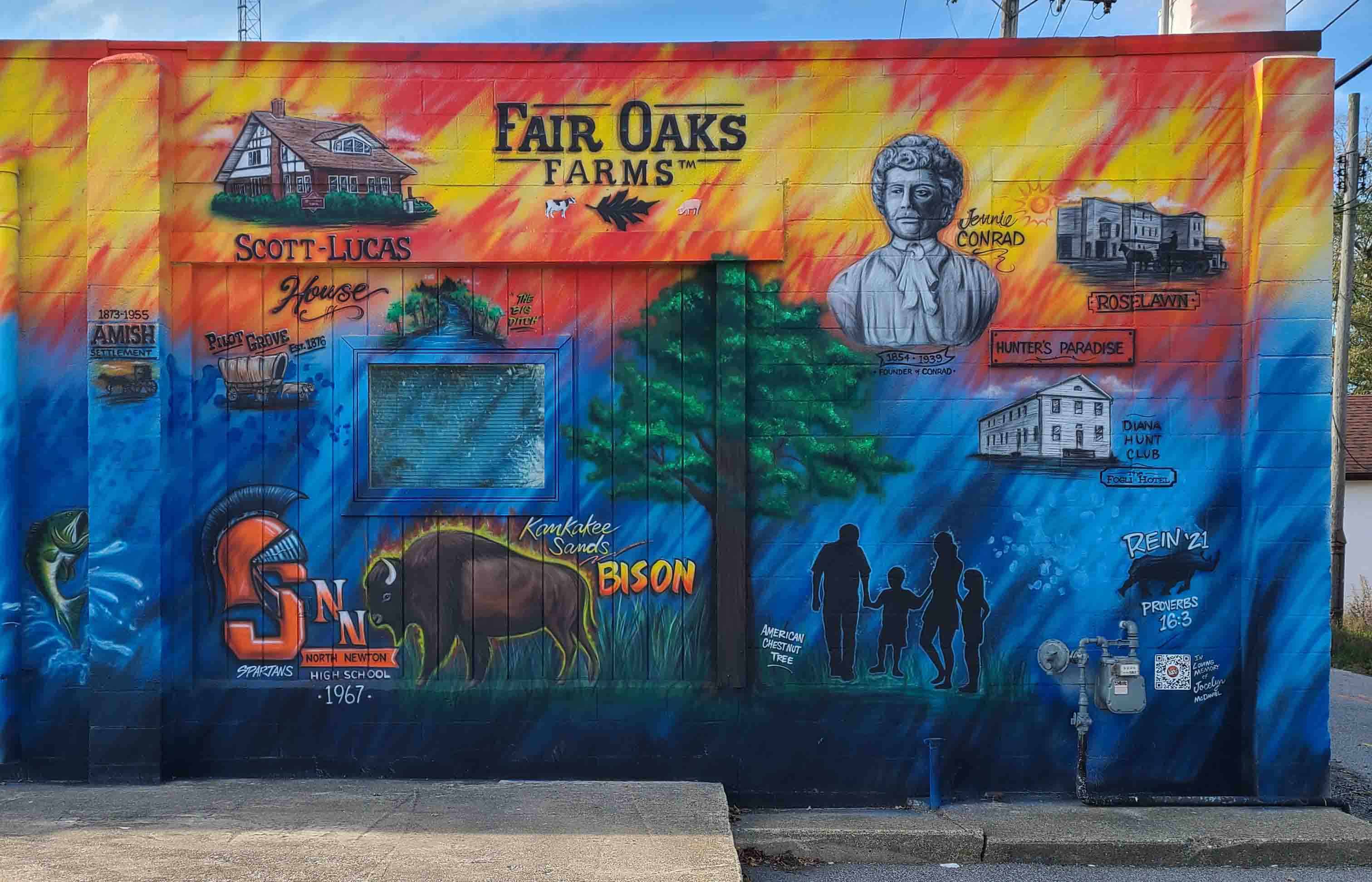
Beaver Township
Virginia Ann (Lucas) Scott was the
owner of this Prairie Art Deco style home that is located at 514 S. Main Street
in Morocco. Upon her passing away on August 15, 1998, she gifted her home and
furnishings to the Newton County Historical Society for use as a museum and to
showcase her antique collections.
The house was built by Ann’s father,
Ross Lucas. Three generations of the Lucas family resided in the home: Ross and
Laura Lucas, her grandparents; Willard and Gladys (Stockton) Lucas her parents,
and Ann and her husband Gordon Scott when they moved to Morocco in the 1980s.
In 2004, the home was listed on
the National Historic Register. It is utilized as a museum and open for social
gatherings and meetings.
Willow Slough Fish &
Game Area
Beaver/Lake Township
Originally known as the Kankakee
River State Park and Forest, Indiana’s 18th State Park would occupy three
locations: Lake Township (Kankakee River State Park) and Beaver and
McClellan Townships (Forest). The parks were created from funding from
House Bill No. 64, authored by Representative Howard Heistand of Kentland in
1947.
Kankakee River State Park
Lands were donated by Murray D.
Baker and Dr. and Mrs. Ray S. Churchill. More than 3700 witnessed the
dedication on August 3, 1952. In 1963 with additional land donations, the park
was renamed LaSalle Fish and Wildlife Area.
Forest Park
Known today as Willow Slough Fish
and Game Area, the acreage today covers 9,956 acres in Beaver and McClellan
Townships. The first lands, 3,767 acres were held by Everett Madison, who sold
them to the State of Indiana utilizing the Pittman-Robertson program. The
development of the land included a 2500-acre lake that was named for Morocco
Attorney J. C. Murphey. A dam was built over the Riner-Houseworth ditch forming
the lake.
McClellan Township
As part of a bicentennial project in
2016, 23 American bison were brought to Kankakee Sands preserve in McClellan
Township. The wild bison herd was brought from South Dakota to help maintain
the natural habitat. The herd roams free in a 1,060-acre pasture at Kankakee
Sands, where hiking is prohibited for safety reasons, but a viewing area and
interpretive area are available to see America’s National Mammal. The bison
viewing area is open from 7 a.m. CT to dusk. The Nature Conservancy, which owns
and manages thirteen bison herds in North America, manages the Indiana
herd.
Kankakee
Sands is an 8,300-acre prairie and savanna habitat open every day of the year
for public enjoyment.
North Newton School
Corporation
North Newton Jr.-Sr. High School is
a multi-community high school consisting of grades 7-12 located in rural
McClellan Township, serving the students in the towns of Lake Village, Mount
Ayr, Roselawn, Sumava Resorts, Thayer, and Morocco. The Jr.-Sr. school mascot
is the Spartan; colors are blue, white, and orange; the annual yearbook is
called “The Olympian.”
There are three elementary schools
serving grades K-6. In the north, Lake Village Elementary, Lake Village, mascot
is the Tiger and Lincoln Elementary, Roselawn, mascot is the Lincoln Eagles; in
the south, Morocco Elementary, Morocco, mascot is the Morocco Beavers.
The North Newton School Corporation
was formed in 1963 with Lawrence Bannon as Superintendent. 1968 was the first
year of classes at North Newton Jr.-Sr. High School.
Colfax Township
Recognized as the #1 agritourism
destination in the Midwest, Fair Oaks Farms is the nation’s leading agriculture
attraction located in Colfax Township. The founders of Fair Oaks Farms, Mike
and Sue McCloskey, opened their doors in 2004 with the purpose to showcase the
practices and innovation of their original four dairy farms.
Over the years they have added to
the Dairy Adventure and farm tour the Pig Adventure, Crop Adventure, Mooville
(an outdoor play area), the Orchard, a hotel, a cafe and restaurant, a
gas/convenience store, and the production of their own farm fresh products.
They continue to develop other projects such as pollinators, egg production,
vertical farming, aquaculture, and the role that science, technology, engineering,
and math play in the story of modern agriculture.
Jennie Conrad, the founder of Conrad
Lake Township
One of Newton County’s largest
landowners in her time, Jennie M. Conrad was the daughter of Lemuel and Jane
Milk, born near Kankakee, Illinois. She came to Newton County in 1890 when she
came into possession of 5,000 acres of land after her father’s death. She
engaged in active farming and was one of the most successful stock and hog
raisers in the state. She specialized in Aberdeen-Angus cattle and Spotted
Poland China hogs. Her ranch was known as Oak Dene Farms.
During her lifetime she spent
considerable time traveling and visited many foreign lands. She was an
accomplished conversationist and could speak several languages.
When the Chicago and Southern
Railroad was built in 1907, at the age of 50 she obtained a perpetual right for
a station and proceeded to build her town of Conrad. A post office, church,
schoolhouse, and a building for manufacturing cement building material were
sufficient to make a complete town. A general store, blacksmith, and hotel
would be added to the list of businesses. Homes were also built for those under
Jennie’s employment.
Jennie married George E. Conrad in
September 1878. They had one son, Platt Milk Conrad 1880-1960. Jennie died on
September 9, 1939, at the age of 85.
Hard times, numerous lawsuits and
payouts led Jennie to mortgage much of her 5,000 acres. By the time of her
death, only 1200 acres remained. These lands were left to her son and managed
by a Chicago firm until his death in 1960.
Lincoln Township
While squirrel hunting in Roselawn,
Bob Hoycus spotted something on the ground that looked like sea urchins. They
were green and had prickly things all over them, about the size of a billiard
ball. His research included an article in National Geographic written about the
American Chestnut Foundation who were trying to breed a resistant strain of
chestnut tree. The photos of the burrs in the magazine looked identical to the
burr he held in his hand.
Bob tried to grow some trees from
the nuts but did not realize he was planting infertile nuts – they fall first.
The fertile ones fall the end of September. Eventually, Bob contacted the
American Chestnut Foundation who sent a scientist to examine the tree. Turns out,
it’s the largest chestnut tree in Indiana. There were actually four of them in
the area. The scientist returned with pollen from his trees and then bagged the
pollen with the flowers in the top of the biggest tree. He returned in the fall
and harvested them. The Hardwood Tree Improvement and Regeneration Center at
Purdue now has Chestnut trees growing from the Roselawn tree.
The Newton County Historical
Society placed a historical marker at the site in 2010, located just west of
the I-65 exit on SR 10 in Lincoln Township.
Lincoln Township
Lincoln Township
Life along the Kankakee in northern
Newton County prior to and at the turn of the century was anything but slow and
meandering. Business boomed from the bountiful timber along the riverbanks;
frogs, oysters and fish were drawn from its waters and served at local
restaurants and many in the Chicago area; visitors would flock to the water to
partake in a slow boat ride up and down the river. Hunt clubs such as the Diana
Hunt Club in Thayer and The Fogli Hotel teemed with visitors from all over the
world to hunt waterfowl, fish the river or simply stay awhile and enjoy the
calm and cool atmosphere of the area.
Both facilities are located along
SR 55, north of Thayer in Lincoln Township. Historical markers were placed at
each location in 2010 by the Newton County Historical Society.
The family icon is a symbol of the
high quality of life we enjoy in Newton County. Many of the homes and farms
boast multiple generations of ownership, with anticipation that many more will
follow in their ancestor’s footsteps. Our communities were built with hard work
and determination and our business districts continue to grow and thrive to
meet the needs and challenges moving forward into the future. We are proud to
call Newton County our home!
Rein Bontreger has been a local
resident of both Newton and Jasper counties for the past 47 years. Moving to
north of Mount Ayr at age 11 from Bremen, Indiana, he graduated from North
Newton High School in 1981. He started his business, Reinforcements Design, in
1985 in Rensselaer, developing self-taught skills of airbrushing and hand
lettering on signs and vehicles. In the decades since, he has expanded into
various additional methods of signs, graphics and shirt printing.
Bontreger has enjoyed large graphic
challenges over the years, which has led to the recent interest in murals. In
2020, he created and painted a mural in Rensselaer’s Iroquois Park using local
historical subjects and interests to complete the project.
Utilizing that same methodology,
Bontreger created this large mural on the east side of the Newton County
Historical Society building highlighting various points of interest pertaining
to Newton County.
Newton County Historical Society
It is not known when the first
Newton County Historical Society came into existence, or how long they were
active, but we do know that they were holding meetings from time to time at
George Ade’s home, Hazelden. They had on display there several Newton County
artifacts, which remain there today. During their time, the McCray home in
Kentland was donated to the society, but being unable to maintain the home, the
house and contents were sold. Proceeds from this sale were utilized to
establish the McCray Scholarship, awarded to a Newton County graduate through
2014.
In 1991, a group of locals
interested in Newton County history, gathered together and decided to resurrect
the historical society. Determined to be an active group, they began planning
different programs and projects focusing on the preservation of Newton County
history. The membership has grown to include 61 lifetime members!
In 1998 Ann Lucas Scott gifted her
home to the historical society. Proceeds from her farm land maintain the house
and property, as well as fund the Scott-Lucas Scholarship, which is awarded
annually to a North Newton graduate.
The Family History Division
was formed to act as the publishing arm of the society. Inquiries regarding
Newton County families are also researched and answered by members of this
group.. The republication of local histories, compilations of township
histories and informative brochures are now available once again for purchase
due to the efforts of this group. In 2000, the Family History Division
published Volume 1 of the “Historical Coloring Book.” In 2006, Volume 2 was
published. The books are distributed each year to the fourth grade classes in Newton
County.
“The Newcomer,” the
society’s newsletter, first appeared in 1994-1996 containing local historical
facts and photographs of Newton County. The edition was resurrected in 1999,
expanding from the original 4 pages up to 32, over the years.
A project that took priority was the
walking of Newton County cemeteries and recording the inscriptions from the
stones. In 1997, Vol I – Lake, McClellan, Beaver and Washington Township data
was published. In time, all of the original recordings were posted on the
society website, making them available to everyone.
Since 1998 in conjunction with the
Indiana Gen Web Project, a web site was created that today offers a variety of
genealogical records and information for those researching their ancestry or
local history.
In 2010, in conjunction with the
Newton County Sesquicentennial, landmarks in Newton County were documented in a
brochure and designated on the 2010 Newton County map., giving residents the
ability to make a driving tour throughout the county, visiting the landmarks.
Signs were placed at each location by the society.
Public Relations/Special Events: Our members serve as representatives of the society at public events
that are held throughout the county, such as the Newton County Pun’kin Vine
Fair. This group has presented cemetery walks of Riverside Cemetery in Brook
and Fairlawn Cemetery in Kentland.
They have hosted many tours of the Resource Center to classes of
Newton County third and fourth grade students presenting facts and information
to them about the county.
Display Window: This
creative and inventive group are responsible for the spectacular window
displays at the Resource Center in Kentland. Over the past the windows have
held collections of children’s toys, celebrations of our High School Alumni
Associations, Newton County Landmarks, Christmas in Newton County, and 1816:
Life on the Kankakee.
The Resource Center is
located at the corner of 4th Street and US 24 in Kentland. It is the permanent home of the society.
The displays are a variety of
artifacts and memorabilia from all aspects of the county. Our library shelves
are filled with local history books, local family history records, yearbooks,
county records and much more.
Our newspaper archives include hard
volumes of the Newton County Enterprise and Morocco Courier.
Microfilm of these newspapers are also available. From what started as a bunch
of old newspapers being stored initially in the well-house at Hazelden, it is
suffice to say . . .
“We’ve come a long
way from the well house!”