La Porte County, Indiana
Formation and Boundary Changes
Transcribed by: Donna M. Nelson
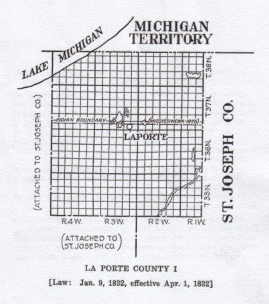
LA PORTE COUNTY I
JANUARY 9, 1832: Formation by statute, effective April 1, 1832. The formation affected St. Joseph County and attached territory.
BOUNDARIES: “Beginning at the state line, which divides the state of Indiana and Michigan territory, and at the north-west corner of township No. 38, north of range No. 4, west of the second principal meridian; thence, running east with said state line, to the centre of range No. 1, west of said meridian; thence south, twenty-two miles, thence west parallel with the said state line, twenty-one miles, thence north to the place of beginning.” Laws of Indiana, 1831-32, p. 9.
A law of February 16, 1839, defined the southern boundary of La Porte County as the line between townships 34 and 35 north. Ibid., 1838-39 (general), p. 70.
The territory south of the Mississinewa Treaty line was not ceded by the Indians until October, 1832.
COUNTY SEAT: La Porte was selected as the county seat in late September or early October, 1832, by commissioners appointed under the act forming the county. It has never been changed, though there have been attempts to remove it. Ibid., 1831-32, p. 9; Daniels, History and Biographical Record of La Porte County, 33-34, 39-42
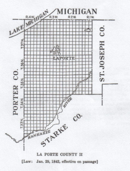
LA PORTE COUNTY II
JANUARY 29, 1842: Alteration by statute attaching a part of Starke County to the county of La Porte, effective on passage.
BOUNDARY CHANGE: The law provided that “all that part of Stark(e) county which lies north of the Kankakee river be . . . attached permanently to the county of Laporte.” Laws of Indiana, 1841-42 (general), p. 152.
In the law defining county boundaries in the Revised Statutes of 1842-43, Lake Michigan is made the boundary, where it touches the county. By a law of February 10, 1851, the northern boundary was “extended to the northern line of this state.” Revised Statutes of Indiana, 1842-43, pp. 88-89; Laws of Indiana, 1850-51 (general), p. 58.
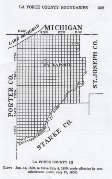
LA PORTE COUNTY III
JANUARY 14, 1850: Alteration under provisions of statute of January 14, 1850, in force from July 4, 1850, made effective by order of commissioners of La Porte County, July 10, 1850.
BOUNDARY CHANGE: The act provided that all that part of St. Joseph County described as follows: “beginning at the present county line, at the north-west corner of section twenty-two, township thirty seven north, of range one west, thence with the north east corner of said section twenty-three, thence south with the section line, until it shall strike the Great Kankakee river, thence with said river to the present county line, may be attached to the county of La Porte.” The board doing county business in and for the county of La Porte was authorized, “at their first or any subsequent meeting, after the taking effect of this act, to attach the said territory to any of the townships in the said county of Laporte.” By an order of July 10, 1850, the Board of Commissioners of La Porte county divided the territory described between Wills and Pleasant townships, La Porte County. Lincoln Township, in which part of this territory now lies, was not organized until 1866. Laws of Indiana, 1849-50 (general), pp. 114-15; History of La Porte County, 443-43, 446.
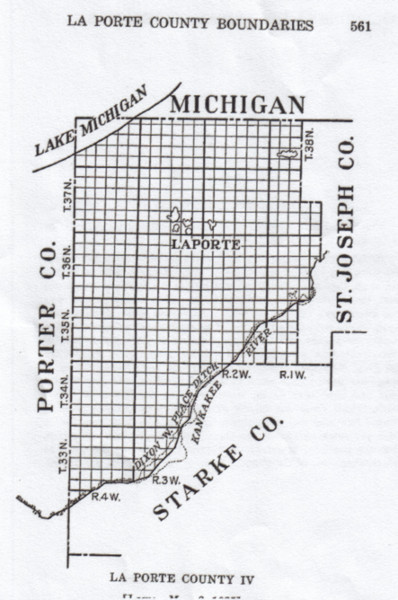
LA PORTE COUNTY IV
MARCH 2, 1925: Alteration by statute defining the boundaries of La Porte County.
BOUNDARIES: “Beginning at a point on Lake Michigan where the state line between the states of Michigan and Indiana strikes the same, thence east with the said line to the centre of range one west, thence south with said line to the north-west corner of section twenty-two (22) in township thirty-seven north, of range one west, thence with the north line of said section and that of section twenty-three (23) to the northeast corner of said section twenty-three (23), thence south with the section line until it shall strike the great Kankakee river, thence with said river to the centre of range one west, thence south to the line dividing townships thirty-four and thirty-five north, thence west to the Dixon W. Place ditch, thence down the middle of said ditch to the line dividing ranges four and five west, thence north to Lake Michigan, thence with the same eastwardly to the place of beginning: Provided, that the northern boundary shall extend to, and be the same as the northern line of the state.” Laws of Indiana, 1925, pp. 122-23.
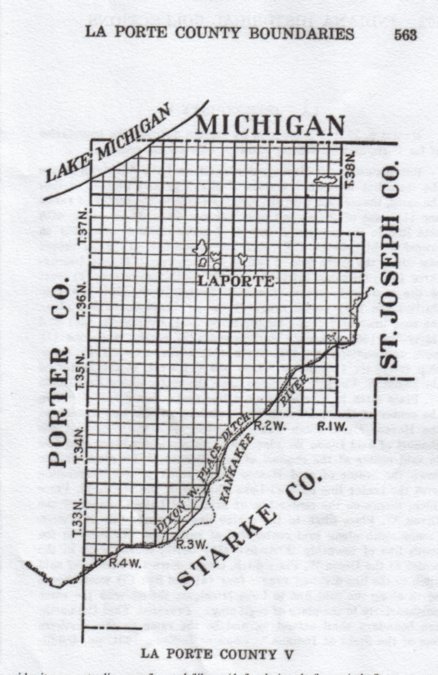
LA PORTE COUNTY V
MARCH 9, 1931: Alteration by statute defining the boundaries of La Porte and St. Joseph counties, effective on passage.
BOUNDARIES: “Beginning at a point on Lake Michigan where the state line between the state of Michigan and Indiana strikes the same, thence east with the said state line to the center of range one (1) west of the second principal meridian, thence south with said line to the northwest corner of section twenty-two (22) in township thirty-seven (37) north, of range one (1) west, thence east along the north line of sections twenty-two (22) and twenty-three (23), township thirty-seven (37) north, range one (1) west to the northeast corner of section twenty-three (23) township thirty-seven (37) north, range (1) west, thence south and along the east lines of sections twenty-three (23), twenty-six (26) and thirty-five (35), township thirty seven (37) north, range one (1) west, and sections two (2), eleven (11) and fourteen (14), township thirty-six (36) north, range one (1) west, to the center of the Dixon W. Place ditch, thence down the center of the said Dixon W. Place ditch to a point where a line protracted due north from the center of the channel of the beginning of the east branch of the Horace Miller ditch would intersect with the center of the channel of said Dixon W. Place ditch, thence south along said line to said center of the channel of said Horace Miller ditch, thence down the center of said Horace Miller ditch to the intersection with the center line of Mud Lake Channel of the Dixon W. Place ditch, thence on the center line of said Mud Lake channel of the Dixon W. Place ditch to the center line of range one (1) west, thence south along said center line of range one (1) west to the south line of township thirty-five (35) north, thence west to the center of the Dixon W. Place ditch, thence down the middle of said ditch to the line dividing ranges four (4) and five (5) west, thence north along the said line to Lake Michigan, thence with the same northeasterly to the place of beginning: Provided, That the northern boundary shall extend to, and be the same as the northern line of the State of Indiana.” Laws of Indiana, 1931, pp. 450-511.
Transcribed for La Porte County, Indiana GEN WEB by Donna Nelson, 22 February, 2006. SOURCE: Indiana Boundaries: territory, state and county Author: George Pence, Published by: Indiana Historical Bureau, 1933